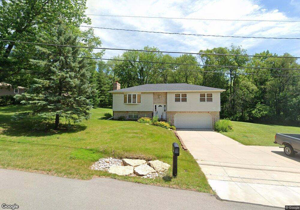
4817 Lorton Ave Davenport, IA 52807
North Side NeighborhoodEstimated Value: $259,000 - $269,000
3
Beds
2
Baths
1,332
Sq Ft
$199/Sq Ft
Est. Value
About This Home
This home is located at 4817 Lorton Ave, Davenport, IA 52807 and is currently estimated at $264,824, approximately $198 per square foot. 4817 Lorton Ave is a home located in Scott County with nearby schools including Jones Park Elementary School, Eisenhower Elementary School, and Casey County Middle School.
Ownership History
Date
Name
Owned For
Owner Type
Purchase Details
Closed on
Jun 21, 2023
Sold by
Hahn Donald M and Hahn Donald M
Bought by
Mitchell Joseph W
Current Estimated Value
Home Financials for this Owner
Home Financials are based on the most recent Mortgage that was taken out on this home.
Original Mortgage
$119,515
Outstanding Balance
$116,427
Interest Rate
6.79%
Mortgage Type
VA
Estimated Equity
$148,397
Create a Home Valuation Report for This Property
The Home Valuation Report is an in-depth analysis detailing your home's value as well as a comparison with similar homes in the area
Home Values in the Area
Average Home Value in this Area
Purchase History
| Date | Buyer | Sale Price | Title Company |
|---|---|---|---|
| Mitchell Joseph W | $117,000 | None Listed On Document |
Source: Public Records
Mortgage History
| Date | Status | Borrower | Loan Amount |
|---|---|---|---|
| Open | Mitchell Joseph W | $119,515 |
Source: Public Records
Tax History Compared to Growth
Tax History
| Year | Tax Paid | Tax Assessment Tax Assessment Total Assessment is a certain percentage of the fair market value that is determined by local assessors to be the total taxable value of land and additions on the property. | Land | Improvement |
|---|---|---|---|---|
| 2025 | $3,850 | $255,060 | $45,520 | $209,540 |
| 2024 | $3,900 | $234,110 | $45,520 | $188,590 |
| 2023 | $3,736 | $234,110 | $45,520 | $188,590 |
| 2022 | $3,726 | $183,800 | $39,020 | $144,780 |
| 2021 | $3,726 | $182,590 | $39,020 | $143,570 |
| 2020 | $3,488 | $170,530 | $39,020 | $131,510 |
| 2019 | $3,368 | $158,620 | $39,020 | $119,600 |
| 2018 | $3,214 | $158,620 | $39,020 | $119,600 |
| 2017 | $3,142 | $155,030 | $39,020 | $116,010 |
| 2016 | $3,022 | $146,660 | $0 | $0 |
| 2015 | $3,022 | $150,450 | $0 | $0 |
| 2014 | $3,148 | $150,450 | $0 | $0 |
| 2013 | $3,090 | $0 | $0 | $0 |
| 2012 | -- | $139,480 | $36,750 | $102,730 |
Source: Public Records
Map
Nearby Homes
- 4919 Lorton Ave
- 2422 E 51st St Unit E
- 2403 E 51st St Unit 102E
- 2321 E 47th St
- 2916 E 45th Ct
- 2318 E 46th St
- 2924 E 45th Ct
- 2919 E 44th Ct
- 2203 E 46th St
- 2723 E 58th St
- 4230 Jersey Ridge Rd
- 4005 Forest Rd
- 1960 E 50th Ct
- 4406 Belle Ave
- 5811 Duggleby Ave
- 4324 Spring St
- 3801 Fernwood Ct
- 4600 Eastern Ave
- 2506 E 35th Street Ct
- 5810 Indigo Ave
- 4807 Lorton Ave
- 4835 Lorton Ave
- 4822 Lorton Ave
- 4810 Lorton Ave
- 4838 Lorton Ave
- 4744 Lorton Ave
- 4907 Lorton Ave
- 4727 Lorton Ave
- 4834 Fairhaven Ct
- 4828 Fairhaven Rd
- 4728 Lorton Ave
- 4908 Lorton Ave
- 4834 Fairhaven Ct
- 4840 Fairhaven Ct
- 4840 Fairhaven Ct
- 4846 Fairhaven Ct
- 4846 Fairhaven Ct
- 4920 Lorton Ave
- 4711 Woodland Dr
- 4822 Fairhaven Ct