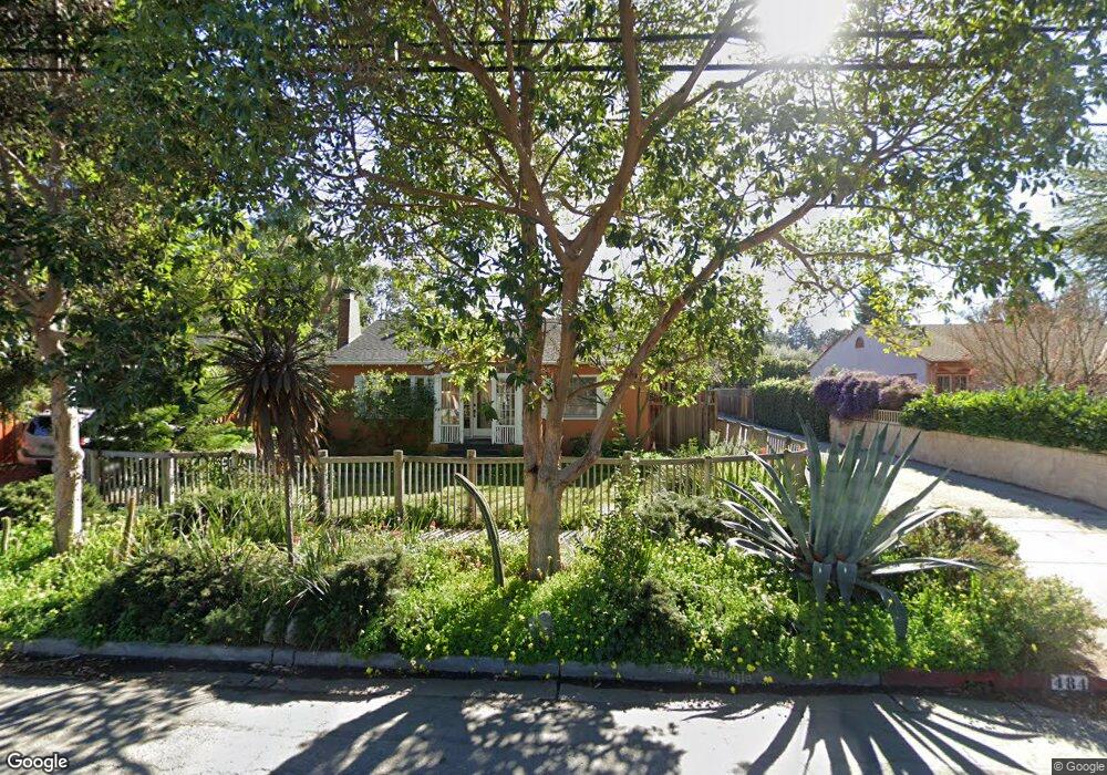
482 Oconnor St Menlo Park, CA 94025
The Willows NeighborhoodEstimated Value: $2,242,000 - $2,903,000
3
Beds
2
Baths
1,752
Sq Ft
$1,452/Sq Ft
Est. Value
About This Home
This home is located at 482 Oconnor St, Menlo Park, CA 94025 and is currently estimated at $2,543,763, approximately $1,451 per square foot. 482 Oconnor St is a home located in San Mateo County with nearby schools including Laurel Elementary School, Hillview Middle School, and Menlo-Atherton High School.
Ownership History
Date
Name
Owned For
Owner Type
Purchase Details
Closed on
Oct 29, 2012
Sold by
Livingston Philip Kent and Livingston Patricia Kemp
Bought by
Livingston Philip Kent and Livingston Patricia Kemp
Current Estimated Value
Home Financials for this Owner
Home Financials are based on the most recent Mortgage that was taken out on this home.
Original Mortgage
$405,000
Outstanding Balance
$280,392
Interest Rate
3.43%
Mortgage Type
New Conventional
Estimated Equity
$2,263,371
Purchase Details
Closed on
Aug 14, 2000
Sold by
Kent Livingston Philip
Bought by
Livingston Philip Kent and Livingston Patricia Kemp
Purchase Details
Closed on
Nov 29, 1995
Sold by
Singh Satwant
Bought by
Livingston Philip Kent
Home Financials for this Owner
Home Financials are based on the most recent Mortgage that was taken out on this home.
Original Mortgage
$160,000
Interest Rate
7.48%
Create a Home Valuation Report for This Property
The Home Valuation Report is an in-depth analysis detailing your home's value as well as a comparison with similar homes in the area
Home Values in the Area
Average Home Value in this Area
Purchase History
| Date | Buyer | Sale Price | Title Company |
|---|---|---|---|
| Livingston Philip Kent | -- | Chicago Title Company | |
| Livingston Philip Kent | -- | -- | |
| Livingston Philip Kent | $200,000 | First American Title Co |
Source: Public Records
Mortgage History
| Date | Status | Borrower | Loan Amount |
|---|---|---|---|
| Open | Livingston Philip Kent | $405,000 | |
| Closed | Livingston Philip Kent | $160,000 |
Source: Public Records
Tax History
| Year | Tax Paid | Tax Assessment Tax Assessment Total Assessment is a certain percentage of the fair market value that is determined by local assessors to be the total taxable value of land and additions on the property. | Land | Improvement |
|---|---|---|---|---|
| 2025 | $7,519 | $487,379 | $166,113 | $321,266 |
| 2023 | $7,519 | $468,455 | $159,663 | $308,792 |
| 2022 | $7,113 | $459,271 | $156,533 | $302,738 |
| 2021 | $6,809 | $450,267 | $153,464 | $296,803 |
| 2020 | $6,745 | $445,652 | $151,891 | $293,761 |
| 2019 | $6,666 | $436,915 | $148,913 | $288,002 |
| 2018 | $6,472 | $428,350 | $145,994 | $282,356 |
| 2017 | $6,365 | $419,953 | $143,132 | $276,821 |
| 2016 | $6,080 | $411,720 | $140,326 | $271,394 |
| 2015 | $6,023 | $405,538 | $138,219 | $267,319 |
| 2014 | $5,913 | $397,596 | $135,512 | $262,084 |
Source: Public Records
Map
Nearby Homes
- 1983 Euclid Ave
- 480 E Okeefe St Unit 206
- 315 E Okeefe St
- 90 Crescent Dr
- 2055 Oakwood Dr
- 2138 Dumbarton Ave
- 2118 Addison Ave
- 2212 Dumbarton Ave
- 2148 Ralmar Ave
- 108 Durham St
- 519 Central Ave
- 1049 Woodland Ave
- 1908 Cooley Ave
- 505 Runnymede St Unit C
- 00 Clarke Ave
- 985 Lincoln Ave
- 413 Gilbert Ave
- 2247 Menalto Ave
- 2340 Cooley Ave
- 2216 Clarke Ave
- 1987 Euclid Ave
- 1989 Euclid Ave
- 474 Oconnor St
- 1985 Euclid Ave
- 1981 Euclid Ave
- 484 Oconnor St
- 471 Oconnor St
- 483 Oconnor St
- 471 O' Connor St
- 1971 Euclid Ave
- 476 Oconnor St
- 448 Oconnor St
- 1990 Byers Dr
- 465 Oconnor St
- 1984 Byers Dr
- 1965 Euclid Ave
- 459 Oconnor St
- 1971 Euclid Ave
- 1978 Byers Dr
- 451 Oconnor St
Your Personal Tour Guide
Ask me questions while you tour the home.