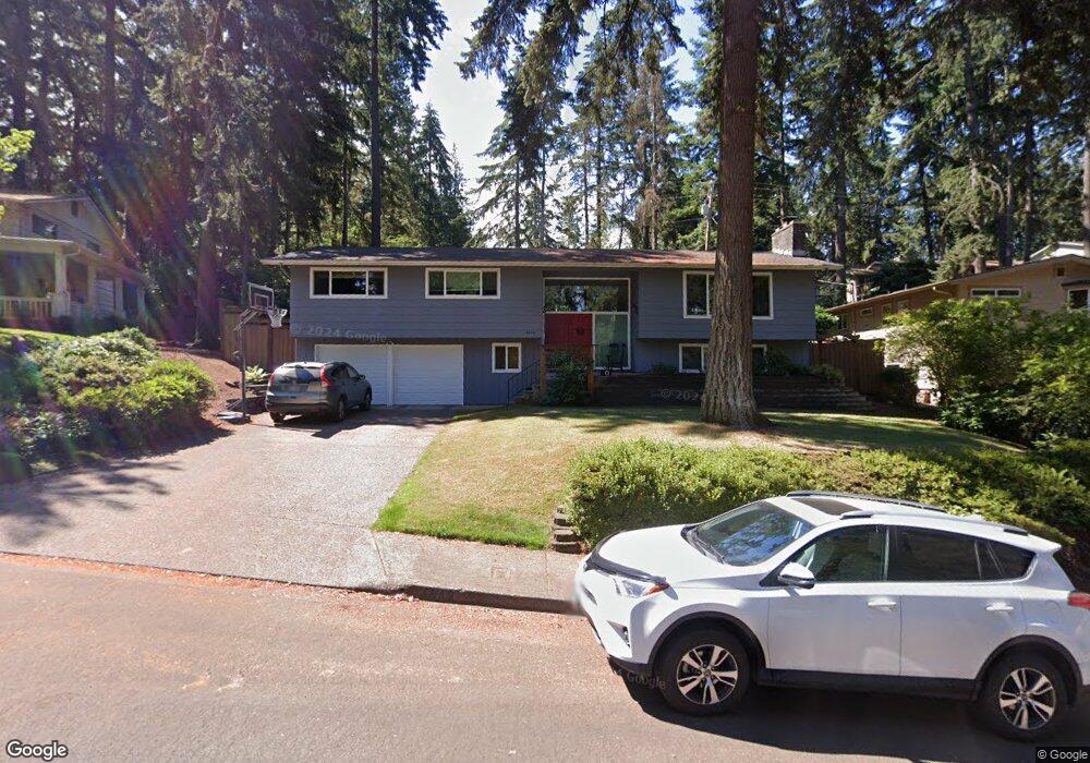
4840 Brookwood St Eugene, OR 97405
Southeast Eugene NeighborhoodEstimated Value: $584,000 - $625,000
4
Beds
3
Baths
2,430
Sq Ft
$249/Sq Ft
Est. Value
About This Home
This home is located at 4840 Brookwood St, Eugene, OR 97405 and is currently estimated at $604,567, approximately $248 per square foot. 4840 Brookwood St is a home located in Lane County with nearby schools including Edgewood Community Elementary School, Spencer Butte Middle School, and South Eugene High School.
Ownership History
Date
Name
Owned For
Owner Type
Purchase Details
Closed on
Jun 26, 2009
Sold by
Thorne Lewis C and Thorne Kathleen C
Bought by
Ohrtman Ty and Ohrtman Sara
Current Estimated Value
Home Financials for this Owner
Home Financials are based on the most recent Mortgage that was taken out on this home.
Original Mortgage
$293,584
Outstanding Balance
$184,893
Interest Rate
4.79%
Mortgage Type
FHA
Estimated Equity
$419,674
Create a Home Valuation Report for This Property
The Home Valuation Report is an in-depth analysis detailing your home's value as well as a comparison with similar homes in the area
Home Values in the Area
Average Home Value in this Area
Purchase History
| Date | Buyer | Sale Price | Title Company |
|---|---|---|---|
| Ohrtman Ty | $299,000 | First American Title |
Source: Public Records
Mortgage History
| Date | Status | Borrower | Loan Amount |
|---|---|---|---|
| Open | Ohrtman Ty | $293,584 |
Source: Public Records
Tax History
| Year | Tax Paid | Tax Assessment Tax Assessment Total Assessment is a certain percentage of the fair market value that is determined by local assessors to be the total taxable value of land and additions on the property. | Land | Improvement |
|---|---|---|---|---|
| 2025 | $6,251 | $320,848 | -- | -- |
| 2024 | $6,174 | $311,503 | -- | -- |
| 2023 | $6,174 | $302,431 | $0 | $0 |
| 2022 | $5,784 | $293,623 | $0 | $0 |
| 2021 | $5,432 | $285,071 | $0 | $0 |
| 2020 | $5,451 | $276,768 | $0 | $0 |
| 2019 | $5,265 | $268,707 | $0 | $0 |
| 2018 | $4,956 | $253,283 | $0 | $0 |
| 2017 | $4,734 | $253,283 | $0 | $0 |
| 2016 | $4,605 | $245,906 | $0 | $0 |
| 2015 | $4,468 | $238,744 | $0 | $0 |
| 2014 | $4,393 | $231,790 | $0 | $0 |
Source: Public Records
Map
Nearby Homes
- 4845 Brookwood St
- 4734 Brookwood St
- 395 E 46th Ave
- 4425 Hilyard St
- 4680 W Hillside Dr
- 4427 Fox Hollow Rd Unit 7
- 36 Westbrook Way
- 17 Westbrook Way
- 21 Westbrook Way
- 4429 Fox Hollow Rd Unit 3
- 892 Sprague St
- 4364 Fox Hollow Rd
- 4733 E Amazon Dr
- 4320 Fox Hollow Rd
- 296 Woodridge Dr
- 278 Rockridge Ct
- 143 Treehill Loop Unit 143
- 936 E 43rd Ave
- 152 Treehill Loop Unit 152
- 170 E 40th Ave
- 4830 Brookwood St
- 4846 Brookwood St
- 555 E 50th Ave
- 535 E 50th Ave
- 575 E 50th Ave
- 4820 Brookwood St
- 4825 Brookwood St
- 515 E 50th Ave
- 4835 Brookwood St
- 4848 Brookwood St
- 595 E 50th Ave
- 4805 Brookwood St
- 495 E 50th Ave
- 4810 Brookwood St
- 562 Kingswood Ave
- 600 Kingswood Ave
- 605 E 50th Ave
- 510 E 50th Ave
- 550 E 50th Ave
- 530 E 50th Ave
Your Personal Tour Guide
Ask me questions while you tour the home.