
487 Boylston St Unit 3 Brookline, MA 02445
Brookline Village NeighborhoodEstimated payment $8,929/month
Highlights
- Medical Services
- No Units Above
- Property is near public transit
- John D. Runkle School Rated A
- Deck
- Family Room with Fireplace
About This Home
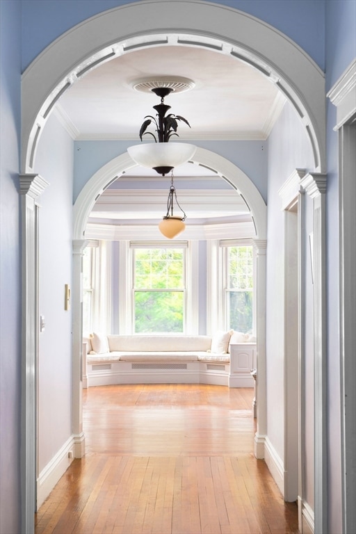
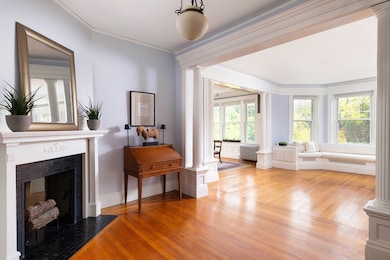
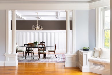
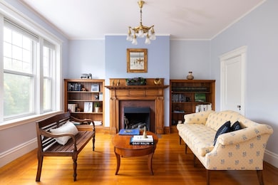
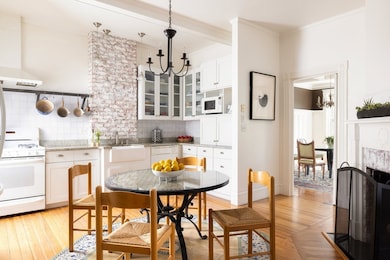
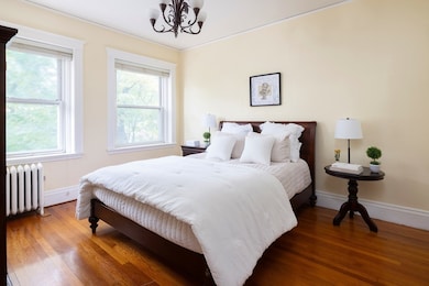
Elegant “Manhattan-style” floor-through Penthouse condominium offering 4 bedrooms, 2 full baths, and 2,276 sq ft of sun-filled living space. A gracious foyer with decorative fireplace opens to a bright living room with built-in seating and flows into a spacious family room featuring a fireplace and custom bookcases. The banquet-sized dining room showcases wainscoting and a built-in china cabinet, perfect for entertaining. A large eat-in kitchen with decorative fireplace provides wonderful everyday living space, The hallway leading to the bedrooms is graced by classic archways that enhance the home’s sense of character and flow. Enjoy the year-round sunroom and common rook deck with views of downtown Boston! Defining features of this home include refined millwork, crown moldings, high ceilings, and hardwood floors exemplifying timeless architectural detail. Additional highlights include in-unit laundry, storage, and parking for 1 car. Close to T, Reservoir, Longwood Med. and Boston..
Property Details
Home Type
- Condominium
Est. Annual Taxes
- $10,251
Year Built
- Built in 1915
Lot Details
- No Units Above
HOA Fees
- $500 Monthly HOA Fees
Home Design
- Rowhouse Architecture
- Entry on the 3rd floor
- Brick Exterior Construction
- Frame Construction
- Rubber Roof
Interior Spaces
- 2,276 Sq Ft Home
- 1-Story Property
- Crown Molding
- Beamed Ceilings
- Bay Window
- Entrance Foyer
- Family Room with Fireplace
- 2 Fireplaces
- Sun or Florida Room
- Wood Flooring
- Intercom
- Basement
Kitchen
- Range
- Dishwasher
Bedrooms and Bathrooms
- 4 Bedrooms
- Primary bedroom located on third floor
- 2 Full Bathrooms
Laundry
- Laundry in unit
- Dryer
- Washer
Parking
- 1 Car Parking Space
- Off-Street Parking
- Assigned Parking
Outdoor Features
- Deck
- Enclosed Patio or Porch
Location
- Property is near public transit
- Property is near schools
Schools
- Runkle/Lincoln Elementary School
- Brookline High School
Utilities
- Window Unit Cooling System
- 3 Cooling Zones
- Central Heating
- 1 Heating Zone
- Heating System Uses Natural Gas
- Heating System Uses Steam
- 110 Volts
Listing and Financial Details
- Assessor Parcel Number 38844
Community Details
Overview
- Association fees include heat, water, sewer, insurance
- 3 Units
Amenities
- Medical Services
- Common Area
- Shops
Recreation
- Park
Pet Policy
- Call for details about the types of pets allowed
Map
Home Values in the Area
Average Home Value in this Area
Tax History
| Year | Tax Paid | Tax Assessment Tax Assessment Total Assessment is a certain percentage of the fair market value that is determined by local assessors to be the total taxable value of land and additions on the property. | Land | Improvement |
|---|---|---|---|---|
| 2025 | $13,671 | $1,385,100 | $0 | $1,385,100 |
| 2024 | $13,267 | $1,357,900 | $0 | $1,357,900 |
| 2023 | $12,731 | $1,276,900 | $0 | $1,276,900 |
| 2022 | $12,757 | $1,251,900 | $0 | $1,251,900 |
| 2021 | $12,147 | $1,239,500 | $0 | $1,239,500 |
| 2020 | $11,598 | $1,227,300 | $0 | $1,227,300 |
| 2019 | $10,784 | $1,150,900 | $0 | $1,150,900 |
| 2018 | $10,397 | $1,099,000 | $0 | $1,099,000 |
| 2017 | $10,053 | $1,017,500 | $0 | $1,017,500 |
| 2016 | $9,639 | $925,000 | $0 | $925,000 |
| 2015 | $8,981 | $840,900 | $0 | $840,900 |
| 2014 | $8,538 | $749,600 | $0 | $749,600 |
Property History
| Date | Event | Price | List to Sale | Price per Sq Ft |
|---|---|---|---|---|
| 10/23/2025 10/23/25 | For Sale | $1,440,000 | -- | $633 / Sq Ft |
Purchase History
| Date | Type | Sale Price | Title Company |
|---|---|---|---|
| Quit Claim Deed | -- | -- | |
| Deed | $515,000 | -- |
Mortgage History
| Date | Status | Loan Amount | Loan Type |
|---|---|---|---|
| Previous Owner | $417,000 | No Value Available | |
| Previous Owner | $275,000 | Purchase Money Mortgage | |
| Closed | $214,250 | No Value Available |
Source: MLS Property Information Network (MLS PIN)
MLS Number: 73447404
APN: BROO-000253-000006-000002
Disclaimer: Certain information contained herein is derived from information provided by parties other than Homes.com. All information provided is deemed reliable, but is not guaranteed to be accurate and should be independently verified.
![]() The property listing data and information, or the Images, set forth herein were provided to MLS Property Information Network, Inc. from third party sources, including sellers, lessors and public records, and were compiled by MLS Property Information Network, Inc. The property listing data and information, and the Images, are for the personal, non-commercial use of consumers having a good faith interest in purchasing or leasing listed properties of the type displayed to them and may not be used for any purpose other than to identify prospective properties which such consumers may have a good faith interest in purchasing or leasing. MLS Property Information Network, Inc. and its subscribers disclaim any and all representations and warranties as to the accuracy of the property listing data and information, or as to the accuracy of any of the Images, set forth herein.
The property listing data and information, or the Images, set forth herein were provided to MLS Property Information Network, Inc. from third party sources, including sellers, lessors and public records, and were compiled by MLS Property Information Network, Inc. The property listing data and information, and the Images, are for the personal, non-commercial use of consumers having a good faith interest in purchasing or leasing listed properties of the type displayed to them and may not be used for any purpose other than to identify prospective properties which such consumers may have a good faith interest in purchasing or leasing. MLS Property Information Network, Inc. and its subscribers disclaim any and all representations and warranties as to the accuracy of the property listing data and information, or as to the accuracy of any of the Images, set forth herein.
- 371 Walnut St
- 105 Sumner Rd
- 469 Walnut St
- 80 Dudley St
- 213 Gardner Rd
- 55 Leicester St
- 87 Greenough St Unit 1
- 87 Greenough St Unit 2
- 140 Dudley St
- 18 Chestnut Place
- 71 Greenough St Unit 71-1
- 120 Seaver St Unit A103
- 120 Seaver St Unit C-102
- 255 Tappan St
- 236 Walnut St
- 72 Cypress St Unit 1
- 20 Rice St Unit 2
- 184 Rawson Rd
- 90 Addington Rd Unit 2
- 15 Colbourne Crescent Unit 2
- 497 Boylston St Unit 1
- 101 Sumner Rd
- 101 Sumner Rd Unit 1
- 537 Boylston St Unit 3
- 180 Clark Rd Unit A
- 153 Cypress St Unit 1
- 110 Cypress St
- 158 Cypress St
- 144-146 Cypress St Unit 3
- 9 Mulford St
- 11 E Milton Rd
- 11 E Milton Rd Unit 1
- 15 E Milton Rd
- 16 Prince St Unit 1
- 323 Boylston St Unit 3##
- 110 Cypress St Unit 108
- 110 Cypress St Unit 307
- 110 Cypress St Unit 207
- 22 Chestnut Place Unit 114
- 22 Chestnut Place Unit G1
