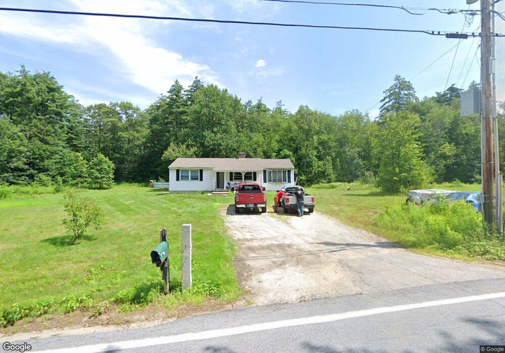
487 Pingree Hill Rd Auburn, NH 03032
Estimated Value: $401,000 - $494,000
2
Beds
1
Bath
1,261
Sq Ft
$355/Sq Ft
Est. Value
About This Home
This home is located at 487 Pingree Hill Rd, Auburn, NH 03032 and is currently estimated at $447,896, approximately $355 per square foot. 487 Pingree Hill Rd is a home located in Rockingham County with nearby schools including Auburn Village School and Pinkerton Academy.
Ownership History
Date
Name
Owned For
Owner Type
Purchase Details
Closed on
May 21, 2003
Sold by
Cote Kendall and Cote Diane S
Bought by
Walls Ramona L
Current Estimated Value
Home Financials for this Owner
Home Financials are based on the most recent Mortgage that was taken out on this home.
Original Mortgage
$194,750
Outstanding Balance
$85,074
Interest Rate
5.86%
Estimated Equity
$362,822
Purchase Details
Closed on
Oct 9, 2001
Sold by
Henderson Shawn T
Bought by
Cote Theresa N
Home Financials for this Owner
Home Financials are based on the most recent Mortgage that was taken out on this home.
Original Mortgage
$43,000
Interest Rate
6.89%
Create a Home Valuation Report for This Property
The Home Valuation Report is an in-depth analysis detailing your home's value as well as a comparison with similar homes in the area
Home Values in the Area
Average Home Value in this Area
Purchase History
| Date | Buyer | Sale Price | Title Company |
|---|---|---|---|
| Walls Ramona L | $205,000 | -- | |
| Cote Theresa N | $160,000 | -- |
Source: Public Records
Mortgage History
| Date | Status | Borrower | Loan Amount |
|---|---|---|---|
| Open | Cote Theresa N | $40,000 | |
| Open | Cote Theresa N | $194,750 | |
| Previous Owner | Cote Theresa N | $43,000 |
Source: Public Records
Tax History Compared to Growth
Tax History
| Year | Tax Paid | Tax Assessment Tax Assessment Total Assessment is a certain percentage of the fair market value that is determined by local assessors to be the total taxable value of land and additions on the property. | Land | Improvement |
|---|---|---|---|---|
| 2024 | $4,973 | $369,200 | $198,600 | $170,600 |
| 2023 | $4,656 | $369,200 | $198,600 | $170,600 |
| 2022 | $4,293 | $240,500 | $140,600 | $99,900 |
| 2021 | $4,363 | $240,500 | $140,600 | $99,900 |
| 2020 | $710 | $240,500 | $140,600 | $99,900 |
| 2019 | $4,524 | $240,500 | $140,600 | $99,900 |
| 2018 | $4,103 | $240,500 | $140,600 | $99,900 |
| 2017 | $4,448 | $210,300 | $139,700 | $70,600 |
| 2016 | $306 | $210,600 | $139,700 | $70,900 |
| 2015 | $4,362 | $210,600 | $139,700 | $70,900 |
| 2014 | $4,488 | $210,600 | $139,700 | $70,900 |
| 2013 | $4,126 | $210,600 | $139,700 | $70,900 |
Source: Public Records
Map
Nearby Homes
- 59 Hawthorne Dr
- 8 Ledgewood Dr
- 4 Ledgewood Dr
- 34 Conifer Place
- 4 Viza Ave
- 40 Pinyon Place
- 70 English Range Rd
- 54 Daniel Rd
- 50 Daniel Rd
- 52 Daniel Rd
- 55 Norwich Place
- 8 Mark Ave
- 80.5 English Range Rd
- 6 Hilda Ave
- 9 Dattillo Rd
- 7 Gena Ave
- 78 Stonebridge Dr
- 27 Cove Dr
- 45 Peach Tree Rd
- 30 Gypsum Ln Unit 29
- 471 Pingree Hill Rd
- 478 Pingree Hill Rd
- 488 Pingree Hill Rd
- 494 Pingree Hill Rd
- 463 Pingree Hill Rd
- 514 Pingree Hill Rd
- 522 Pingree Hill Rd
- 441 Pingree Hill Rd
- 453 Pingree Hill Rd
- 434 Pingree Hill Rd
- 429 Pingree Hill Rd
- 537 Pingree Hill Rd
- 425 Pingree Hill Rd
- 550 Pingree Hill Rd
- 20 Silver Hill Rd
- 409 Pingree Hill Rd
- 551 Pingree Hill Rd
- 560 Pingree Hill Rd
- 404 Pingree Hill Rd
- 0 Pingree Hill Rd