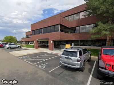
4875 Pearl East Cir Boulder, CO 80301
--
Bed
--
Bath
1,425
Sq Ft
2.47
Acres
About This Home
This home is located at 4875 Pearl East Cir, Boulder, CO 80301. 4875 Pearl East Cir is a home located in Boulder County with nearby schools including Douglass Elementary School, Nevin Platt Middle School, and Boulder High School.
Ownership History
Date
Name
Owned For
Owner Type
Purchase Details
Closed on
Jan 8, 2019
Sold by
Upi P7 East Llc
Bought by
Western Office Protfolio Property Owner
Purchase Details
Closed on
Mar 25, 1992
Bought by
Upi/P7 Pearl East Llc
Purchase Details
Closed on
Jun 21, 1990
Bought by
Upi/P7 Pearl East Llc
Purchase Details
Closed on
Sep 16, 1987
Bought by
Upi/P7 Pearl East Llc
Purchase Details
Closed on
Mar 21, 1980
Bought by
Upi/P7 Pearl East Llc
Create a Home Valuation Report for This Property
The Home Valuation Report is an in-depth analysis detailing your home's value as well as a comparison with similar homes in the area
Home Values in the Area
Average Home Value in this Area
Purchase History
| Date | Buyer | Sale Price | Title Company |
|---|---|---|---|
| Western Office Protfolio Property Owner | $150,000,000 | First American Title Ins Ncs | |
| Upi/P7 Pearl East Llc | -- | -- | |
| Upi/P7 Pearl East Llc | -- | -- | |
| Upi/P7 Pearl East Llc | -- | -- | |
| Upi/P7 Pearl East Llc | $1,612,900 | -- |
Source: Public Records
Tax History Compared to Growth
Tax History
| Year | Tax Paid | Tax Assessment Tax Assessment Total Assessment is a certain percentage of the fair market value that is determined by local assessors to be the total taxable value of land and additions on the property. | Land | Improvement |
|---|---|---|---|---|
| 2024 | $212,147 | $2,456,567 | $1,105,007 | $1,351,560 |
| 2023 | $212,147 | $2,456,567 | $1,105,007 | $1,359,930 |
| 2022 | $176,010 | $1,895,353 | $638,580 | $1,256,773 |
| 2021 | $163,143 | $1,895,353 | $638,580 | $1,256,773 |
| 2020 | $165,115 | $1,896,890 | $638,580 | $1,258,310 |
| 2019 | $162,588 | $1,896,890 | $638,580 | $1,258,310 |
| 2018 | $140,399 | $1,619,360 | $598,850 | $1,020,510 |
| 2017 | $123,764 | $1,665,470 | $598,850 | $1,066,620 |
| 2016 | $94,644 | $1,189,638 | $174,174 | $1,015,464 |
| 2015 | $89,622 | $1,153,417 | $449,123 | $704,294 |
| 2014 | $89,134 | $1,153,417 | $449,123 | $704,294 |
Source: Public Records
Map
Nearby Homes
- 1595 Macarthur Dr
- 3076 Fulton Cir
- 4861 Curie Ct
- 3701 Arapahoe Ave Unit 318
- 3601 Arapahoe Ave Unit 422
- 3601 Arapahoe Ave Unit 226
- 3105 Galileo Ln
- 3301 Arapahoe Ave Unit 106
- 3301 Arapahoe Ave Unit 219
- 3301 Arapahoe Ave Unit 204
- 3401 Arapahoe Ave Unit F402
- 3401 Arapahoe Ave Unit 315
- 4855 Edison Ave Unit 112
- 146 Butte St Unit 146
- 2445 Junction Place Unit 304
- 2445 Junction Place Unit 206
- 3116 47th St
- 4866 Franklin Dr
- 3215 Foundry Place Unit 106N
- 3215 Foundry Place Unit 101N
- 4875 Pearl East Cir
- 4875 Pearl East Cir
- 4999 Pearl East Cir Unit 201
- 4735 Walnut St Unit B
- 4735 Walnut St Unit F & G
- 4735 Walnut St Unit F
- 4735 Walnut St Unit C
- 4735 Walnut St Unit 110
- 4735 Walnut St Unit 1
- 4735 Walnut St Unit D&E
- 2555 49th St
- 4900 Pearl St Unit 500
- 4790 Pearl St
- 4790 Pearl St Unit 3
- 4790 Pearl St Unit 2
- 4770 Pearl St Unit F
- 4990 Pearl St
- 5125 Pearl Pkwy
- 1740 38th St
- 1800 38th St