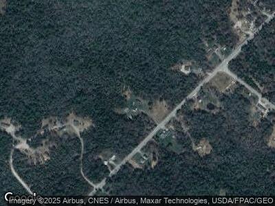
489 Eastside Rd Hancock, ME 04640
Estimated Value: $242,000 - $419,000
2
Beds
2
Baths
1,580
Sq Ft
$199/Sq Ft
Est. Value
About This Home
This home is located at 489 Eastside Rd, Hancock, ME 04640 and is currently estimated at $314,273, approximately $198 per square foot. 489 Eastside Rd is a home located in Hancock County with nearby schools including Sumner Memorial High School.
Ownership History
Date
Name
Owned For
Owner Type
Purchase Details
Closed on
Jan 30, 2020
Sold by
Bricker Dorothy M Est
Bought by
Bricker Scott A
Current Estimated Value
Purchase Details
Closed on
Feb 19, 2010
Sold by
Capurso Paul M
Bought by
Bricker Dorothy M
Home Financials for this Owner
Home Financials are based on the most recent Mortgage that was taken out on this home.
Original Mortgage
$156,800
Interest Rate
5.17%
Mortgage Type
Unknown
Create a Home Valuation Report for This Property
The Home Valuation Report is an in-depth analysis detailing your home's value as well as a comparison with similar homes in the area
Home Values in the Area
Average Home Value in this Area
Purchase History
| Date | Buyer | Sale Price | Title Company |
|---|---|---|---|
| Bricker Scott A | -- | None Available | |
| Bricker Scott A | -- | None Available | |
| Bricker Dorothy M | -- | -- |
Source: Public Records
Mortgage History
| Date | Status | Borrower | Loan Amount |
|---|---|---|---|
| Previous Owner | Bricker Dorothy M | $156,800 |
Source: Public Records
Tax History Compared to Growth
Tax History
| Year | Tax Paid | Tax Assessment Tax Assessment Total Assessment is a certain percentage of the fair market value that is determined by local assessors to be the total taxable value of land and additions on the property. | Land | Improvement |
|---|---|---|---|---|
| 2023 | $2,030 | $193,300 | $46,500 | $146,800 |
| 2022 | $2,030 | $193,300 | $46,500 | $146,800 |
| 2021 | $2,126 | $193,300 | $46,500 | $146,800 |
| 2019 | $1,861 | $173,900 | $46,500 | $127,400 |
| 2018 | $1,913 | $173,900 | $46,500 | $127,400 |
| 2017 | $1,913 | $173,900 | $46,500 | $127,400 |
| 2016 | $1,928 | $175,300 | $46,500 | $128,800 |
| 2015 | $1,814 | $175,300 | $46,500 | $128,800 |
| 2014 | $1,753 | $175,300 | $46,500 | $128,800 |
| 2013 | $1,807 | $181,600 | $46,500 | $135,100 |
Source: Public Records
Map
Nearby Homes
- 490 Eastside Rd
- 490 E Side Rd
- Lot 066 E Side Rd
- 560 Point Rd
- 133 Eastside Rd
- 1920 Us Highway 1
- 1723 U S 1
- 0 Solarina Ave Unit 1615308
- 2094 U S 1
- 8 Mariners Reach
- 2126 Us Hwy 1
- 1 Racoon Cove Rd
- 00 River Rd
- 353 E Side Rd
- 98 Meadow Point Rd
- 45 Higg St
- 330 Taunton Dr
- Lot 12 Kennel Brook Dr
- Lot 11 Kennel Brook Dr
- Lot 9 Kennel Brook Dr
- 489 Eastside Rd
- 502 Eastside Rd
- 507 Eastside Rd
- 472 Eastside Rd
- 463 Eastside Rd
- 455 Eastside Rd
- 516 Eastside Rd
- 000 Eastside Rd
- 000 E East Side Rd
- 17 Grant St
- 54 Ferry Rd
- 433 Eastside Rd
- 0 Ferry Rd Unit 863837
- 0 Ferry Rd Unit 821938
- 0 Ferry Rd Unit 1117013
- 31 Grant St
- 0 Jellison Cove Rd Unit 571447
- 0 Jellison Cove Rd Unit 386669
- 0 Jellison Cove Rd Unit 280148
- 0 Jellison Cove Rd Unit 890746
