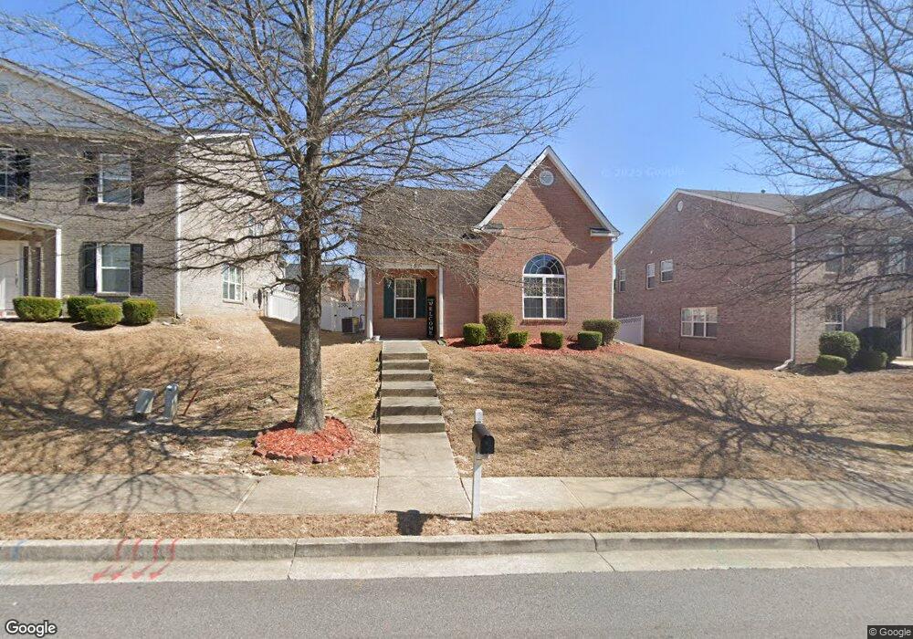
489 Townsend Bend Stockbridge, GA 30281
Estimated Value: $219,000 - $262,000
3
Beds
3
Baths
1,664
Sq Ft
$149/Sq Ft
Est. Value
About This Home
This home is located at 489 Townsend Bend, Stockbridge, GA 30281 and is currently estimated at $248,578, approximately $149 per square foot. 489 Townsend Bend is a home located in Henry County with nearby schools including Stockbridge Elementary School, Smith-Barnes Elementary School, and Stockbridge Middle School.
Ownership History
Date
Name
Owned For
Owner Type
Purchase Details
Closed on
Mar 31, 2025
Sold by
Pounds Hope K
Bought by
Hope Pounds Revocable Trust and Pounds Hope K Trust
Current Estimated Value
Purchase Details
Closed on
Sep 24, 2009
Sold by
Edson & Northbridge Llc
Bought by
Pounds Hope K
Home Financials for this Owner
Home Financials are based on the most recent Mortgage that was taken out on this home.
Original Mortgage
$109,000
Interest Rate
5.11%
Mortgage Type
New Conventional
Create a Home Valuation Report for This Property
The Home Valuation Report is an in-depth analysis detailing your home's value as well as a comparison with similar homes in the area
Home Values in the Area
Average Home Value in this Area
Purchase History
| Date | Buyer | Sale Price | Title Company |
|---|---|---|---|
| Hope Pounds Revocable Trust | -- | -- | |
| Pounds Hope K | $109,000 | -- |
Source: Public Records
Mortgage History
| Date | Status | Borrower | Loan Amount |
|---|---|---|---|
| Previous Owner | Pounds Hope K | $109,000 |
Source: Public Records
Tax History
| Year | Tax Paid | Tax Assessment Tax Assessment Total Assessment is a certain percentage of the fair market value that is determined by local assessors to be the total taxable value of land and additions on the property. | Land | Improvement |
|---|---|---|---|---|
| 2025 | $4,685 | $112,960 | $16,000 | $96,960 |
| 2024 | $4,685 | $111,200 | $16,000 | $95,200 |
| 2023 | $5,020 | $118,880 | $18,000 | $100,880 |
| 2022 | $3,759 | $92,360 | $12,800 | $79,560 |
| 2021 | $2,804 | $67,280 | $12,800 | $54,480 |
| 2020 | $2,675 | $63,880 | $12,800 | $51,080 |
| 2019 | $2,396 | $58,200 | $10,000 | $48,200 |
| 2018 | $2,247 | $54,320 | $10,000 | $44,320 |
| 2016 | $1,566 | $43,640 | $8,000 | $35,640 |
| 2015 | $1,408 | $38,760 | $7,640 | $31,120 |
| 2014 | $1,217 | $33,680 | $4,800 | $28,880 |
Source: Public Records
Map
Nearby Homes
- 431 Broder Farms Dr
- 817 Winsap Dr
- 613 Armitage Way
- 407 Sage Ct Unit 2
- 605 Samantha Cir
- 105 Woodhaven Dr
- 652 Rayella Dr
- 0 Hwy 138 Unit 13974666
- 0 Hwy 138 Unit 10694068
- 568 Ransom Way
- 705 Brentwood Pkwy
- 73 Lillian Cir
- 173 Brush Creek Ct
- 185 Brush Creek Ct
- 189 Brush Creek Ct
- 197 Brush Creek Ct
- 201 Brush Creek Ct
- 306 Iron Horse Way
- 0 S Speer Rd Unit 7720430
- 0 S Speer Rd Unit 10692806
- 485 Townsend Bend
- 481 Townsend Bend
- 497 Townsend Bend
- 680 Armitage Way Unit 106
- 680 Armitage Way
- 676 Armitage Way
- 676 Armitage Way Unit 107
- 684 Armitage Way
- 684 Armitage Way Unit 105
- 477 Townsend Bend
- 477 Townsend Bend Unit 1B
- 501 Townsend Bend
- 672 Armitage Way
- 672 Armitage Way Unit 108
- 688 Armitage Way Unit 104
- 524 Townsend Bend
- 520 Townsend Bend
- 307 Broder Farms Dr
- 113 Broder Farms Dr Unit 387
- 219 Broder Farms Dr
Your Personal Tour Guide
Ask me questions while you tour the home.