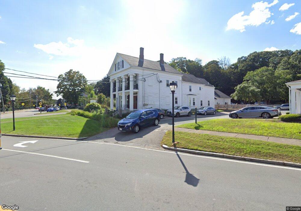
49 Eliot St Natick, MA 01760
Estimated Value: $3,338,003
3
Beds
1
Bath
8,886
Sq Ft
$376/Sq Ft
Est. Value
About This Home
This home is located at 49 Eliot St, Natick, MA 01760 and is currently estimated at $3,338,003, approximately $375 per square foot. 49 Eliot St is a home located in Middlesex County with nearby schools including Natick High School, Memorial Elementary School, and J F Kennedy Middle School.
Ownership History
Date
Name
Owned For
Owner Type
Purchase Details
Closed on
Jan 16, 2018
Sold by
6-8 Pleasant Street Rt
Bought by
6-8 Pleasant Street Rt
Current Estimated Value
Purchase Details
Closed on
Aug 5, 1999
Sold by
Bailey House Rt
Bought by
49-51 Eliot Street T
Home Financials for this Owner
Home Financials are based on the most recent Mortgage that was taken out on this home.
Original Mortgage
$752,000
Interest Rate
7.54%
Mortgage Type
Commercial
Create a Home Valuation Report for This Property
The Home Valuation Report is an in-depth analysis detailing your home's value as well as a comparison with similar homes in the area
Home Values in the Area
Average Home Value in this Area
Purchase History
| Date | Buyer | Sale Price | Title Company |
|---|---|---|---|
| 6-8 Pleasant Street Rt | -- | -- | |
| 49-51 Eliot Street T | $940,000 | -- |
Source: Public Records
Mortgage History
| Date | Status | Borrower | Loan Amount |
|---|---|---|---|
| Previous Owner | 49-51 Eliot Street T | $752,000 | |
| Closed | 49-51 Eliot Street T | $100,000 |
Source: Public Records
Tax History
| Year | Tax Paid | Tax Assessment Tax Assessment Total Assessment is a certain percentage of the fair market value that is determined by local assessors to be the total taxable value of land and additions on the property. | Land | Improvement |
|---|---|---|---|---|
| 2025 | $16,510 | $1,380,400 | $760,200 | $620,200 |
| 2024 | $16,924 | $1,380,400 | $710,100 | $670,300 |
| 2023 | $17,448 | $1,380,400 | $629,500 | $750,900 |
| 2022 | $18,415 | $1,380,400 | $495,200 | $885,200 |
| 2021 | $19,309 | $1,418,700 | $475,200 | $943,500 |
| 2020 | $19,309 | $1,418,700 | $475,200 | $943,500 |
| 2019 | $18,032 | $1,418,700 | $475,200 | $943,500 |
| 2018 | $18,340 | $1,405,400 | $452,500 | $952,900 |
| 2017 | $17,391 | $1,289,200 | $404,700 | $884,500 |
| 2016 | $16,622 | $1,224,900 | $404,700 | $820,200 |
| 2015 | $16,088 | $1,164,100 | $404,700 | $759,400 |
Source: Public Records
Map
Nearby Homes
- 207 Union St Unit 207
- 47 Eliot St
- 57 Eliot St
- 57 Eliot St Unit 3
- 13 Eliot St Unit 6
- 201 Union St
- 201 Union St Unit 1
- 61 Eliot St Unit 1
- 61 Eliot St Unit 2
- 61 Eliot St
- 56R Eliot St
- 56 Eliot St Unit B
- 56 Eliot St Unit C
- 56 Eliot St
- 56 Eliot St Unit 2
- 199 Union St
- 2 Pleasant St Unit 2
- 52 Eliot St
- 200 Union St
- 50 Eliot St
Your Personal Tour Guide
Ask me questions while you tour the home.