Estimated Value: $357,000 - $387,000
3
Beds
2
Baths
1,996
Sq Ft
$186/Sq Ft
Est. Value
About This Home
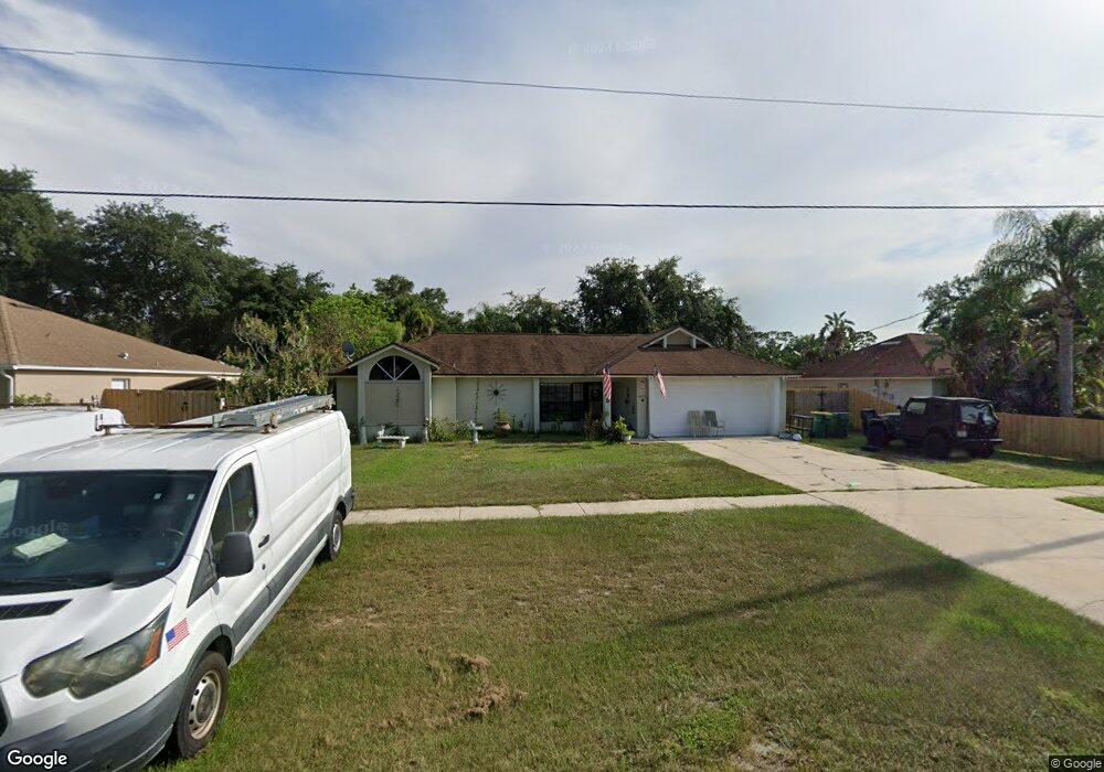
This home is located at 4919 Falcon Blvd, Cocoa, FL 32927 and is currently estimated at $371,626, approximately $186 per square foot. 4919 Falcon Blvd is a home located in Brevard County with nearby schools including Atlantis Elementary School, Space Coast Junior/Senior High School, and Sculptor Charter School.
Ownership History
Date
Name
Owned For
Owner Type
Purchase Details
Closed on
Dec 20, 2024
Sold by
Adams Christine
Bought by
Adams Michael E
Current Estimated Value
Purchase Details
Closed on
Aug 27, 2018
Sold by
Adams Michael E and Trust 4919
Bought by
Adams Christine
Purchase Details
Closed on
Mar 13, 2017
Sold by
Adams Michael E
Bought by
Adams Christine
Purchase Details
Closed on
Nov 15, 2011
Sold by
Rich Dwight
Bought by
Adams Michael E and Trust #4919
Purchase Details
Closed on
May 7, 2001
Sold by
Wentworth Michael J
Bought by
Hill Gladys B and Hill Morton M
Purchase Details
Closed on
Mar 24, 1999
Sold by
Wentworth Michael J and Wentworth Terri T
Bought by
Wentworth Michael J
Create a Home Valuation Report for This Property
The Home Valuation Report is an in-depth analysis detailing your home's value as well as a comparison with similar homes in the area
Home Values in the Area
Average Home Value in this Area
Purchase History
| Date | Buyer | Sale Price | Title Company |
|---|---|---|---|
| Adams Michael E | $50,000 | None Listed On Document | |
| Adams Christine | -- | Federal Title Insurance Agen | |
| Adams Christine | -- | None Available | |
| Adams Michael E | $23,000 | None Available | |
| Hill Gladys B | $129,500 | -- | |
| Wentworth Michael J | -- | -- |
Source: Public Records
Tax History Compared to Growth
Tax History
| Year | Tax Paid | Tax Assessment Tax Assessment Total Assessment is a certain percentage of the fair market value that is determined by local assessors to be the total taxable value of land and additions on the property. | Land | Improvement |
|---|---|---|---|---|
| 2025 | $4,423 | $299,670 | -- | -- |
| 2024 | $4,235 | $314,320 | -- | -- |
| 2023 | $4,235 | $299,290 | $0 | $0 |
| 2022 | $3,841 | $285,570 | $0 | $0 |
| 2021 | $3,490 | $215,120 | $42,000 | $173,120 |
| 2020 | $3,197 | $191,480 | $40,000 | $151,480 |
| 2019 | $3,171 | $187,620 | $35,000 | $152,620 |
| 2018 | $3,045 | $173,800 | $27,000 | $146,800 |
| 2017 | $2,785 | $158,600 | $24,000 | $134,600 |
| 2016 | $2,624 | $138,070 | $18,000 | $120,070 |
| 2015 | $2,530 | $118,890 | $15,000 | $103,890 |
| 2014 | $2,332 | $108,090 | $11,000 | $97,090 |
Source: Public Records
Map
Nearby Homes
- 4859 Horton St
- 7155 Export Ave
- 7035 Jasmine Ave
- 6840 Anecia Ave
- 7275 Durban Ave
- 5090 Market St
- 4760 Ivan St
- 5155 Mayflower St
- 7315 Darien Rd
- 7302 Bumelia Dr
- 5170 Everett St
- 6735 Grissom Pkwy
- 7310 Joshua Place
- 7160 Carlowe Ave
- 6980 Bright Ave
- 7065 Bright Ave
- 7545 Fringe Place
- 4390 Everglades St
- 7020 Ackerman Ave
- 4635 Alfred St
- 4927 Falcon Blvd
- 4932 Patricia St
- 4924 Patricia St
- 4935 Falcon Blvd
- 4895 Falcon Blvd
- 4940 Patricia St
- 4916 Patricia St
- 4910 Falcon Blvd
- 4918 Falcon Blvd
- 4945 Falcon Blvd
- 4887 Falcon Blvd
- 4948 Patricia St
- 4934 Falcon Blvd
- 4908 Patricia St
- 4795 Cinema St
- 4927 Patricia St
- 4951 Falcon Blvd
- 4956 Patricia St
- 4790 Cinema St
- 4911 Patricia St