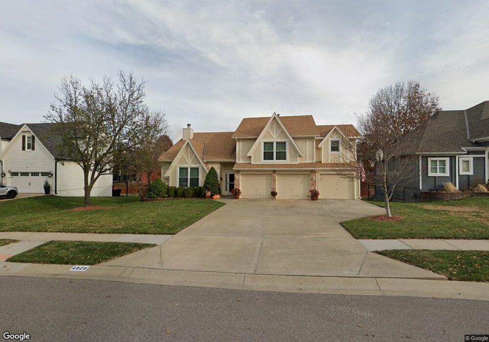
4929 Anderson St Shawnee, KS 66226
Estimated Value: $408,000 - $454,327
4
Beds
2
Baths
1,903
Sq Ft
$231/Sq Ft
Est. Value
About This Home
This home is located at 4929 Anderson St, Shawnee, KS 66226 and is currently estimated at $439,832, approximately $231 per square foot. 4929 Anderson St is a home located in Johnson County with nearby schools including Prairie Ridge Elementary School, Monticello Trails Middle School, and Mill Valley High School.
Ownership History
Date
Name
Owned For
Owner Type
Purchase Details
Closed on
Oct 8, 2007
Sold by
Hemenway Robert B and Hemenway Barbara D
Bought by
Snyder Kari P and Snyder Neatha S
Current Estimated Value
Purchase Details
Closed on
Jan 9, 2002
Sold by
Bertrand Robert S
Bought by
Hemenway Robert B and Hemenway Barbara D
Home Financials for this Owner
Home Financials are based on the most recent Mortgage that was taken out on this home.
Original Mortgage
$161,955
Interest Rate
7.03%
Create a Home Valuation Report for This Property
The Home Valuation Report is an in-depth analysis detailing your home's value as well as a comparison with similar homes in the area
Home Values in the Area
Average Home Value in this Area
Purchase History
| Date | Buyer | Sale Price | Title Company |
|---|---|---|---|
| Snyder Kari P | -- | First American Title Ins Co | |
| Hemenway Robert B | -- | Security Land Title Company |
Source: Public Records
Mortgage History
| Date | Status | Borrower | Loan Amount |
|---|---|---|---|
| Previous Owner | Hemenway Robert B | $161,955 |
Source: Public Records
Tax History Compared to Growth
Tax History
| Year | Tax Paid | Tax Assessment Tax Assessment Total Assessment is a certain percentage of the fair market value that is determined by local assessors to be the total taxable value of land and additions on the property. | Land | Improvement |
|---|---|---|---|---|
| 2024 | $5,452 | $46,908 | $8,527 | $38,381 |
| 2023 | $5,301 | $45,091 | $8,527 | $36,564 |
| 2022 | $4,789 | $39,917 | $7,412 | $32,505 |
| 2021 | $4,620 | $36,996 | $7,412 | $29,584 |
| 2020 | $4,329 | $34,339 | $6,742 | $27,597 |
| 2019 | $4,177 | $32,649 | $5,863 | $26,786 |
| 2018 | $3,953 | $30,613 | $5,863 | $24,750 |
| 2017 | $3,877 | $29,291 | $5,095 | $24,196 |
| 2016 | $3,774 | $28,163 | $4,846 | $23,317 |
| 2015 | $3,614 | $26,530 | $4,846 | $21,684 |
| 2013 | -- | $24,874 | $4,846 | $20,028 |
Source: Public Records
Map
Nearby Homes
- 5005 Hilltop Dr
- 22625 W 49th St
- 22714 W 49th St
- 22910 W 51st St
- 22014 W 51st St
- 5116 Payne St
- 22115 W 51st Terrace
- 5206 Round Prairie St
- 22912 W 47th Terrace
- 22611 W 46th Terrace
- 4638 Aminda St
- 22014 W 47th Terrace
- 5408 Aminda St
- 5402 Roundtree St
- 21804 W 52nd Terrace
- 5221 Meadow View Dr
- 21525 W 51st St
- 21624 W 53rd Terrace
- 5531 Hilltop Dr
- 4420 Anderson St
- 4925 Anderson St
- 4933 Anderson St
- 5002 Mccoy St
- 5001 Anderson St
- 5008 Mccoy St
- 4921 Anderson St
- 4938 Mccoy St
- 22605 W 49th Terrace
- 5014 Mccoy St
- 4934 Mccoy St
- 22608 W 50th St
- 5005 Anderson St
- 4917 Anderson St
- 22602 W 49th Terrace
- 22609 W 49th Terrace
- 5020 Mccoy St
- 4930 Mccoy St
- 22606 W 49th Terrace
- 5009 Anderson St
- 22612 W 50th St