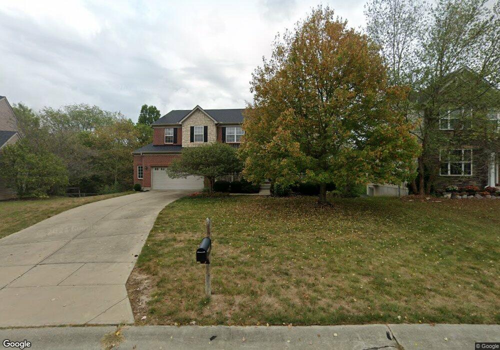
4941 Sundance Dr Independence, KY 41051
Estimated Value: $450,441 - $512,000
4
Beds
3
Baths
3,328
Sq Ft
$145/Sq Ft
Est. Value
About This Home
This home is located at 4941 Sundance Dr, Independence, KY 41051 and is currently estimated at $483,860, approximately $145 per square foot. 4941 Sundance Dr is a home located in Kenton County with nearby schools including Simon Kenton High School and St. Cecilia Catholic School.
Ownership History
Date
Name
Owned For
Owner Type
Purchase Details
Closed on
Sep 19, 2005
Sold by
The Ryland Group Inc
Bought by
Price R Preston and Price Debra J
Current Estimated Value
Home Financials for this Owner
Home Financials are based on the most recent Mortgage that was taken out on this home.
Original Mortgage
$232,200
Outstanding Balance
$123,211
Interest Rate
5.72%
Mortgage Type
Fannie Mae Freddie Mac
Estimated Equity
$360,649
Purchase Details
Closed on
Feb 22, 2005
Sold by
Great Development Properties Inc
Bought by
The Ryland Group Inc
Create a Home Valuation Report for This Property
The Home Valuation Report is an in-depth analysis detailing your home's value as well as a comparison with similar homes in the area
Home Values in the Area
Average Home Value in this Area
Purchase History
| Date | Buyer | Sale Price | Title Company |
|---|---|---|---|
| Price R Preston | $290,309 | Ryland Title Company | |
| The Ryland Group Inc | $1,215,375 | Ryland Title Company |
Source: Public Records
Mortgage History
| Date | Status | Borrower | Loan Amount |
|---|---|---|---|
| Open | Price R Preston | $232,200 |
Source: Public Records
Tax History Compared to Growth
Tax History
| Year | Tax Paid | Tax Assessment Tax Assessment Total Assessment is a certain percentage of the fair market value that is determined by local assessors to be the total taxable value of land and additions on the property. | Land | Improvement |
|---|---|---|---|---|
| 2024 | $3,958 | $323,100 | $35,000 | $288,100 |
| 2023 | $4,078 | $323,100 | $35,000 | $288,100 |
| 2022 | $4,128 | $323,100 | $35,000 | $288,100 |
| 2021 | $4,190 | $323,100 | $35,000 | $288,100 |
| 2020 | $3,852 | $290,300 | $30,000 | $260,300 |
| 2019 | $3,862 | $290,300 | $30,000 | $260,300 |
| 2018 | $3,883 | $290,300 | $30,000 | $260,300 |
| 2017 | $3,776 | $290,300 | $30,000 | $260,300 |
| 2015 | $3,675 | $290,300 | $34,700 | $255,600 |
| 2014 | $3,623 | $290,300 | $34,700 | $255,600 |
Source: Public Records
Map
Nearby Homes
- 4879 Open Meadow Dr
- 4910 Fowler Creek Rd
- 4758 Fowler Creek Rd
- 2215 Scheper Ct
- 3956 Piperidge Way
- 3952 Piperidge Way
- 10448 Canberra Dr
- 10447 Canberra Dr
- 3850 Sherbourne Dr
- 3852 Sherbourne Dr
- 1479 Rising Ridge Dr
- 1365 Cairns Ct
- 64 Sylvan Dr
- 114 Sylvan Dr
- QUENTIN Plan at Sherbourne - Sherbourne Summits
- SHELBURN Plan at Sherbourne - Sherbourne Summits
- 7 Waterside Way
- 5118 Dana Harvey Ln
- 143 Tando Way
- 10363 Canberra Dr
- 4937 Sundance Dr
- 4945 Sundance Dr
- 4933 Sundance Dr
- 4949 Sundance Dr
- 4949 Sundance Dr Unit 229
- 4944 Sundance Dr
- 4934 Sundance Dr
- 4929 Sundance Dr
- 4953 Sundance Dr
- 4952 Sundance Dr
- 4930 Sundance Dr
- 4925 Sundance Dr
- 2149 Golden Valley Dr
- 2138 Starlight Ln
- 2138 Starlight Ln Unit Lot 189
- 4926 Sundance Dr
- 4957 Sundance Dr
- 4956 Sundance Dr
- 2153 Golden Valley Dr
- 2131 Golden Valley Dr