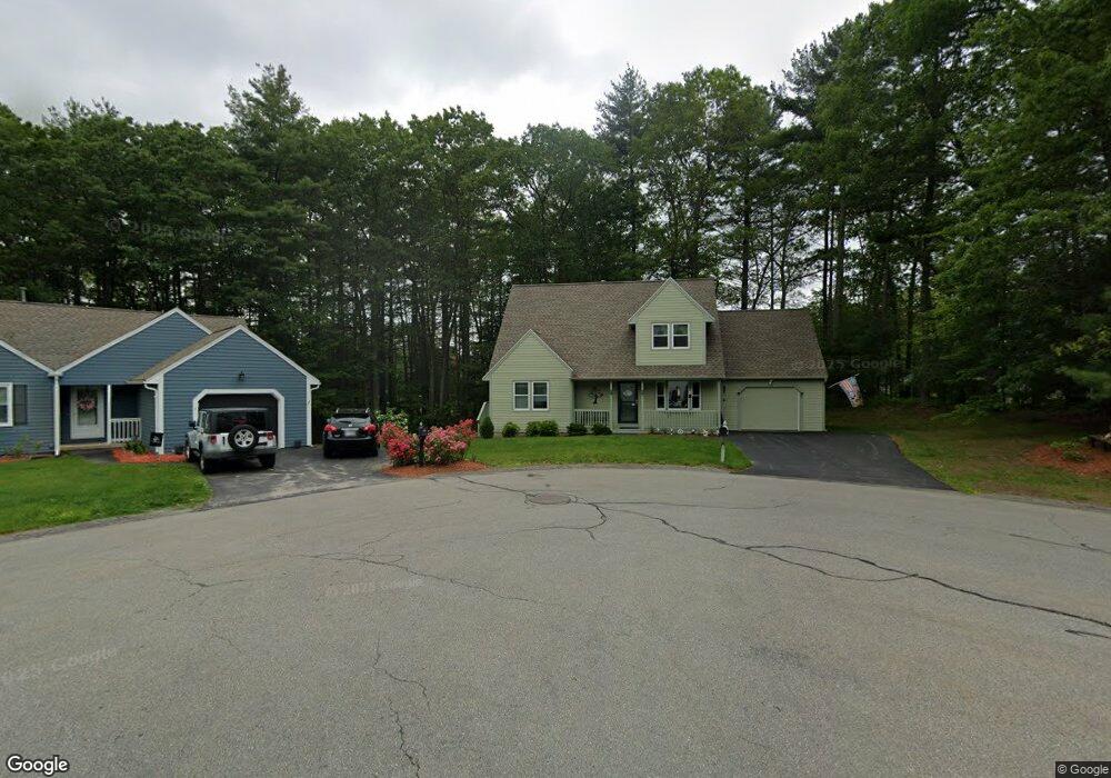
5 Logan Ct Hudson, NH 03051
Estimated Value: $396,000 - $509,000
3
Beds
1
Bath
1,711
Sq Ft
$268/Sq Ft
Est. Value
About This Home
This home is located at 5 Logan Ct, Hudson, NH 03051 and is currently estimated at $459,146, approximately $268 per square foot. 5 Logan Ct is a home located in Hillsborough County with nearby schools including Tabernacle Christian School, White Wing School, and Clearway High School.
Ownership History
Date
Name
Owned For
Owner Type
Purchase Details
Closed on
Sep 25, 2024
Sold by
Paul M & L I Lacasse Irt and Lacasse
Bought by
Paul M & L I Lacasse Ret and Lacasse
Current Estimated Value
Purchase Details
Closed on
Jul 17, 2012
Sold by
Lacasse Paul M and Lacasse Louise I
Bought by
Paul M & L I Lacasse Irt and Lacasse
Purchase Details
Closed on
May 18, 1995
Bought by
Lacasse Paul M and Lacasse Louise I
Create a Home Valuation Report for This Property
The Home Valuation Report is an in-depth analysis detailing your home's value as well as a comparison with similar homes in the area
Home Values in the Area
Average Home Value in this Area
Purchase History
| Date | Buyer | Sale Price | Title Company |
|---|---|---|---|
| Paul M & L I Lacasse Ret | -- | None Available | |
| Paul M & L I Lacasse Ret | -- | None Available | |
| Paul M & L I Lacasse Irt | -- | -- | |
| Paul M&L I Lacasse Irt | -- | -- | |
| Lacasse Paul M | $106,900 | -- |
Source: Public Records
Mortgage History
| Date | Status | Borrower | Loan Amount |
|---|---|---|---|
| Previous Owner | Lacasse Paul M | $97,000 |
Source: Public Records
Tax History Compared to Growth
Tax History
| Year | Tax Paid | Tax Assessment Tax Assessment Total Assessment is a certain percentage of the fair market value that is determined by local assessors to be the total taxable value of land and additions on the property. | Land | Improvement |
|---|---|---|---|---|
| 2024 | $5,743 | $349,100 | $0 | $349,100 |
| 2023 | $5,474 | $349,100 | $0 | $349,100 |
| 2022 | $5,052 | $343,900 | $0 | $343,900 |
| 2021 | $5,697 | $262,900 | $0 | $262,900 |
| 2020 | $5,637 | $263,800 | $0 | $263,800 |
| 2019 | $5,350 | $263,800 | $0 | $263,800 |
| 2018 | $5,302 | $263,800 | $0 | $263,800 |
| 2017 | $5,202 | $263,800 | $0 | $263,800 |
| 2016 | $4,948 | $225,200 | $0 | $225,200 |
| 2015 | $4,786 | $225,200 | $0 | $225,200 |
| 2014 | $4,691 | $225,200 | $0 | $225,200 |
| 2013 | $4,636 | $225,500 | $0 | $225,500 |
Source: Public Records
Map
Nearby Homes
- 36 Sutherland Dr
- 11 Scottsdale Dr
- 9 Sunshine Dr Unit A
- 3 Robin Dr
- 16 Evergreen Dr
- 10 Wagner Way
- 11 Cardinal Dr
- 319 Fox Run Rd
- 152 Ferry St
- 27 Alvirne Dr
- 73 Ferry St
- 40B Brackett Ln
- 22 Oliver Dr
- 27 Amanda Dr
- 29 Derry St
- 434 Abbott Farm Ln
- 312 Abbott Farm Ln
- 31 Shadowbrook Dr
- 15 Intervale Ct
- 49 Cobblestone Dr
- 6 Logan Ct
- 6 Logan Ct Unit 20
- 4 Logan Ct
- 4 Logan Ct Unit 19
- 2 Logan Ct
- 1 Logan Ct
- 38 Sutherland Dr
- 24 Scottsdale Dr
- 40 Sutherland Dr
- 22 Scottsdale Dr
- 34 Sutherland Dr
- 35 Glasgow Cir
- 42 Glasgow Cir
- 38 Glasgow Cir
- 25 Glasgow Cir
- 38 Glasgow Cir Unit 58
- 13 Scottsdale Dr
- 53 Glasgow Cir
- 46 Glasgow Cir
- 26 Glasgow Cir