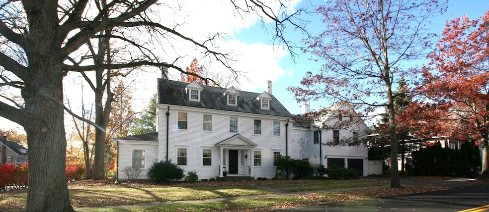
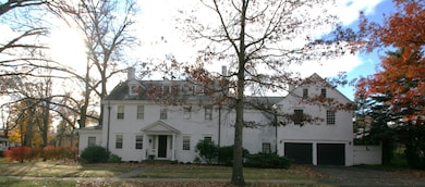


5 Oakland St Bristol, CT 06010
Federal Hill NeighborhoodEstimated payment $2,970/month
Highlights
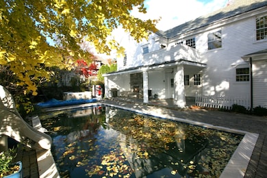
- Concrete Pool
- Attic
- Bonus Room
- Colonial Architecture
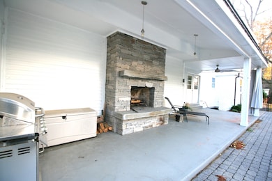
- 1 Fireplace
- Balcony
About This Home
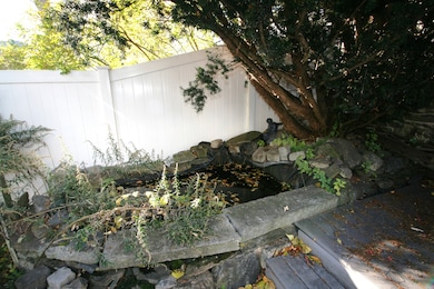
Discover a timeless masterpiece in the heart of the distinguished Federal Hill Historic District, where classic elegance meets architectural grandeur. This magnificent 5-bedroom, Center Hall Colonial home offers a rare opportunity to own a piece of history, combining serene, established surroundings with the vibrant community feel of one of the city's most sought-after neighborhoods. Step into the grand, symmetrical center hall that provides a striking first impression and defines the balanced floor plan, with formal living spaces on either side. Much of the original charm has been preserved, featuring authentic period details that evoke a sense of heritage and sophistication. Step outside to a private oasis with inground pool, outside shower, hot tub and a unique waterfall pool that can be set to salt water or chlorine. And the finishing touch is the large built-in fireplace to create the ambiance that will capture memories for years to come... There are a few things left for you to finish up that will skyrocket your equity.... Like the suite above the garage that is framed, wired and plumbed and the basement that has additional potential.
Listing Agent
Integrity Real Estate Brokerage Phone: (860) 485-4974 License #REB.0757256 Listed on: 11/07/2025
Home Details
Home Type
- Single Family
Est. Annual Taxes
- $8,892
Year Built
- Built in 1910
Lot Details
- 0.26 Acre Lot
- Property is zoned R-15
Home Design
- Colonial Architecture
- Stone Foundation
- Frame Construction
- Slate Roof
- Clap Board Siding
- Cedar Siding
Interior Spaces
- 3,107 Sq Ft Home
- 1 Fireplace
- Entrance Foyer
- Bonus Room
- Concrete Flooring
- Laundry on main level
Kitchen
- Electric Range
- Dishwasher
- Disposal
Bedrooms and Bathrooms
- 5 Bedrooms
- Bathroom Rough-In
Attic
- Walk-In Attic
- Partially Finished Attic
Unfinished Basement
- Walk-Out Basement
- Basement Fills Entire Space Under The House
Parking
- 2 Car Garage
- Private Driveway
Pool
- Concrete Pool
- Heated In Ground Pool
- Vinyl Pool
- Spa
Outdoor Features
- Balcony
- Covered Deck
- Breezeway
- Rain Gutters
Location
- Property is near shops
Schools
- Ellen P. Hubbell Elementary School
- Chippens Hill Middle School
- Bristol Eastern High School
Utilities
- Zoned Heating and Cooling
- Radiator
- Baseboard Heating
- Heating System Uses Oil
- Hydro-Air Heating System
- 60 Gallon+ Oil Water Heater
- Fuel Tank Located in Basement
Listing and Financial Details
- Assessor Parcel Number 477155
Map
Home Values in the Area
Average Home Value in this Area
Tax History
| Year | Tax Paid | Tax Assessment Tax Assessment Total Assessment is a certain percentage of the fair market value that is determined by local assessors to be the total taxable value of land and additions on the property. | Land | Improvement |
|---|---|---|---|---|
| 2025 | $8,892 | $263,480 | $34,440 | $229,040 |
| 2024 | $8,392 | $263,480 | $34,440 | $229,040 |
| 2023 | $7,997 | $263,480 | $34,440 | $229,040 |
| 2022 | $7,659 | $199,710 | $26,040 | $173,670 |
| 2021 | $7,659 | $199,710 | $26,040 | $173,670 |
| 2020 | $7,659 | $199,710 | $26,040 | $173,670 |
| 2019 | $8,377 | $220,150 | $26,040 | $194,110 |
| 2018 | $8,119 | $220,150 | $26,040 | $194,110 |
| 2017 | $7,347 | $203,910 | $37,240 | $166,670 |
| 2016 | $7,347 | $203,910 | $37,240 | $166,670 |
| 2015 | $7,057 | $203,910 | $37,240 | $166,670 |
| 2014 | $7,057 | $203,910 | $37,240 | $166,670 |
Property History
| Date | Event | Price | List to Sale | Price per Sq Ft |
|---|---|---|---|---|
| 11/07/2025 11/07/25 | For Sale | $425,000 | -- | $137 / Sq Ft |
Purchase History
| Date | Type | Sale Price | Title Company |
|---|---|---|---|
| Executors Deed | $150,000 | -- |
Mortgage History
| Date | Status | Loan Amount | Loan Type |
|---|---|---|---|
| Open | $57,400 | No Value Available | |
| Open | $142,500 | No Value Available |
Source: SmartMLS
MLS Number: 24138929
APN: BRIS-000025A-000000-000074
Disclaimer: Certain information contained herein is derived from information provided by parties other than Homes.com. All information provided is deemed reliable, but is not guaranteed to be accurate and should be independently verified.
![]() IDX information is provided exclusively for personal, non-commercial use, and may not be used for any purpose other than to identify prospective properties consumers may be interested in purchasing. Information is deemed reliable but not guaranteed.
IDX information is provided exclusively for personal, non-commercial use, and may not be used for any purpose other than to identify prospective properties consumers may be interested in purchasing. Information is deemed reliable but not guaranteed.
- 35 Broadview St
- 111 Stearns St
- 172 Oakland St
- 17 Grove St Unit 3RD
- 157 High St
- 38 Prospect Place
- 213 Summer St
- 207 Summer St
- 301 Queen St
- 36 Richmond Place
- 309 Queen St
- 20 Lincoln St
- 29 Lincoln Place
- 10 Henry St
- 58 Lincoln St
- 41 Pardee St
- 220 Blakeslee St Unit 220
- 23 Daniel Rd
- 68 Center St
- 39 Williams St
- 42 Oakland St Unit 2
- 111 Stearns St
- 101 Stearns St
- 18 Walnut St
- 46 Stearns St Unit 2L
- 46 Stearns St
- 46 Stearns St
- 138 Federal St
- 125 High St Unit 125 FL 2
- 183 Prospect St
- 245 Oakland St
- 133 North St
- 22 High St
- 42 Summer St Unit 5
- 42 Summer St Unit 4
- 67 Burlington Ave Unit 69
- 200 Blakeslee St
- 38 Prospect St Unit 38
- 26 Dwight St Unit 3rd floor
- 100 N Main St Unit 411
