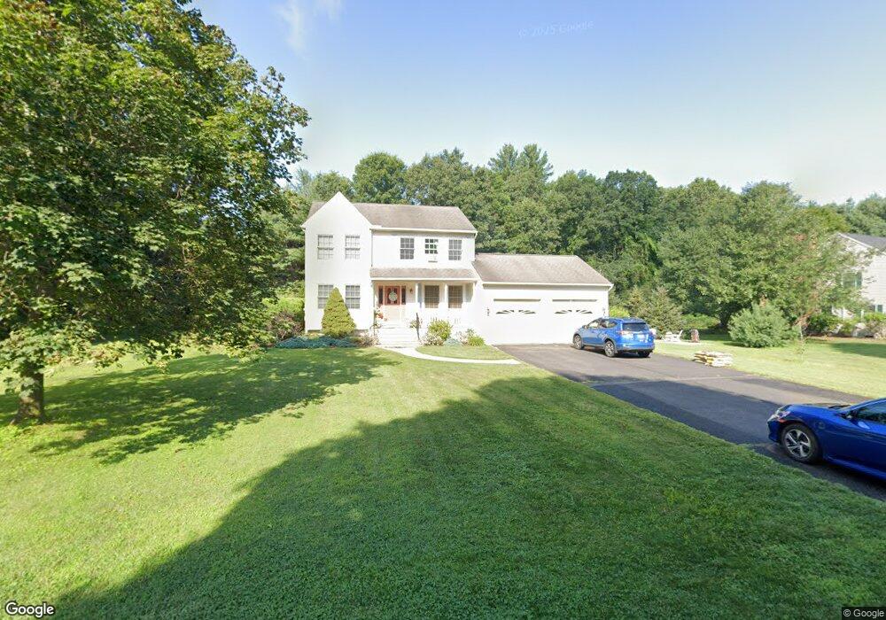
5 Pine Ct Sunderland, MA 01375
Estimated Value: $512,181 - $617,000
3
Beds
3
Baths
1,962
Sq Ft
$285/Sq Ft
Est. Value
About This Home
This home is located at 5 Pine Ct, Sunderland, MA 01375 and is currently estimated at $559,295, approximately $285 per square foot. 5 Pine Ct is a home located in Franklin County with nearby schools including Sunderland Elementary School and Frontier Regional School.
Ownership History
Date
Name
Owned For
Owner Type
Purchase Details
Closed on
Jun 29, 2000
Sold by
Majewski Daniel M
Bought by
Laurens Marc R and Laurens Sacco-Laurens B
Current Estimated Value
Home Financials for this Owner
Home Financials are based on the most recent Mortgage that was taken out on this home.
Original Mortgage
$239,900
Outstanding Balance
$88,031
Interest Rate
8.59%
Mortgage Type
Purchase Money Mortgage
Estimated Equity
$471,264
Purchase Details
Closed on
Jun 27, 1997
Sold by
John A Mokrzecky Ret and Mokrzecky John A
Bought by
Majewski Daniel J
Create a Home Valuation Report for This Property
The Home Valuation Report is an in-depth analysis detailing your home's value as well as a comparison with similar homes in the area
Home Values in the Area
Average Home Value in this Area
Purchase History
| Date | Buyer | Sale Price | Title Company |
|---|---|---|---|
| Laurens Marc R | $191,000 | -- | |
| Majewski Daniel J | $44,900 | -- |
Source: Public Records
Mortgage History
| Date | Status | Borrower | Loan Amount |
|---|---|---|---|
| Open | Majewski Daniel J | $239,900 |
Source: Public Records
Tax History
| Year | Tax Paid | Tax Assessment Tax Assessment Total Assessment is a certain percentage of the fair market value that is determined by local assessors to be the total taxable value of land and additions on the property. | Land | Improvement |
|---|---|---|---|---|
| 2025 | $61 | $472,300 | $123,500 | $348,800 |
| 2024 | $6,206 | $472,300 | $123,500 | $348,800 |
| 2023 | $5,693 | $444,800 | $112,200 | $332,600 |
| 2022 | $5,757 | $391,600 | $96,200 | $295,400 |
| 2021 | $5,609 | $362,100 | $89,200 | $272,900 |
| 2020 | $5,563 | $360,300 | $89,200 | $271,100 |
| 2019 | $5,384 | $351,200 | $86,600 | $264,600 |
| 2018 | $5,066 | $337,700 | $83,100 | $254,600 |
| 2017 | $4,801 | $334,800 | $83,100 | $251,700 |
| 2016 | $4,905 | $334,600 | $81,500 | $253,100 |
| 2015 | $4,788 | $334,600 | $81,500 | $253,100 |
| 2014 | $4,660 | $333,300 | $81,500 | $251,800 |
Source: Public Records
Map
Nearby Homes
- 13 Shattuck Rd
- 34 Comins Rd
- 274 Sunderland Rd
- 10 Depot Rd
- 200 Long Plain Rd
- 113 Juggler Meadow Rd
- 208 Pine St Unit 53
- 281 Leverett Rd
- 43 Morgan Cir
- 33 Bridge St
- 79 State Rd
- 185 Cherry Ln
- Lot A Kingman Rd
- 277 River Dr
- 471 Flat Hills Rd
- 36 Swamp Rd
- 0 Straits Rd
- 14 Sugarloaf St
- 0 Greenfield Rd Unit 73472322
- 136 Main St
- 9 Pine Ct
- 196 Plumtree Rd
- 188 Plumtree Rd
- 10 Pine Ct
- 187 Plumtree Rd
- 189 Plumtree Rd
- 19 Pine Ct
- 202 Plumtree Rd
- 195 Plumtree Rd
- 179 Plumtree Rd
- 184 Plumtree Rd
- 201 Plumtree Rd
- 198 Plumtree Rd
- 191 Plumtree Rd
- 208 Plumtree Rd
- 175 Plumtree Rd
- 186 Plumtree Rd
- 207 Plumtree Rd
- 167 Plumtree Rd
- 214 Plumtree Rd
Your Personal Tour Guide
Ask me questions while you tour the home.