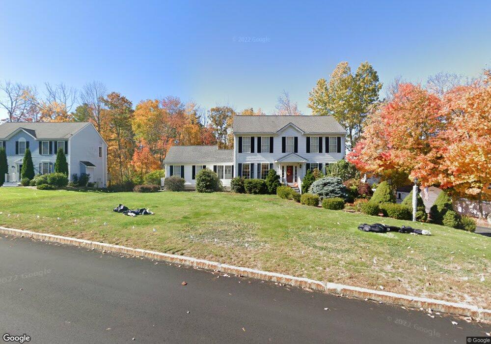
50 Autumn Run Hooksett, NH 03106
Estimated Value: $695,000 - $726,000
4
Beds
4
Baths
2,350
Sq Ft
$304/Sq Ft
Est. Value
About This Home
This home is located at 50 Autumn Run, Hooksett, NH 03106 and is currently estimated at $713,427, approximately $303 per square foot. 50 Autumn Run is a home located in Merrimack County with nearby schools including Fred C. Underhill School, Hooksett Memorial School, and David R. Cawley Middle School.
Ownership History
Date
Name
Owned For
Owner Type
Purchase Details
Closed on
Oct 24, 2000
Sold by
Cusick Ray A and Cusick Heidy R
Bought by
Louiselle John B and Louiselle Anne M
Current Estimated Value
Home Financials for this Owner
Home Financials are based on the most recent Mortgage that was taken out on this home.
Original Mortgage
$203,900
Outstanding Balance
$74,147
Interest Rate
7.88%
Mortgage Type
Purchase Money Mortgage
Estimated Equity
$639,280
Purchase Details
Closed on
Nov 29, 1999
Sold by
Advanced Contr Corp
Bought by
Cusick Ray A and Cusick Heidy R
Home Financials for this Owner
Home Financials are based on the most recent Mortgage that was taken out on this home.
Original Mortgage
$211,500
Interest Rate
7.77%
Mortgage Type
Purchase Money Mortgage
Create a Home Valuation Report for This Property
The Home Valuation Report is an in-depth analysis detailing your home's value as well as a comparison with similar homes in the area
Home Values in the Area
Average Home Value in this Area
Purchase History
| Date | Buyer | Sale Price | Title Company |
|---|---|---|---|
| Louiselle John B | $254,900 | -- | |
| Cusick Ray A | $65,000 | -- |
Source: Public Records
Mortgage History
| Date | Status | Borrower | Loan Amount |
|---|---|---|---|
| Open | Cusick Ray A | $203,900 | |
| Previous Owner | Cusick Ray A | $211,500 |
Source: Public Records
Tax History Compared to Growth
Tax History
| Year | Tax Paid | Tax Assessment Tax Assessment Total Assessment is a certain percentage of the fair market value that is determined by local assessors to be the total taxable value of land and additions on the property. | Land | Improvement |
|---|---|---|---|---|
| 2024 | $10,573 | $623,400 | $160,900 | $462,500 |
| 2023 | $9,962 | $623,400 | $160,900 | $462,500 |
| 2022 | $8,413 | $349,800 | $102,400 | $247,400 |
| 2021 | $7,773 | $349,800 | $102,400 | $247,400 |
| 2020 | $7,874 | $349,800 | $102,400 | $247,400 |
| 2019 | $7,538 | $349,800 | $102,400 | $247,400 |
| 2018 | $7,738 | $349,800 | $102,400 | $247,400 |
| 2017 | $7,693 | $287,700 | $100,800 | $186,900 |
| 2016 | $7,592 | $287,700 | $100,800 | $186,900 |
| 2015 | $4,637 | $287,700 | $100,800 | $186,900 |
| 2014 | $4,448 | $287,700 | $100,800 | $186,900 |
| 2013 | -- | $287,700 | $100,800 | $186,900 |
Source: Public Records
Map
Nearby Homes
- 155 Londonderry Turnpike
- 28 Auburn Rd
- 13 Johns Dr
- 4 Forest Hills Rd
- 15 Johns Dr
- 103 Mammoth Rd
- 18 Cindy Dr
- 45 Leonard Ave
- 286B Londonderry Turnpike Unit A
- 22 Harmony Ln
- 69 Heather Cir
- 6 Gailor Ln
- 27 Martins Ferry Rd
- 5 Shaker Hill Rd
- 125 Laurel Rd Unit 33
- 110 Laurel Rd Unit 31
- 62 Jonathan Ln
- 7 Mulberry Ln
- 30 Laurel Rd
- 215 Patricia Ln