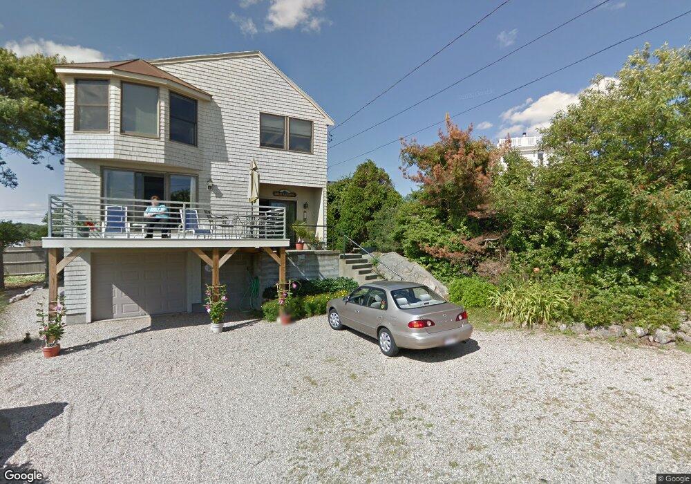
50 Salt Island Rd Gloucester, MA 01930
East Gloucester NeighborhoodEstimated Value: $1,612,000 - $1,957,000
4
Beds
4
Baths
3,048
Sq Ft
$595/Sq Ft
Est. Value
About This Home
This home is located at 50 Salt Island Rd, Gloucester, MA 01930 and is currently estimated at $1,813,928, approximately $595 per square foot. 50 Salt Island Rd is a home located in Essex County with nearby schools including East Gloucester Elementary School, Ralph B O'maley Middle School, and Gloucester High School.
Ownership History
Date
Name
Owned For
Owner Type
Purchase Details
Closed on
Feb 24, 2021
Sold by
Silverman Samuel
Bought by
Samuel L Silverman Ret
Current Estimated Value
Purchase Details
Closed on
Jul 30, 2003
Sold by
Iacono George A
Bought by
Iacono Greg W
Create a Home Valuation Report for This Property
The Home Valuation Report is an in-depth analysis detailing your home's value as well as a comparison with similar homes in the area
Home Values in the Area
Average Home Value in this Area
Purchase History
| Date | Buyer | Sale Price | Title Company |
|---|---|---|---|
| Samuel L Silverman Ret | -- | None Available | |
| Iacono Greg W | -- | -- | |
| Iacono Greg W | -- | -- |
Source: Public Records
Tax History
| Year | Tax Paid | Tax Assessment Tax Assessment Total Assessment is a certain percentage of the fair market value that is determined by local assessors to be the total taxable value of land and additions on the property. | Land | Improvement |
|---|---|---|---|---|
| 2025 | $16,415 | $1,688,800 | $918,000 | $770,800 |
| 2024 | $16,005 | $1,644,900 | $874,100 | $770,800 |
| 2023 | $15,410 | $1,455,100 | $780,700 | $674,400 |
| 2022 | $15,062 | $1,284,100 | $679,100 | $605,000 |
| 2021 | $14,539 | $1,168,700 | $617,200 | $551,500 |
| 2020 | $14,087 | $1,142,500 | $581,900 | $560,600 |
| 2019 | $13,870 | $1,093,000 | $581,900 | $511,100 |
| 2018 | $13,693 | $1,059,000 | $581,900 | $477,100 |
| 2017 | $13,414 | $1,017,000 | $554,100 | $462,900 |
| 2016 | $12,909 | $948,500 | $525,600 | $422,900 |
| 2015 | $12,512 | $916,600 | $525,600 | $391,000 |
Source: Public Records
Map
Nearby Homes
- 25 Salt Island Rd
- 78 Thatcher Rd Unit 6
- 33 Highview Rd
- 26 Marina Dr
- 87 Atlantic Rd Unit 2
- 5 Wise Place
- 175 South St
- 27 Hodgkins Rd
- 30 Chapel St Unit B
- 16 Hodgkins Rd Unit 2
- 197 E Main St Unit 1
- 197 E Main St Unit 2
- 160 Prospect St Unit 3
- 177 Main St
- 10 Oak St Unit 3
- 10 Seaview Rd
- 48 Eden Rd
- 19 Trask St Unit 2
- 34R Summer St
- 73 Rocky Neck Ave Unit 2
- 50A Salt Island Rd
- 9 Naiomi Dr
- 52 Salt Island Rd
- 14 Naiomi Dr
- 7 Naiomi Dr
- 7 Naomi Dr
- 48 Salt Island Rd
- 14 Palfrey Rd
- 54 Salt Island Rd
- 46 Salt Island Rd
- 12 Naiomi Dr
- 5 Naiomi Dr
- 12 Palfrey Rd
- 10 Naiomi Dr
- 10 Palfrey Rd
- 5 Brier Neck Ave
- 49 Salt Island Rd
- 47 Salt Island Rd
- 3 Naiomi Dr
- 45 Salt Island Rd
Your Personal Tour Guide
Ask me questions while you tour the home.