Estimated Value: $388,000 - $437,000
3
Beds
3
Baths
1,419
Sq Ft
$294/Sq Ft
Est. Value
About This Home
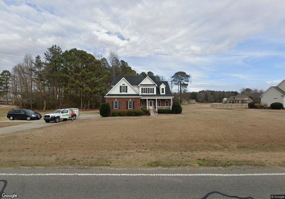
This home is located at 5063 Nc Highway 581, Sims, NC 27880 and is currently estimated at $416,595, approximately $293 per square foot. 5063 Nc Highway 581 is a home located in Wilson County with nearby schools including James Hunt High School, Rock Ridge Elementary School, and Springfield Middle School.
Ownership History
Date
Name
Owned For
Owner Type
Purchase Details
Closed on
May 14, 2024
Sold by
Taylor Pearl R
Bought by
Deufemia Joseph P and Deufemia Nancy H
Current Estimated Value
Home Financials for this Owner
Home Financials are based on the most recent Mortgage that was taken out on this home.
Original Mortgage
$301,000
Outstanding Balance
$295,029
Interest Rate
5%
Mortgage Type
New Conventional
Estimated Equity
$121,566
Purchase Details
Closed on
Nov 28, 2006
Sold by
Letchworth Builders Inc
Bought by
Taylor Eugene R and Taylor Pearl R
Create a Home Valuation Report for This Property
The Home Valuation Report is an in-depth analysis detailing your home's value as well as a comparison with similar homes in the area
Home Values in the Area
Average Home Value in this Area
Purchase History
| Date | Buyer | Sale Price | Title Company |
|---|---|---|---|
| Deufemia Joseph P | $395,000 | None Listed On Document | |
| Taylor Eugene R | $240,000 | None Available |
Source: Public Records
Mortgage History
| Date | Status | Borrower | Loan Amount |
|---|---|---|---|
| Open | Deufemia Joseph P | $301,000 |
Source: Public Records
Tax History Compared to Growth
Tax History
| Year | Tax Paid | Tax Assessment Tax Assessment Total Assessment is a certain percentage of the fair market value that is determined by local assessors to be the total taxable value of land and additions on the property. | Land | Improvement |
|---|---|---|---|---|
| 2025 | $2,513 | $386,574 | $58,893 | $327,681 |
| 2024 | $2,513 | $357,671 | $58,893 | $298,778 |
| 2022 | $0 | $213,349 | $29,223 | $184,126 |
| 2021 | $1,771 | $213,349 | $29,223 | $184,126 |
| 2020 | $1,771 | $213,349 | $29,223 | $184,126 |
| 2019 | $1,771 | $213,349 | $29,223 | $184,126 |
| 2018 | $0 | $213,349 | $29,223 | $184,126 |
| 2017 | $1,771 | $213,349 | $29,223 | $184,126 |
| 2016 | $1,774 | $209,498 | $29,223 | $180,275 |
| 2014 | $1,913 | $230,468 | $43,983 | $186,485 |
Source: Public Records
Map
Nearby Homes
- 5141 Willows Edge Dr
- 5144 Willows Edge Dr
- 5082 Willows Edge Dr
- 5030 Willows Edge Dr
- 8207 Rock Ridge School Rd
- 8320 Bunn Rd
- 8662 Buckhorn Plantation Rd
- 8405 Clearwater Dr
- 8404 Thomas Ct
- 8107 Gentle Breeze Dr
- 8218 Old Raleigh Rd
- 0 Exum Rd
- 9558 Batten Rd
- 0 Boykin Rd
- 0 Brame Rd
- 59 N Movado Trail
- 39 Movado Trail N
- 59 Pagani Dr
- 186 N Movado Trail
- 207 N Movado Trail
- 5063 N Carolina 581
- 5060 Highway Unit 581
- 5060 Nc Highway 581
- 5060 Nc 581 Hwy
- 5060 N Carolina 581
- 5006 Pennington Place
- 5006 Pennington Place Unit 28
- 5062 Nc Highway 581
- 5056 Nc Highway 581
- 5056 Nc Highway 581 Unit 3
- 5067 Nc Highway 581
- 5061 Nc 581 Hwy
- 5061 Nc 581 Hwy Unit 29
- 5008 Pennington Place
- 5058 Nc 581 Hwy
- 5058 Nc 581 Hwy Unit 2
- 0 Pennington Place Unit 1791545
- 5075 Nc Highway 581
- 5075 Nc Highway 581
- 5114 Armetus Rd