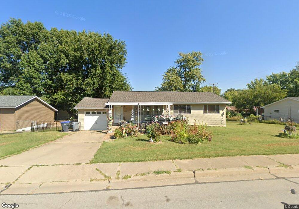
507 Danny Ln O Fallon, MO 63366
Estimated Value: $245,418 - $265,000
3
Beds
1
Bath
1,100
Sq Ft
$231/Sq Ft
Est. Value
About This Home
This home is located at 507 Danny Ln, O Fallon, MO 63366 and is currently estimated at $253,605, approximately $230 per square foot. 507 Danny Ln is a home located in St. Charles County with nearby schools including Joseph L. Mudd Elementary School, Forest Park Elementary School, and Fort Zumwalt North Middle School.
Ownership History
Date
Name
Owned For
Owner Type
Purchase Details
Closed on
Aug 17, 2004
Sold by
Williams Donald G and Williams Denise L
Bought by
Williams Donald G and Williams Denise L
Current Estimated Value
Home Financials for this Owner
Home Financials are based on the most recent Mortgage that was taken out on this home.
Original Mortgage
$63,200
Interest Rate
6%
Mortgage Type
Credit Line Revolving
Purchase Details
Closed on
Dec 18, 1998
Sold by
Dunlap Norma Jean Hershel O
Bought by
Williams Donald G
Home Financials for this Owner
Home Financials are based on the most recent Mortgage that was taken out on this home.
Original Mortgage
$62,525
Interest Rate
6.92%
Mortgage Type
FHA
Create a Home Valuation Report for This Property
The Home Valuation Report is an in-depth analysis detailing your home's value as well as a comparison with similar homes in the area
Home Values in the Area
Average Home Value in this Area
Purchase History
| Date | Buyer | Sale Price | Title Company |
|---|---|---|---|
| Williams Donald G | -- | -- | |
| Williams Donald G | -- | -- |
Source: Public Records
Mortgage History
| Date | Status | Borrower | Loan Amount |
|---|---|---|---|
| Closed | Williams Donald G | $63,200 | |
| Closed | Williams Donald G | $62,525 | |
| Closed | Williams Donald G | $39,800 |
Source: Public Records
Tax History
| Year | Tax Paid | Tax Assessment Tax Assessment Total Assessment is a certain percentage of the fair market value that is determined by local assessors to be the total taxable value of land and additions on the property. | Land | Improvement |
|---|---|---|---|---|
| 2025 | $2,341 | $39,203 | -- | -- |
| 2023 | $2,342 | $35,130 | $0 | $0 |
| 2022 | $2,124 | $29,606 | $0 | $0 |
| 2021 | $2,126 | $29,606 | $0 | $0 |
| 2020 | $1,955 | $26,419 | $0 | $0 |
| 2019 | $1,960 | $26,419 | $0 | $0 |
| 2018 | $1,722 | $22,124 | $0 | $0 |
| 2017 | $1,690 | $22,124 | $0 | $0 |
| 2016 | $1,514 | $20,211 | $0 | $0 |
| 2015 | $1,442 | $20,211 | $0 | $0 |
| 2014 | $1,531 | $21,124 | $0 | $0 |
Source: Public Records
Map
Nearby Homes
- 731 Cordes St
- 423 Woodlawn Ave
- 33 Chip Dr
- 0 Montbrook Dr
- 151 N Wellington St
- 29 Westbrook Dr
- 38 Downing St
- 4 Shinnecock Hills
- 18 Plackemeier Dr
- 3 Autumn Grove Ct
- 309 E Pitman St
- 205 E Elm St
- 503 Imperial Ct
- 203 Saint Margaret Ln
- 24 Roland Ave
- 132 Weatherby Landing Dr
- 830 Whispering Rock Dr
- 201 Allen Dr
- 116 Columbia Meadows Ln
- 409 Saint Joseph Ave