Estimated Value: $287,000 - $423,000
2
Beds
1
Bath
971
Sq Ft
$351/Sq Ft
Est. Value
About This Home
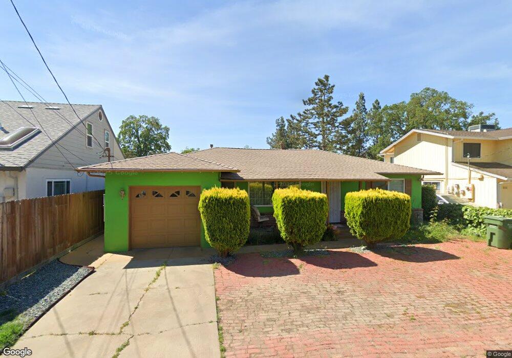
This home is located at 508 Poplar St, Galt, CA 95632 and is currently estimated at $340,848, approximately $351 per square foot. 508 Poplar St is a home located in Sacramento County with nearby schools including Vernon E. Greer Elementary School, Robert L. McCaffrey Middle School, and Galt High School.
Ownership History
Date
Name
Owned For
Owner Type
Purchase Details
Closed on
Mar 20, 2026
Sold by
Barbara Deflores and Bobbie Sunde Living Trust
Bought by
Deflores Barbara and De Flores David
Current Estimated Value
Purchase Details
Closed on
Dec 9, 2019
Sold by
Sunde Bobbie
Bought by
Sunde Bobbie
Home Financials for this Owner
Home Financials are based on the most recent Mortgage that was taken out on this home.
Original Mortgage
$420,000
Interest Rate
3.45%
Mortgage Type
Reverse Mortgage Home Equity Conversion Mortgage
Purchase Details
Closed on
May 9, 2012
Sold by
Sunde Bobbie
Bought by
Sunde Bobbie and Bobbie Sunde Living Trust
Purchase Details
Closed on
Sep 12, 2000
Sold by
Sunde Bobbie
Bought by
Sunde Bobbie and The Bobbie Sunde Living Trust
Create a Home Valuation Report for This Property
The Home Valuation Report is an in-depth analysis detailing your home's value as well as a comparison with similar homes in the area
Home Values in the Area
Average Home Value in this Area
Purchase History
| Date | Buyer | Sale Price | Title Company |
|---|---|---|---|
| Deflores Barbara | -- | None Listed On Document | |
| Sunde Bobbie | -- | Fnc Title Of California | |
| Sunde Bobbie | -- | None Available | |
| Sunde Bobbie | -- | None Available | |
| Sunde Bobbie | -- | -- |
Source: Public Records
Mortgage History
| Date | Status | Borrower | Loan Amount |
|---|---|---|---|
| Previous Owner | Sunde Bobbie | $420,000 |
Source: Public Records
Tax History
| Year | Tax Paid | Tax Assessment Tax Assessment Total Assessment is a certain percentage of the fair market value that is determined by local assessors to be the total taxable value of land and additions on the property. | Land | Improvement |
|---|---|---|---|---|
| 2025 | $518 | $54,227 | $9,207 | $45,020 |
| 2024 | $518 | $53,165 | $9,027 | $44,138 |
| 2023 | $508 | $52,123 | $8,850 | $43,273 |
| 2022 | $486 | $51,102 | $8,677 | $42,425 |
| 2021 | $485 | $50,101 | $8,507 | $41,594 |
| 2020 | $480 | $49,588 | $8,420 | $41,168 |
| 2019 | $467 | $48,616 | $8,255 | $40,361 |
| 2018 | $464 | $47,664 | $8,094 | $39,570 |
| 2017 | $445 | $46,731 | $7,936 | $38,795 |
| 2016 | $426 | $45,816 | $7,781 | $38,035 |
| 2015 | $410 | $45,129 | $7,665 | $37,464 |
| 2014 | $408 | $44,249 | $7,516 | $36,733 |
Source: Public Records
Map
Nearby Homes
- 702 Elm Ave
- 150 Spruce Ave
- 219 Lois Ave
- 104 Wildflower Dr
- 133 5th St
- 604 Pringle Ave Unit 94
- 604 Pringle Ave Unit 1
- 605 Pringle Ave Unit 26
- 605 Pringle Ave Unit 22
- 873 Delane Dr
- 240 3rd St
- 0 B St Unit 226013319
- 820 N Lincoln Way Unit 42
- 820 N Lincoln Way Unit 104
- 820 N Lincoln Way Unit 7
- 433 5th St
- 10657 Simmerhorn Rd
- 42 C St
- 194 W Elm Ave
- 319 Shelduck Ln
Your Personal Tour Guide
Ask me questions while you tour the home.