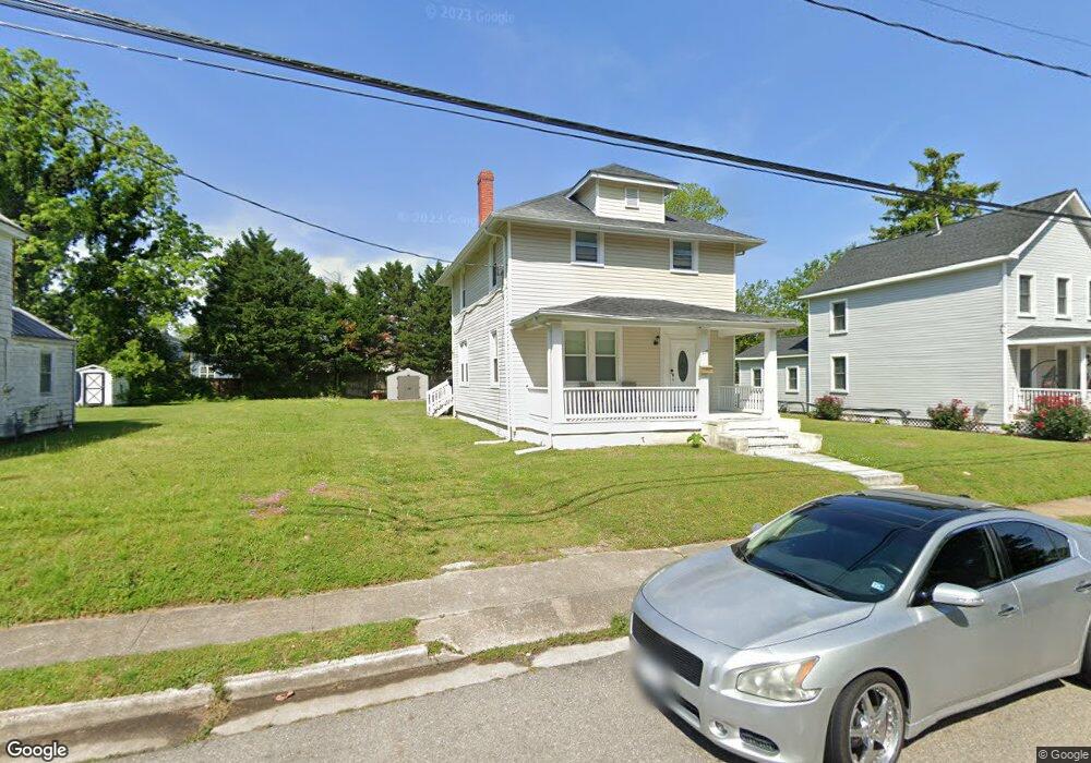
509 Eaton St Hampton, VA 23669
Pasture Point NeighborhoodEstimated Value: $289,000 - $308,000
3
Beds
3
Baths
1,625
Sq Ft
$186/Sq Ft
Est. Value
About This Home
This home is located at 509 Eaton St, Hampton, VA 23669 and is currently estimated at $302,003, approximately $185 per square foot. 509 Eaton St is a home located in Hampton City with nearby schools including Capt. John Smith Elementary School, C. Alton Lindsay Middle School, and Phoebus High School.
Ownership History
Date
Name
Owned For
Owner Type
Purchase Details
Closed on
Jan 13, 2021
Sold by
Federal City Properties Llc
Bought by
Pullum Kenneth and Pullum Troy Katika
Current Estimated Value
Home Financials for this Owner
Home Financials are based on the most recent Mortgage that was taken out on this home.
Original Mortgage
$204,250
Outstanding Balance
$182,294
Interest Rate
2.71%
Mortgage Type
New Conventional
Estimated Equity
$119,709
Purchase Details
Closed on
Jan 6, 2016
Sold by
The Estate Of Irvin L Peddrew Deceased
Bought by
Federal City Properties Llc A Maryland L
Home Financials for this Owner
Home Financials are based on the most recent Mortgage that was taken out on this home.
Original Mortgage
$119,000
Interest Rate
3.45%
Mortgage Type
New Conventional
Create a Home Valuation Report for This Property
The Home Valuation Report is an in-depth analysis detailing your home's value as well as a comparison with similar homes in the area
Home Values in the Area
Average Home Value in this Area
Purchase History
| Date | Buyer | Sale Price | Title Company |
|---|---|---|---|
| Pullum Kenneth | $215,000 | None Listed On Document | |
| Federal City Properties Llc A Maryland L | $65,000 | American Escrow & Title Co |
Source: Public Records
Mortgage History
| Date | Status | Borrower | Loan Amount |
|---|---|---|---|
| Open | Pullum Kenneth | $204,250 | |
| Previous Owner | Federal City Properties Llc A Maryland L | $119,000 |
Source: Public Records
Tax History Compared to Growth
Tax History
| Year | Tax Paid | Tax Assessment Tax Assessment Total Assessment is a certain percentage of the fair market value that is determined by local assessors to be the total taxable value of land and additions on the property. | Land | Improvement |
|---|---|---|---|---|
| 2025 | $3,601 | $304,100 | $80,000 | $224,100 |
| 2024 | $3,440 | $299,100 | $80,000 | $219,100 |
| 2023 | $3,191 | $275,100 | $80,000 | $195,100 |
| 2022 | $2,565 | $217,400 | $64,000 | $153,400 |
| 2021 | $1,558 | $115,200 | $43,200 | $72,000 |
| 2020 | $1,399 | $112,800 | $40,000 | $72,800 |
| 2019 | $1,383 | $111,500 | $40,000 | $71,500 |
| 2018 | $1,546 | $89,100 | $36,300 | $52,800 |
| 2017 | $1,199 | $0 | $0 | $0 |
| 2016 | $1,199 | $89,100 | $0 | $0 |
| 2015 | $1,399 | $0 | $0 | $0 |
| 2014 | $1,189 | $89,100 | $36,300 | $52,800 |
Source: Public Records
Map
Nearby Homes
- 418 Wine St
- 115 E Pembroke Ave
- 433 Cooper St
- 439 Cooper St
- 542 River St
- 35 Miles Cary Mews
- 840 Quash St
- 138 Eberly Terrace
- 156 Mill Point Dr
- 210 Dockside Dr Unit A
- 211 Rip Rap Rd
- 227 Dockside Dr Unit C
- 14 Myrtle St
- 10 Eberly Terrace
- 240 Dockside Dr Unit C
- 1019 Bethel Ave
- 47 Clayton Dr
- 20 Pine Cone Dr
- 1122 West Ave
- 358 Lincoln St