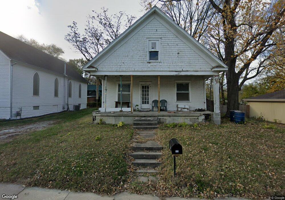
509 N 7th St Lawrence, KS 66044
North Lawrence NeighborhoodEstimated Value: $113,226 - $206,000
2
Beds
1
Bath
784
Sq Ft
$204/Sq Ft
Est. Value
About This Home
This home is located at 509 N 7th St, Lawrence, KS 66044 and is currently estimated at $160,057, approximately $204 per square foot. 509 N 7th St is a home located in Douglas County with nearby schools including Woodlawn Elementary School, Liberty Memorial Central Middle School, and Lawrence Free State High School.
Ownership History
Date
Name
Owned For
Owner Type
Purchase Details
Closed on
Dec 30, 2013
Sold by
Midwest Annual Conference Board Of Trust
Bought by
Artfarm Llc
Current Estimated Value
Home Financials for this Owner
Home Financials are based on the most recent Mortgage that was taken out on this home.
Original Mortgage
$56,000
Outstanding Balance
$42,228
Interest Rate
4.36%
Mortgage Type
Future Advance Clause Open End Mortgage
Estimated Equity
$117,829
Create a Home Valuation Report for This Property
The Home Valuation Report is an in-depth analysis detailing your home's value as well as a comparison with similar homes in the area
Home Values in the Area
Average Home Value in this Area
Purchase History
| Date | Buyer | Sale Price | Title Company |
|---|---|---|---|
| Artfarm Llc | -- | Kansas Secured Title |
Source: Public Records
Mortgage History
| Date | Status | Borrower | Loan Amount |
|---|---|---|---|
| Open | Artfarm Llc | $56,000 |
Source: Public Records
Tax History Compared to Growth
Tax History
| Year | Tax Paid | Tax Assessment Tax Assessment Total Assessment is a certain percentage of the fair market value that is determined by local assessors to be the total taxable value of land and additions on the property. | Land | Improvement |
|---|---|---|---|---|
| 2025 | $749 | $6,879 | $5,175 | $1,704 |
| 2024 | $688 | $6,304 | $4,600 | $1,704 |
| 2023 | $666 | $5,783 | $4,025 | $1,758 |
| 2022 | $685 | $5,845 | $3,450 | $2,395 |
| 2021 | $745 | $5,818 | $2,760 | $3,058 |
| 2020 | $676 | $5,337 | $2,760 | $2,577 |
| 2019 | $682 | $5,390 | $2,760 | $2,630 |
| 2018 | $973 | $7,489 | $2,760 | $4,729 |
| 2017 | $648 | $5,044 | $2,744 | $2,300 |
| 2016 | $619 | $5,044 | $2,744 | $2,300 |
| 2015 | -- | $10,074 | $2,744 | $7,330 |
| 2014 | -- | $10,344 | $2,744 | $7,600 |
Source: Public Records
Map
Nearby Homes
- 809 Maple St
- 516 Lake St
- 705 Rhode Island St Unit F
- 705 Rhode Island St Unit B
- 705 Rhode Island St Unit A
- 705 Rhode Island St Unit P
- 705 Rhode Island St Unit Q
- 705 Rhode Island St Unit J
- 705 Rhode Island St Unit E
- 705 Rhode Island St Unit K
- 705 Rhode Island St Unit D
- 705 Rhode Island St Unit C
- 705 Rhode Island St Unit N
- 705 Rhode Island St Unit H
- 705 Rhode Island St Unit L
- 705 Rhode Island St Unit G
- 705 Rhode Island St Unit M
- 918 Pennsylvania St
- 800 New Hampshire St Unit 204
- 619 W 4th St
- 633 Maple St
- 701 Maple St
- 525 N 7th St
- 623 Maple St
- 516 N 7th St
- 516 N 7th St
- 522 N 7th St
- 711 Maple St
- 527 N 7th St
- 529 N 7th St
- 713 Locust St
- 645 Locust St
- 722 Grant St
- 719 Locust St
- 601 Maple St
- 731 Grant St
- 731 Grant St Unit 755-757 Grant St
- 731 Grant St Unit 733 Grant St
- 733 Grant St
- 624 Lincoln St