Estimated Value: $398,000 - $576,000
3
Beds
2
Baths
1,576
Sq Ft
$296/Sq Ft
Est. Value
About This Home
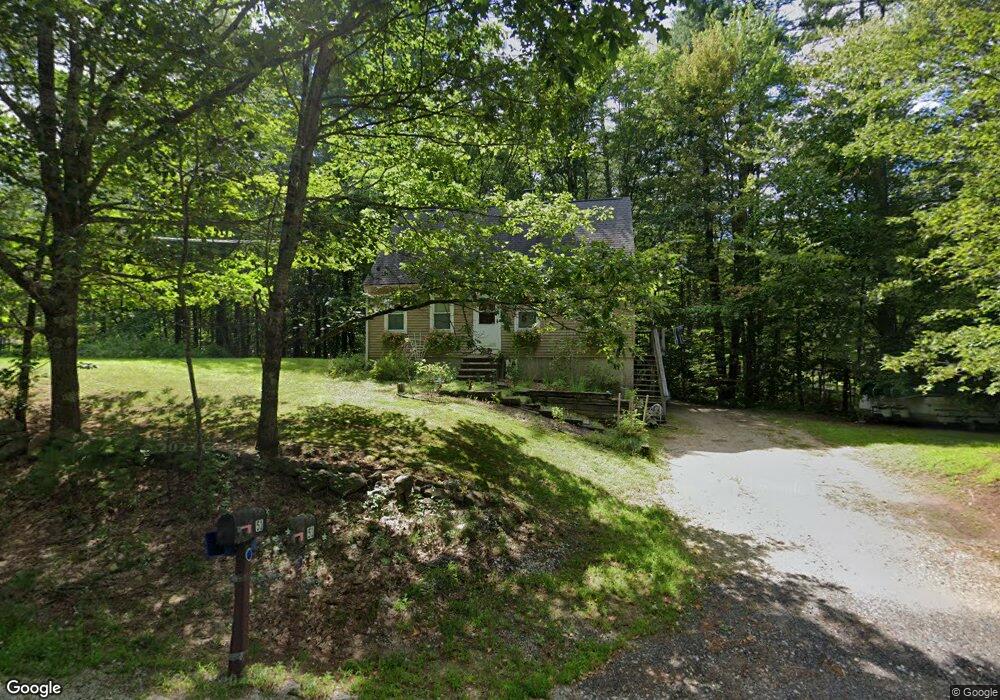
This home is located at 51 N Pembroke Rd, Epsom, NH 03234 and is currently estimated at $467,242, approximately $296 per square foot. 51 N Pembroke Rd is a home located in Merrimack County with nearby schools including Epsom Central School and Tender Years Child Care & Learning Center.
Ownership History
Date
Name
Owned For
Owner Type
Purchase Details
Closed on
Jun 19, 2001
Sold by
Carroll Craig E
Bought by
Cormier Sonia M and Cormier Wayne M
Current Estimated Value
Home Financials for this Owner
Home Financials are based on the most recent Mortgage that was taken out on this home.
Original Mortgage
$139,867
Outstanding Balance
$53,317
Interest Rate
7.15%
Estimated Equity
$413,925
Purchase Details
Closed on
Oct 24, 1997
Sold by
Duval Richard J
Bought by
Carroll Craig E
Home Financials for this Owner
Home Financials are based on the most recent Mortgage that was taken out on this home.
Original Mortgage
$106,590
Interest Rate
7.48%
Create a Home Valuation Report for This Property
The Home Valuation Report is an in-depth analysis detailing your home's value as well as a comparison with similar homes in the area
Home Values in the Area
Average Home Value in this Area
Purchase History
| Date | Buyer | Sale Price | Title Company |
|---|---|---|---|
| Cormier Sonia M | $141,000 | -- | |
| Carroll Craig E | $104,500 | -- |
Source: Public Records
Mortgage History
| Date | Status | Borrower | Loan Amount |
|---|---|---|---|
| Open | Carroll Craig E | $139,867 | |
| Previous Owner | Carroll Craig E | $106,590 |
Source: Public Records
Tax History Compared to Growth
Tax History
| Year | Tax Paid | Tax Assessment Tax Assessment Total Assessment is a certain percentage of the fair market value that is determined by local assessors to be the total taxable value of land and additions on the property. | Land | Improvement |
|---|---|---|---|---|
| 2024 | $5,850 | $219,600 | $95,400 | $124,200 |
| 2023 | $5,409 | $219,600 | $95,400 | $124,200 |
| 2022 | $5,235 | $219,600 | $95,400 | $124,200 |
| 2021 | $5,191 | $219,600 | $95,400 | $124,200 |
| 2020 | $4,794 | $219,600 | $95,400 | $124,200 |
| 2019 | $4,947 | $182,600 | $79,500 | $103,100 |
| 2018 | $4,742 | $182,600 | $79,500 | $103,100 |
| 2017 | $4,687 | $182,600 | $79,500 | $103,100 |
| 2016 | $4,570 | $182,600 | $79,500 | $103,100 |
| 2015 | $4,350 | $182,600 | $79,500 | $103,100 |
| 2014 | $3,900 | $175,200 | $67,800 | $107,400 |
| 2013 | $3,929 | $174,100 | $67,800 | $106,300 |
Source: Public Records
Map
Nearby Homes
- 0 Poor Town Rd Unit 4
- 370 River Rd
- 9 Princess Ln
- 11 Presidential Dr
- 43 Catamount Hill Dr
- 8 Bush Ave
- 1 Jefferson Ave
- 5 Catamount Hill Dr
- 41 Monroe Ave
- 101 4th Range Rd Unit 4
- 425 Grady Ln Unit 28
- 441 Blane Cir Unit 12
- 452 Blane Cir Unit 45
- 9 Pine Acres Rd
- 401 Sixth Range Rd
- 348 Brickett Hill Rd Unit 3
- 344 Brickett Hill Rd Unit 2
- 344 Brickett Hill Rd
- 340 Brickett Hill Rd
- 611 N Pembroke Rd
- 43 N Pembroke Rd
- 33 N Pembroke Rd
- 59 N Pembroke Rd
- 23 N Pembroke Rd
- 29 N Pembroke Rd
- 65 N Pembroke Rd
- 46 N Pembroke Rd
- 54 N Pembroke Rd
- 79 N Pembroke Rd
- 38 N Pembroke Rd
- 9 N Pembroke Rd
- 30 N Pembroke Rd
- 85 N Pembroke Rd
- 28 N Pembroke Rd
- 55 N Pembroke Rd
- 78 N Pembroke Rd
- 62 N Pembroke Rd
- 16 N Pembroke Rd
- 93 N Pembroke Rd
- 136 N Pembroke Rd