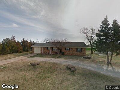
510 N Locust St Temple, OK 73568
Estimated Value: $48,000 - $100,330
3
Beds
2
Baths
1,400
Sq Ft
$57/Sq Ft
Est. Value
About This Home
This home is located at 510 N Locust St, Temple, OK 73568 and is currently estimated at $79,333, approximately $56 per square foot. 510 N Locust St is a home located in Cotton County with nearby schools including Temple Elementary School and Temple High School.
Ownership History
Date
Name
Owned For
Owner Type
Purchase Details
Closed on
Jun 30, 2011
Sold by
Carroll Steven and Carroll Christina
Bought by
Brown Michael D
Current Estimated Value
Home Financials for this Owner
Home Financials are based on the most recent Mortgage that was taken out on this home.
Original Mortgage
$46,632
Outstanding Balance
$32,828
Interest Rate
4.55%
Mortgage Type
New Conventional
Estimated Equity
$46,505
Purchase Details
Closed on
Aug 29, 2001
Sold by
Bonita Coston Harrel
Bought by
Steven Carroll
Create a Home Valuation Report for This Property
The Home Valuation Report is an in-depth analysis detailing your home's value as well as a comparison with similar homes in the area
Home Values in the Area
Average Home Value in this Area
Purchase History
| Date | Buyer | Sale Price | Title Company |
|---|---|---|---|
| Brown Michael D | $45,000 | Stewart Abstract & Title Of | |
| Steven Carroll | $36,000 | -- |
Source: Public Records
Mortgage History
| Date | Status | Borrower | Loan Amount |
|---|---|---|---|
| Open | Brown Michael D | $46,632 | |
| Previous Owner | Carroll Steven | $40,115 |
Source: Public Records
Tax History Compared to Growth
Tax History
| Year | Tax Paid | Tax Assessment Tax Assessment Total Assessment is a certain percentage of the fair market value that is determined by local assessors to be the total taxable value of land and additions on the property. | Land | Improvement |
|---|---|---|---|---|
| 2024 | $473 | $6,251 | $86 | $6,165 |
| 2023 | $547 | $6,069 | $86 | $5,983 |
| 2022 | $534 | $6,069 | $86 | $5,983 |
| 2021 | $534 | $6,069 | $86 | $5,983 |
| 2020 | $559 | $6,282 | $86 | $6,196 |
| 2019 | $556 | $6,167 | $86 | $6,081 |
| 2018 | $516 | $5,873 | $86 | $5,787 |
| 2017 | $517 | $5,873 | $86 | $5,787 |
| 2016 | $499 | $5,594 | $86 | $5,508 |
| 2015 | $303 | $4,067 | $86 | $3,981 |
| 2014 | $400 | $4,719 | $86 | $4,633 |
Source: Public Records
Map
Nearby Homes
- 516 E Minnesota St
- 407 N Cherry Ave
- 900 SE Boundary St
- 000 N 2700 and E 1880 Rd
- 000 N 2710 Rd
- 000 Highway 53 and N 2680 Rd
- 509 E South Boundary St
- 514 E Washington Ave
- 506 E Nevada St
- 185318 185318 Falcon Rd
- 309 E Washington St
- 506 E Oklahoma St
- 412 E Oklahoma St
- 220 E Kansas St
- 411 E Iowa Ave
- 321 N 3rd St
- 0 Oak Dr Unit 2516340
- 119 W Iowa St
- 110 4th St
- 186233 N 2740 Rd