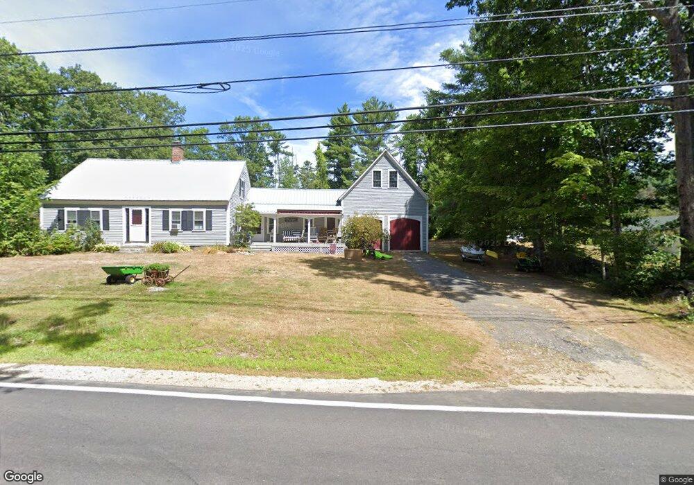
511 Governor Wentworth Hwy Wolfeboro, NH 03894
Estimated Value: $520,804 - $999,000
4
Beds
2
Baths
2,206
Sq Ft
$355/Sq Ft
Est. Value
About This Home
This home is located at 511 Governor Wentworth Hwy, Wolfeboro, NH 03894 and is currently estimated at $782,951, approximately $354 per square foot. 511 Governor Wentworth Hwy is a home with nearby schools including Tuftonboro Central School, Kingswood Regional Middle School, and Kingswood Regional High School.
Ownership History
Date
Name
Owned For
Owner Type
Purchase Details
Closed on
Jun 25, 2024
Sold by
Buchanan Douglas L
Bought by
Buchanan Lesley C and Buchanan Douglas L
Current Estimated Value
Create a Home Valuation Report for This Property
The Home Valuation Report is an in-depth analysis detailing your home's value as well as a comparison with similar homes in the area
Home Values in the Area
Average Home Value in this Area
Purchase History
| Date | Buyer | Sale Price | Title Company |
|---|---|---|---|
| Buchanan Lesley C | -- | None Available | |
| Buchanan Lesley C | -- | None Available | |
| Buchanan Douglas L | -- | None Available |
Source: Public Records
Tax History Compared to Growth
Tax History
| Year | Tax Paid | Tax Assessment Tax Assessment Total Assessment is a certain percentage of the fair market value that is determined by local assessors to be the total taxable value of land and additions on the property. | Land | Improvement |
|---|---|---|---|---|
| 2024 | $3,525 | $462,600 | $169,300 | $293,300 |
| 2023 | $3,363 | $462,600 | $169,300 | $293,300 |
| 2022 | $2,979 | $462,600 | $169,300 | $293,300 |
| 2021 | $2,661 | $264,000 | $76,500 | $187,500 |
| 2020 | $2,524 | $264,000 | $76,500 | $187,500 |
| 2019 | $2,669 | $264,000 | $76,500 | $187,500 |
| 2018 | $2,158 | $197,100 | $87,000 | $110,100 |
| 2017 | $2,123 | $197,100 | $87,000 | $110,100 |
| 2016 | $2,056 | $197,100 | $87,000 | $110,100 |
| 2015 | $2,048 | $197,100 | $87,000 | $110,100 |
| 2014 | $1,957 | $195,900 | $87,000 | $108,900 |
| 2012 | $2,120 | $231,900 | $104,500 | $127,400 |
Source: Public Records
Map
Nearby Homes
- 7 Flint Dr
- 4 Mill Pond Rd
- 4 Partridge Berry Cir
- 3 Mountain Shadows Dr Unit 2
- 14 Island View Dr
- 9 Lady Slipper Ln
- 323 Governor Wentworth Hwy
- 7 Lady Slipper Ln
- 24 Shirley Way
- 00 Beede Rd
- 16 Long Island Rd
- 27 First Point Rd
- Lot 4 Vere Royce Rd
- Lot 25 Ridge Field Rd
- 10 Woodridge Rd
- 167 Long Island Rd
- 61 Dame Rd
- 2 Oak Leaf Ave
- 31 Rays Way
- 122-001-002 Governor Wentworth Hwy
- 11 Harvest Ln
- 4 Harvest Ln
- 512 Governor Wentworth Hwy
- 510 Governor Wentworth Hwy
- 8 Lanes End Rd
- 10 Harvest Ln
- 4 Harvest Ln
- 15 Harvest Ln
- 10 Lanes End Rd
- 6 Harvest Ln
- 4 Lanes End Rd
- 9 Harvest Ln
- 12 Lanes End Rd Unit 12
- 5 Melvin Wharf Rd
- 0 Gov Wentworth Hwy Unit 4056941
- 13 Lanes End Rd
- 7 Flint Dr
- 13 Lanes End Rd
- 0 Harvest Ln Unit 25
- Lot 2 Harvest Ln