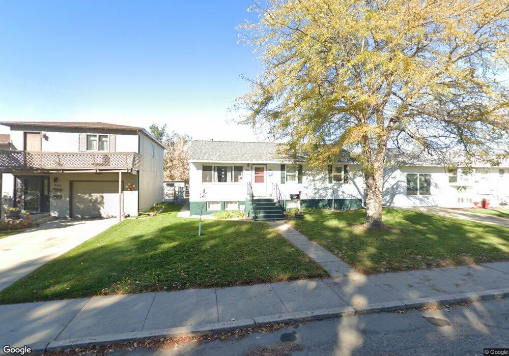
511 N Taylor Ave Glendive, MT 59330
Estimated Value: $120,000 - $248,805
5
Beds
2
Baths
960
Sq Ft
$198/Sq Ft
Est. Value
About This Home
This home is located at 511 N Taylor Ave, Glendive, MT 59330 and is currently estimated at $189,951, approximately $197 per square foot. 511 N Taylor Ave is a home located in Dawson County with nearby schools including Jefferson Elementary School, Lincoln School, and Washington Middle School.
Ownership History
Date
Name
Owned For
Owner Type
Purchase Details
Closed on
Jul 7, 2023
Sold by
Smith Lloyd C and Smith Ruthie L
Bought by
Westenrider Sean
Current Estimated Value
Home Financials for this Owner
Home Financials are based on the most recent Mortgage that was taken out on this home.
Original Mortgage
$179,550
Outstanding Balance
$175,283
Interest Rate
6.81%
Mortgage Type
Construction
Estimated Equity
$14,668
Purchase Details
Closed on
Jul 29, 2019
Sold by
Dolch John G and Dolch Virginia L
Bought by
Smith Lloyd C
Home Financials for this Owner
Home Financials are based on the most recent Mortgage that was taken out on this home.
Original Mortgage
$132,554
Interest Rate
3.37%
Mortgage Type
FHA
Purchase Details
Closed on
Jun 27, 2006
Bought by
Dolch John G and Dolch Virginia
Create a Home Valuation Report for This Property
The Home Valuation Report is an in-depth analysis detailing your home's value as well as a comparison with similar homes in the area
Home Values in the Area
Average Home Value in this Area
Purchase History
| Date | Buyer | Sale Price | Title Company |
|---|---|---|---|
| Westenrider Sean | $224,437 | Flying S Title & Escrow | |
| Smith Lloyd C | $133,879 | First American Title | |
| Dolch John G | -- | -- |
Source: Public Records
Mortgage History
| Date | Status | Borrower | Loan Amount |
|---|---|---|---|
| Open | Westenrider Sean | $179,550 | |
| Previous Owner | Smith Lloyd C | $132,554 |
Source: Public Records
Tax History
| Year | Tax Paid | Tax Assessment Tax Assessment Total Assessment is a certain percentage of the fair market value that is determined by local assessors to be the total taxable value of land and additions on the property. | Land | Improvement |
|---|---|---|---|---|
| 2025 | $1,987 | $195,600 | $0 | $0 |
| 2024 | $2,610 | $163,300 | $0 | $0 |
| 2023 | $2,455 | $163,300 | $0 | $0 |
| 2022 | $2,084 | $133,500 | $0 | $0 |
| 2021 | $1,459 | $133,500 | $0 | $0 |
| 2020 | $1,773 | $121,100 | $0 | $0 |
| 2019 | $1,772 | $121,100 | $0 | $0 |
| 2018 | $2,145 | $163,200 | $0 | $0 |
| 2017 | $1,850 | $170,300 | $0 | $0 |
| 2016 | $1,859 | $135,400 | $0 | $0 |
| 2015 | $1,669 | $135,400 | $0 | $0 |
| 2014 | $1,161 | $52,894 | $0 | $0 |
Source: Public Records
Map
Nearby Homes
- 515 N Taylor Ave
- 505 N Taylor Ave
- 515 E Borden St
- 521 E Borden St
- 517 N Taylor Ave
- 512 E Dodge St
- 510 N Nowlan Ave
- 514 N Nowlan Ave
- 506 N Nowlan Ave
- 512 N Taylor Ave
- 518 N Nowlan Ave
- 500 N Nowlan Ave
- 504 N Taylor Ave
- 603 E Borden St
- 522 N Nowlan Ave
- 500 E Borden St
- 508 N Taylor Ave
- 502 E Borden St
- 516 N Taylor Ave
- 602 E Dodge St
Your Personal Tour Guide
Ask me questions while you tour the home.