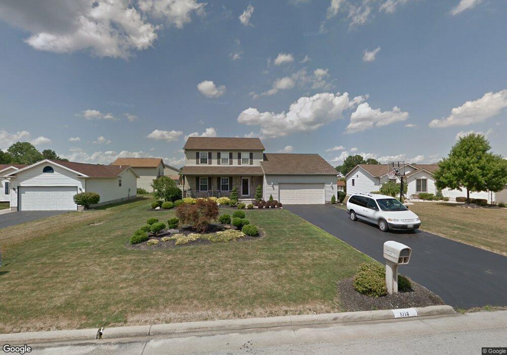
5116 Raspberry Ln Mineral Ridge, OH 44440
Austintown NeighborhoodEstimated Value: $219,000 - $309,000
3
Beds
3
Baths
1,848
Sq Ft
$150/Sq Ft
Est. Value
About This Home
This home is located at 5116 Raspberry Ln, Mineral Ridge, OH 44440 and is currently estimated at $276,496, approximately $149 per square foot. 5116 Raspberry Ln is a home located in Mahoning County with nearby schools including Austintown Elementary School, Austintown Intermediate School, and Austintown Middle School.
Ownership History
Date
Name
Owned For
Owner Type
Purchase Details
Closed on
Oct 17, 1997
Sold by
Latessa Construction
Bought by
Vergallito Steven D and Vergallito Jennie Lynn
Current Estimated Value
Home Financials for this Owner
Home Financials are based on the most recent Mortgage that was taken out on this home.
Original Mortgage
$105,381
Outstanding Balance
$17,228
Interest Rate
7.65%
Mortgage Type
Purchase Money Mortgage
Estimated Equity
$259,268
Create a Home Valuation Report for This Property
The Home Valuation Report is an in-depth analysis detailing your home's value as well as a comparison with similar homes in the area
Home Values in the Area
Average Home Value in this Area
Purchase History
| Date | Buyer | Sale Price | Title Company |
|---|---|---|---|
| Vergallito Steven D | $117,000 | -- |
Source: Public Records
Mortgage History
| Date | Status | Borrower | Loan Amount |
|---|---|---|---|
| Open | Vergallito Steven D | $105,381 |
Source: Public Records
Tax History Compared to Growth
Tax History
| Year | Tax Paid | Tax Assessment Tax Assessment Total Assessment is a certain percentage of the fair market value that is determined by local assessors to be the total taxable value of land and additions on the property. | Land | Improvement |
|---|---|---|---|---|
| 2024 | $4,179 | $90,630 | $6,650 | $83,980 |
| 2023 | $4,105 | $90,630 | $6,650 | $83,980 |
| 2022 | $3,674 | $65,030 | $6,650 | $58,380 |
| 2021 | $3,678 | $65,030 | $6,650 | $58,380 |
| 2020 | $3,692 | $65,030 | $6,650 | $58,380 |
| 2019 | $3,621 | $57,860 | $6,650 | $51,210 |
| 2018 | $3,486 | $57,860 | $6,650 | $51,210 |
| 2017 | $3,472 | $57,860 | $6,650 | $51,210 |
| 2016 | $3,478 | $57,440 | $6,650 | $50,790 |
| 2015 | $3,372 | $57,440 | $6,650 | $50,790 |
| 2014 | $3,386 | $57,440 | $6,650 | $50,790 |
| 2013 | $3,349 | $57,440 | $6,650 | $50,790 |
Source: Public Records
Map
Nearby Homes
- 5085 Winslow Dr
- 1239 Woodledge Dr
- 1684 Morris St
- 0 W Webb Rd
- 1467 E County Line Rd
- 1445 E County Line Rd
- 21 E Liberty St
- 3872 Main St
- 645 Carlin Dr
- 3907 Edwards St
- 3579 Bee St
- 2169 Salt Springs Rd
- 0 W Liberty Unit 5153649
- 3474 S Main St
- 6360 Meander Glen Dr
- 4028 Lanterman Rd
- 2555 Walnut St
- 4020 Lanterman Rd
- 6393 Meander Glen Dr
- 3440 Lakeside Dr
- 5112 Raspberry Ln
- 5120 Raspberry Ln
- 1323 Raspberry Ln
- 5108 Raspberry Ln
- 1331 Raspberry Ln
- 1316 Mulberry Run
- 5111 Raspberry Ln
- 5119 Raspberry Ln
- 5104 Raspberry Ln
- 5107 Raspberry Ln
- 1324 Mulberry Run
- 1339 Raspberry Ln
- 1286 Raspberry Ln
- 1310 Raspberry Ln
- 1318 Raspberry Ln
- 1302 Raspberry Ln
- 5103 Raspberry Ln
- 1332 Mulberry Run
- 5116 Clearfield Dr
- 1326 Raspberry Ln