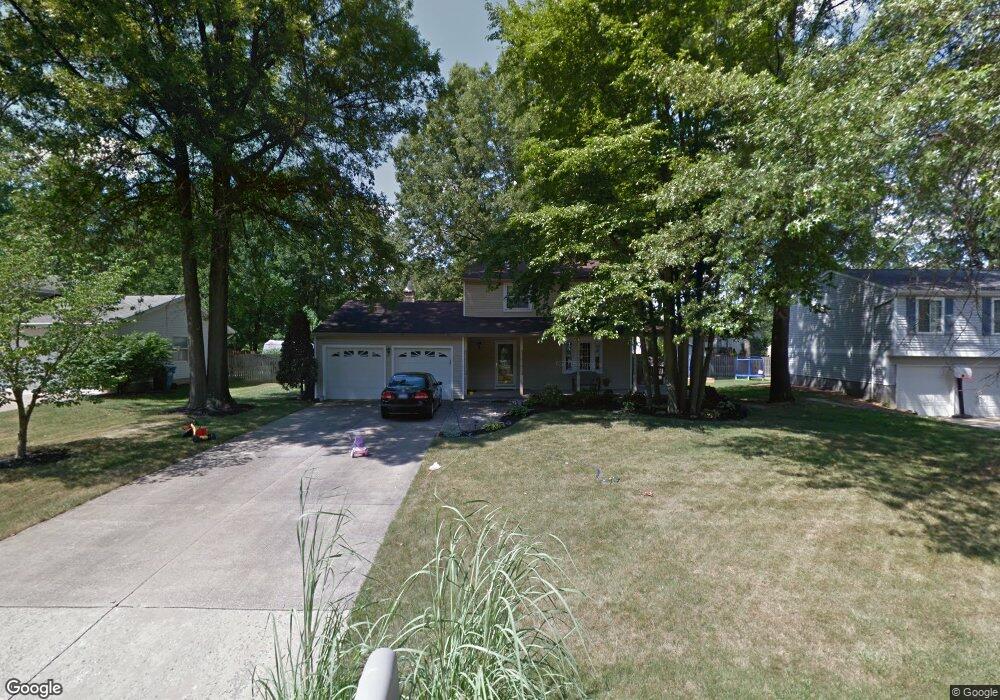
5126 Winslow Dr Mineral Ridge, OH 44440
Austintown NeighborhoodEstimated Value: $208,000 - $246,000
3
Beds
2
Baths
1,400
Sq Ft
$159/Sq Ft
Est. Value
About This Home
This home is located at 5126 Winslow Dr, Mineral Ridge, OH 44440 and is currently estimated at $222,159, approximately $158 per square foot. 5126 Winslow Dr is a home located in Mahoning County with nearby schools including Seaborn Elementary School, Mineral Ridge High School, and Summit Academy - Youngstown.
Ownership History
Date
Name
Owned For
Owner Type
Purchase Details
Closed on
Jan 31, 2004
Sold by
Glunt Patrick J and Glunt Diana L
Bought by
Caraway Christopher C and Shelar Kelli R
Current Estimated Value
Home Financials for this Owner
Home Financials are based on the most recent Mortgage that was taken out on this home.
Original Mortgage
$89,200
Outstanding Balance
$42,067
Interest Rate
5.91%
Mortgage Type
Purchase Money Mortgage
Estimated Equity
$180,092
Purchase Details
Closed on
Mar 29, 1994
Bought by
Glunt Patrick J and Glunt Diana
Create a Home Valuation Report for This Property
The Home Valuation Report is an in-depth analysis detailing your home's value as well as a comparison with similar homes in the area
Home Values in the Area
Average Home Value in this Area
Purchase History
| Date | Buyer | Sale Price | Title Company |
|---|---|---|---|
| Caraway Christopher C | $111,500 | -- | |
| Glunt Patrick J | $87,000 | -- |
Source: Public Records
Mortgage History
| Date | Status | Borrower | Loan Amount |
|---|---|---|---|
| Open | Caraway Christopher C | $89,200 | |
| Closed | Caraway Christopher C | $22,300 |
Source: Public Records
Tax History Compared to Growth
Tax History
| Year | Tax Paid | Tax Assessment Tax Assessment Total Assessment is a certain percentage of the fair market value that is determined by local assessors to be the total taxable value of land and additions on the property. | Land | Improvement |
|---|---|---|---|---|
| 2024 | $2,860 | $55,430 | $6,650 | $48,780 |
| 2023 | $2,833 | $55,430 | $6,650 | $48,780 |
| 2022 | $2,358 | $40,720 | $6,650 | $34,070 |
| 2021 | $2,359 | $40,720 | $6,650 | $34,070 |
| 2020 | $2,367 | $40,720 | $6,650 | $34,070 |
| 2019 | $2,336 | $36,530 | $6,650 | $29,880 |
| 2018 | $2,253 | $36,530 | $6,650 | $29,880 |
| 2017 | $2,232 | $36,530 | $6,650 | $29,880 |
| 2016 | $2,149 | $33,840 | $6,650 | $27,190 |
| 2015 | $2,088 | $33,840 | $6,650 | $27,190 |
| 2014 | $2,276 | $33,840 | $6,650 | $27,190 |
| 2013 | $2,084 | $33,840 | $6,650 | $27,190 |
Source: Public Records
Map
Nearby Homes
- 5085 Winslow Dr
- 1239 Woodledge Dr
- 0 W Webb Rd
- 1467 E County Line Rd
- 21 E Liberty St
- 1445 E County Line Rd
- 1684 Morris St
- 3872 Main St
- 3907 Edwards St
- 645 Carlin Dr
- 3579 Bee St
- 6360 Meander Glen Dr
- 6393 Meander Glen Dr
- 3474 S Main St
- 5231 W Rockwell Rd
- 0 W Liberty Unit 5153649
- 3440 Lakeside Dr
- 176 N Canfield Niles Rd
- 159 N Canfield Niles Rd
- 4028 Lanterman Rd
- 5122 Winslow Dr
- 5130 Winslow Dr
- 5143 Clearfield Dr
- 5147 Clearfield Dr
- 5118 Winslow Dr
- 5134 Winslow Dr
- 5139 Clearfield Dr
- 5125 Winslow Dr
- 5128 Winslow Dr
- 5121 Winslow Dr
- 5135 Clearfield Dr
- 5133 Winslow Dr
- 5114 Winslow Dr
- 5117 Winslow Dr
- 5131 Clearfield Dr
- 5137 Winslow Dr
- 5113 Winslow Dr
- 5102 Pine Shadow Ct
- 5110 Winslow Dr
- 5142 Winslow Dr