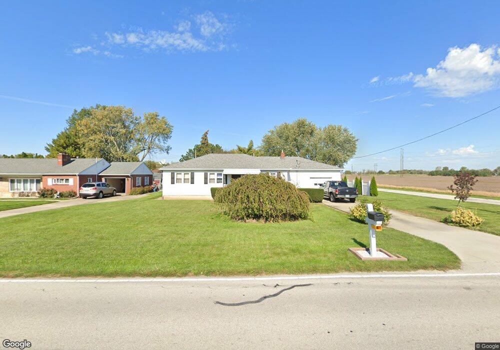
513 E Union St Walbridge, OH 43465
Estimated Value: $200,000 - $210,000
4
Beds
2
Baths
1,320
Sq Ft
$155/Sq Ft
Est. Value
About This Home
This home is located at 513 E Union St, Walbridge, OH 43465 and is currently estimated at $204,912, approximately $155 per square foot. 513 E Union St is a home located in Wood County with nearby schools including Lake Elementary School, Lake Middle School, and Lake High School.
Ownership History
Date
Name
Owned For
Owner Type
Purchase Details
Closed on
Jul 25, 2008
Sold by
Hazel Thomas E and Hazel Beverly E
Bought by
Hazel Thomas T
Current Estimated Value
Home Financials for this Owner
Home Financials are based on the most recent Mortgage that was taken out on this home.
Original Mortgage
$80,000
Interest Rate
6.5%
Mortgage Type
Purchase Money Mortgage
Purchase Details
Closed on
Jan 1, 1990
Bought by
Hazel Thomas E
Create a Home Valuation Report for This Property
The Home Valuation Report is an in-depth analysis detailing your home's value as well as a comparison with similar homes in the area
Home Values in the Area
Average Home Value in this Area
Purchase History
| Date | Buyer | Sale Price | Title Company |
|---|---|---|---|
| Hazel Thomas T | $100,000 | Chicago Title Insurance Co | |
| Hazel Thomas E | -- | -- |
Source: Public Records
Mortgage History
| Date | Status | Borrower | Loan Amount |
|---|---|---|---|
| Closed | Hazel Thomas T | $80,000 |
Source: Public Records
Tax History
| Year | Tax Paid | Tax Assessment Tax Assessment Total Assessment is a certain percentage of the fair market value that is determined by local assessors to be the total taxable value of land and additions on the property. | Land | Improvement |
|---|---|---|---|---|
| 2025 | $2,334 | $52,500 | $14,910 | $37,590 |
| 2024 | $2,271 | $52,500 | $14,910 | $37,590 |
| 2023 | $2,324 | $52,500 | $14,910 | $37,590 |
| 2021 | $2,242 | $43,160 | $14,770 | $28,390 |
| 2020 | $2,154 | $43,160 | $14,770 | $28,390 |
| 2019 | $2,037 | $37,630 | $14,770 | $22,860 |
| 2018 | $2,035 | $37,630 | $14,770 | $22,860 |
| 2017 | $2,049 | $37,630 | $14,770 | $22,860 |
| 2016 | $2,026 | $38,540 | $14,770 | $23,770 |
| 2015 | $2,026 | $38,220 | $14,770 | $23,450 |
| 2014 | $2,124 | $38,220 | $14,770 | $23,450 |
| 2013 | $1,904 | $32,830 | $14,770 | $18,060 |
Source: Public Records
Map
Nearby Homes
- 225 E Union St
- 30236 Lemoyne Rd
- 114 E Perry St
- 236 S Bridge Rd
- 238 S Bridge Rd
- 232 S Bridge Rd
- 241 S Bridge Rd
- 237 S Bridge Rd
- 100 W Union St
- 30643 Drouillard Rd
- 3901 Plumey Rd
- 0 Williston Rd
- 199 E Bridge Rd
- 115 W Bridge Rd
- 113 W Bridge Rd
- 111 W Bridge Rd
- 117 W Bridge Rd
- 230 S Bridge Rd
- 209 E Bridge Rd
- 3517 Goodrich Ave
Your Personal Tour Guide
Ask me questions while you tour the home.