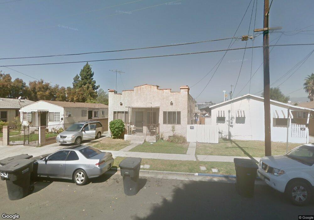
5131 Astor Ave Commerce, CA 90040
Estimated Value: $647,000 - $798,000
2
Beds
2
Baths
1,064
Sq Ft
$659/Sq Ft
Est. Value
About This Home
This home is located at 5131 Astor Ave, Commerce, CA 90040 and is currently estimated at $700,940, approximately $658 per square foot. 5131 Astor Ave is a home located in Los Angeles County with nearby schools including Bandini Elementary School, Rosewood Park School, and Bell Gardens High.
Ownership History
Date
Name
Owned For
Owner Type
Purchase Details
Closed on
Jan 22, 2026
Sold by
Quiroz Enriquetta
Bought by
Enriquetta Quiroz Living Trust and Quiroz
Current Estimated Value
Purchase Details
Closed on
Aug 1, 2002
Sold by
Branson Robert F and Branson Connie
Bought by
Quiroz Enriquetta
Purchase Details
Closed on
Sep 29, 1993
Sold by
Branson Connie and Quiroz Enriquetta
Bought by
Branson Robert F
Home Financials for this Owner
Home Financials are based on the most recent Mortgage that was taken out on this home.
Original Mortgage
$113,000
Interest Rate
6.95%
Create a Home Valuation Report for This Property
The Home Valuation Report is an in-depth analysis detailing your home's value as well as a comparison with similar homes in the area
Home Values in the Area
Average Home Value in this Area
Purchase History
| Date | Buyer | Sale Price | Title Company |
|---|---|---|---|
| Enriquetta Quiroz Living Trust | -- | None Listed On Document | |
| Quiroz Enriquetta | $35,000 | -- | |
| Branson Robert F | -- | Stewart Title |
Source: Public Records
Mortgage History
| Date | Status | Borrower | Loan Amount |
|---|---|---|---|
| Previous Owner | Branson Robert F | $113,000 |
Source: Public Records
Tax History
| Year | Tax Paid | Tax Assessment Tax Assessment Total Assessment is a certain percentage of the fair market value that is determined by local assessors to be the total taxable value of land and additions on the property. | Land | Improvement |
|---|---|---|---|---|
| 2025 | $4,235 | $323,869 | $177,065 | $146,804 |
| 2024 | $4,235 | $317,520 | $173,594 | $143,926 |
| 2023 | $4,241 | $311,295 | $170,191 | $141,104 |
| 2022 | $4,096 | $305,192 | $166,854 | $138,338 |
| 2021 | $3,959 | $299,209 | $163,583 | $135,626 |
| 2019 | $3,810 | $290,336 | $158,732 | $131,604 |
| 2018 | $3,822 | $284,644 | $155,620 | $129,024 |
| 2016 | $3,655 | $273,593 | $149,578 | $124,015 |
| 2015 | $3,438 | $269,485 | $147,332 | $122,153 |
| 2014 | $3,401 | $264,207 | $144,446 | $119,761 |
Source: Public Records
Map
Nearby Homes
- 2206 Cowlin Ave
- 1438 S Woods Ave
- 1335 S Woods Ave
- 1347 Fraser Ave Unit 1-3
- 5573 Pueblo Ct
- 4908 Jillson St
- 1234 Clela Ave
- 1227 S Atlantic Blvd
- 2520 Valentina Way Unit 6
- 2560 Valentina Way Unit 2
- 4633 Leonis St
- 4610 Leonis St
- 1114 S Kern Ave
- 1123 S Kern Ave
- 946 S Vancouver Ave
- 5700 Jillson St
- 5714 Jillson St
- 946 S Ferris Ave
- 5110 Whittier Blvd
- 1123 S Mcdonnell Ave
- 5127 Astor Ave
- 5135 Astor Ave
- 5139 Astor Ave
- 5121 Astor Ave
- 5143 Astor Ave
- 5147 Astor Ave
- 5120 Astor Ave
- 5137 E Farrar St
- 2113 Cowlin Ave
- 5153 Astor Ave
- 2109 Cowlin Ave
- 5114 Astor Ave
- 2103 Cowlin Ave
- 2127 Cowlin Ave
- 5155 Astor Ave
- 5110 Astor Ave
- 2137 Cowlin Ave
- 5159 Astor Ave
- 5115 Everington St
- 5103 Astor Ave
Your Personal Tour Guide
Ask me questions while you tour the home.