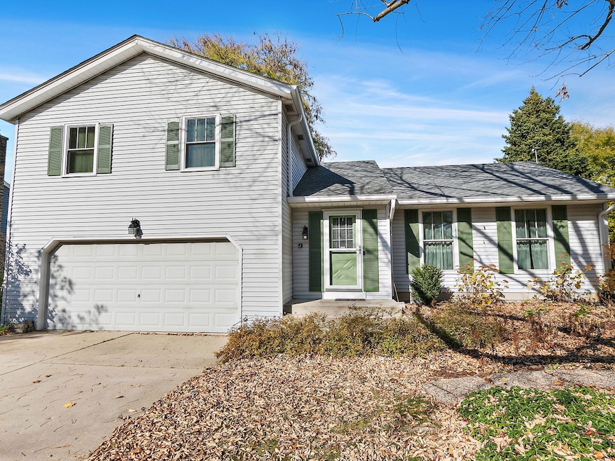
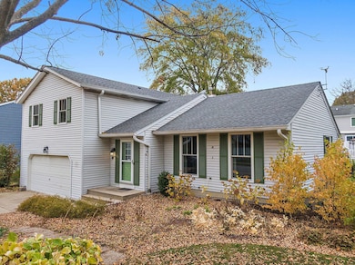
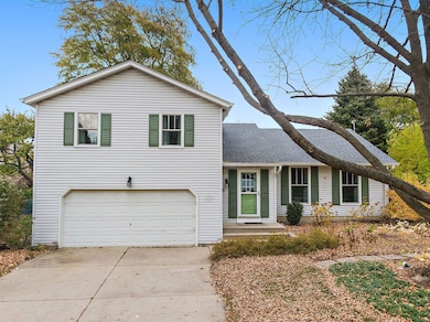

517 Sheffield Rd Naperville, IL 60565
Naper Carriage Hill NeighborhoodEstimated payment $3,254/month
Highlights
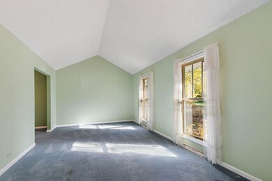
- Vaulted Ceiling
- Wood Flooring
- Soaking Tub
- Scott Elementary School Rated A
- Formal Dining Room
- Living Room
About This Home
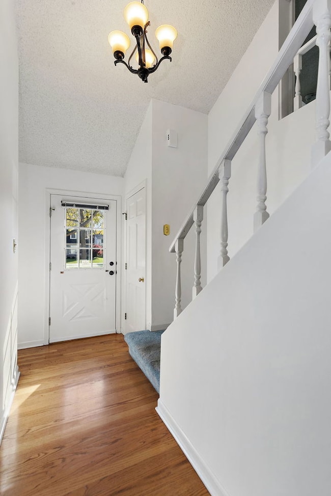
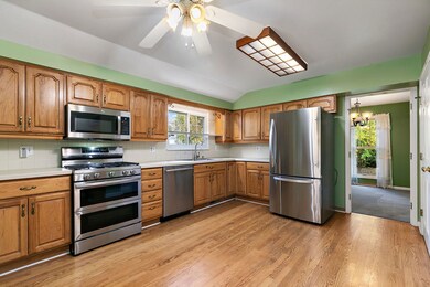
Well-maintained one-owner 3-bedroom split-level home in desirable Naper Carriage in Naperville~ within Top Rated Naperville 203 School District. Step into the inviting living room with vaulted ceilings and abundant natural light, flowing into the formal dining room with a pass-through to the kitchen. The kitchen features newer stainless steel appliances, hardwood flooring, a large pantry with built-in organizers, and space to add an island if desired. The upper level offers a primary bedroom with an en-suite bath, two additional bedrooms, a full bath with whirlpool tub, and a convenient laundry closet. The lower level includes a spacious family room with a sliding door to the backyard. A partially finished basement provides additional living space with a versatile bonus room ideal as a rec room or potential 4th bedroom, along with ample storage. Outside, enjoy a large backyard with room to add a patio or outdoor entertaining area. New roof in 2025 with gutter leaf filter. Prime location near shopping, restaurants, Block 59, parks, Naperville Public Library, and easy interstate access.
Listing Agent
Legacy Properties, A Sarah Leonard Company, LLC License #475122634 Listed on: 11/07/2025
Home Details
Home Type
- Single Family
Est. Annual Taxes
- $8,378
Year Built
- Built in 1976
Parking
- 2 Car Garage
Home Design
- Split Level Home
- Asphalt Roof
- Concrete Perimeter Foundation
Interior Spaces
- 2,258 Sq Ft Home
- Vaulted Ceiling
- Family Room
- Living Room
- Formal Dining Room
Kitchen
- Range
- Microwave
- Dishwasher
Flooring
- Wood
- Carpet
Bedrooms and Bathrooms
- 3 Bedrooms
- 3 Potential Bedrooms
- 2 Full Bathrooms
- Soaking Tub
- Separate Shower
Laundry
- Laundry Room
- Dryer
- Washer
Basement
- Partial Basement
- Sump Pump
Schools
- Scott Elementary School
- Madison Junior High School
- Naperville Central High School
Utilities
- Central Air
- Heating System Uses Natural Gas
- Satellite Dish
Additional Features
- Shed
- 10,019 Sq Ft Lot
Community Details
- Naper Carriage Hill Subdivision
Listing and Financial Details
- Senior Tax Exemptions
- Homeowner Tax Exemptions
Map
Home Values in the Area
Average Home Value in this Area
Tax History
| Year | Tax Paid | Tax Assessment Tax Assessment Total Assessment is a certain percentage of the fair market value that is determined by local assessors to be the total taxable value of land and additions on the property. | Land | Improvement |
|---|---|---|---|---|
| 2024 | $8,378 | $152,752 | $72,470 | $80,282 |
| 2023 | $8,019 | $139,410 | $66,140 | $73,270 |
| 2022 | $7,491 | $126,740 | $60,130 | $66,610 |
| 2021 | $7,202 | $121,950 | $57,860 | $64,090 |
| 2020 | $7,041 | $119,760 | $56,820 | $62,940 |
| 2019 | $6,818 | $114,580 | $54,360 | $60,220 |
| 2018 | $7,053 | $118,120 | $56,040 | $62,080 |
| 2017 | $6,897 | $114,140 | $54,150 | $59,990 |
| 2016 | $6,744 | $110,010 | $52,190 | $57,820 |
| 2015 | $6,675 | $103,600 | $49,150 | $54,450 |
| 2014 | $6,066 | $92,500 | $43,880 | $48,620 |
| 2013 | $5,977 | $92,730 | $43,990 | $48,740 |
Property History
| Date | Event | Price | List to Sale | Price per Sq Ft |
|---|---|---|---|---|
| 11/07/2025 11/07/25 | For Sale | $484,850 | -- | $215 / Sq Ft |
Purchase History
| Date | Type | Sale Price | Title Company |
|---|---|---|---|
| Interfamily Deed Transfer | -- | None Available |
Source: Midwest Real Estate Data (MRED)
MLS Number: 12511953
APN: 08-32-303-008
Disclaimer: Certain information contained herein is derived from information provided by parties other than Homes.com. All information provided is deemed reliable, but is not guaranteed to be accurate and should be independently verified.
![]() Based on information submitted to the MLS GRID. All data is obtained from various sources and may not have been verified by broker or MLS GRID. Supplied Open House Information is subject to change without notice. All information should be independently reviewed and verified for accuracy. Properties may or may not be listed by the office/agent presenting the information. Some IDX listings have been excluded from this website.
Based on information submitted to the MLS GRID. All data is obtained from various sources and may not have been verified by broker or MLS GRID. Supplied Open House Information is subject to change without notice. All information should be independently reviewed and verified for accuracy. Properties may or may not be listed by the office/agent presenting the information. Some IDX listings have been excluded from this website.
The Digital Millennium Copyright Act of 1998, 17 U.S.C. § 512 (the “DMCA”) provides recourse for copyright owners who believe that material appearing on the Internet infringes their rights under U.S. copyright law. If you believe in good faith that any content or material made available in connection with our website or services infringes your copyright, you (or your agent) may send us a notice requesting that the content or material be removed, or access to it blocked.
Notices must be sent in writing by email to DMCAnotice@MLSGrid.com.
The DMCA requires that your notice of alleged copyright infringement include the following information:
(1) description of the copyrighted work that is the subject of claimed infringement;
(2) description of the alleged infringing content and information sufficient to permit us to locate the content;
(3) contact information for you, including your address, telephone number and email address;
(4) a statement by you that you have a good faith belief that the content in the manner complained of is not authorized by the copyright owner, or its agent, or by the operation of any law;
(5) a statement by you, signed under penalty of perjury, that the information in the notification is accurate and that you have the authority to enforce the copyrights that are claimed to be infringed; and
(6) a physical or electronic signature of the copyright owner or a person authorized to act on the copyright owner’s behalf. Failure to include all of the above information may result in the delay of the processing of your complaint.
- 621 Bourbon Ct
- 431 Orleans Ave
- 302 Carriage Hill Rd
- 138 E Bailey Rd Unit M
- 158 E Bailey Rd Unit F
- 144 E Bailey Rd Unit L
- 456 Timber Trail Ct
- 336 Brooklea Ct
- 128 E Bailey Rd Unit G
- 1751 S Washington St Unit 1
- 1721 S Washington St Unit 1721
- 614 Bakewell Ln
- 1625 Indian Knoll Rd
- 805 Potomac Ave
- 816 Spindletree Ave
- 1921 Wisteria Ct Unit 3
- 705 Potomac Ave
- 1449 Whitespire Ct Unit 5104
- 2280 Barth Dr
- 47 Glencoe Ct Unit 102D
- 264 E Bailey Rd Unit E
- 1669 Ishnala Dr
- 228 E Bailey Rd Unit H
- 1665 Coach Dr Unit 204
- 428 E Bailey Rd Unit 203
- 412 E Bailey Rd Unit 104
- 1821 S Washington St
- 108 E Bailey Rd Unit M
- 43 Foxcroft Rd Unit 115
- 1309 Monmouth Ave
- 1308 Auburn Ave
- 1420 Auburn Ave Unit ID1285078P
- 1440 Carleton Ave
- 1915 Farmington Ct
- 1716 Rutgers Ct Unit ID1285014P
- 1931 Ridgefield Ln
- 2080 Springside Dr
- 291 Weatherford Ln Unit ID1285055P
- 1234 Stonebriar Ct
- 303 Danbury Dr Unit ID1285015P
