Estimated Value: $351,000 - $388,000
4
Beds
2
Baths
2,104
Sq Ft
$177/Sq Ft
Est. Value
About This Home
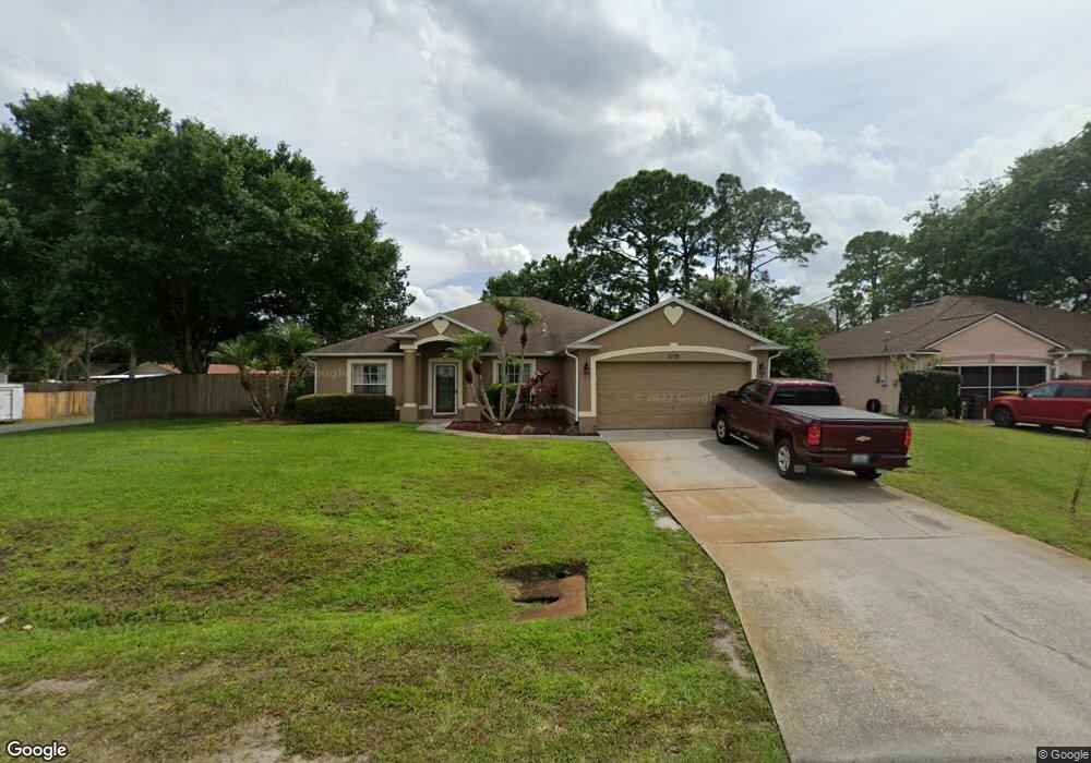
This home is located at 5175 Carter St, Cocoa, FL 32927 and is currently estimated at $372,227, approximately $176 per square foot. 5175 Carter St is a home located in Brevard County with nearby schools including Atlantis Elementary School, Space Coast Junior/Senior High School, and Sculptor Charter School.
Ownership History
Date
Name
Owned For
Owner Type
Purchase Details
Closed on
Dec 7, 2020
Sold by
Ferreri Robert C and Ferreri Denise M
Bought by
Ferreri Denise M
Current Estimated Value
Purchase Details
Closed on
Apr 11, 2005
Sold by
Burns Bryan R and Burns Lori N
Bought by
Ferreri Robert and Ferreri Denise
Home Financials for this Owner
Home Financials are based on the most recent Mortgage that was taken out on this home.
Original Mortgage
$201,960
Outstanding Balance
$103,949
Interest Rate
5.74%
Estimated Equity
$268,278
Purchase Details
Closed on
May 28, 1999
Sold by
Mercedes Homes Inc
Bought by
Burns Bryan R and Burns Lori N
Home Financials for this Owner
Home Financials are based on the most recent Mortgage that was taken out on this home.
Original Mortgage
$87,000
Interest Rate
6.84%
Purchase Details
Closed on
Mar 3, 1999
Sold by
Burns Bryan R and Burns Lori N
Bought by
Mercedes Homes Inc
Purchase Details
Closed on
May 19, 1998
Sold by
Alonso Rosa Maria and Alonso Javier M
Bought by
Burns Bryan R and Burns Lori N
Create a Home Valuation Report for This Property
The Home Valuation Report is an in-depth analysis detailing your home's value as well as a comparison with similar homes in the area
Home Values in the Area
Average Home Value in this Area
Purchase History
| Date | Buyer | Sale Price | Title Company |
|---|---|---|---|
| Ferreri Denise M | -- | None Available | |
| Ferreri Robert | $252,500 | B D R Title Corporation | |
| Burns Bryan R | $104,900 | -- | |
| Mercedes Homes Inc | $8,500 | -- | |
| Burns Bryan R | $8,500 | -- |
Source: Public Records
Mortgage History
| Date | Status | Borrower | Loan Amount |
|---|---|---|---|
| Open | Ferreri Robert | $201,960 | |
| Previous Owner | Burns Bryan R | $87,000 |
Source: Public Records
Tax History
| Year | Tax Paid | Tax Assessment Tax Assessment Total Assessment is a certain percentage of the fair market value that is determined by local assessors to be the total taxable value of land and additions on the property. | Land | Improvement |
|---|---|---|---|---|
| 2025 | $1,667 | $118,010 | -- | -- |
| 2024 | $1,625 | $114,690 | -- | -- |
| 2023 | $1,625 | $111,240 | $0 | $0 |
| 2022 | $1,519 | $108,000 | $0 | $0 |
| 2021 | $1,521 | $104,860 | $0 | $0 |
| 2020 | $1,445 | $103,420 | $0 | $0 |
| 2019 | $1,381 | $101,100 | $0 | $0 |
| 2018 | $1,374 | $99,220 | $0 | $0 |
| 2017 | $1,367 | $97,180 | $0 | $0 |
| 2016 | $1,371 | $95,190 | $18,000 | $77,190 |
| 2015 | $1,389 | $94,530 | $15,000 | $79,530 |
| 2014 | $1,391 | $93,780 | $11,000 | $82,780 |
Source: Public Records
Map
Nearby Homes
- 5155 Mayflower St
- 5165 Patricia St
- 5075 Carter St
- 5080 Mayflower St
- 6990 Bryant Rd
- 6815 Bryant Rd
- 6760 Cairo Rd
- 7065 Hundred Acre Dr
- 5200 Frisco St
- 7045 Grissom Pkwy
- 7155 Export Ave
- 5555 Brandon St
- 5150 Melody St
- 7230 Venus Ave
- 6620 Grissom Pkwy
- 7245 Grissom Pkwy
- 6615 Dock Ave
- 4824 Curtis Blvd
- 7635 Fringe Place
- 00 Unknown
- 5185 Carter St
- 5155 Carter St
- 6872 Buxton Ave
- 5170 Carter St
- 5195 Carter St
- 7017 Holly Ave
- 5160 Carter St
- 6873 Buxton Ave
- 5145 Carter St
- 5150 Carter St
- 6864 Buxton Ave
- 7025 Holly Ave
- 5140 Market St
- 7008 Holly Ave
- 5140 Carter St
- 5185 Mayflower St
- 5175 Mayflower St
- 5135 Carter St
- 5130 Market St
- 0 Mayflower Holly
Your Personal Tour Guide
Ask me questions while you tour the home.