
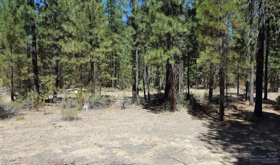
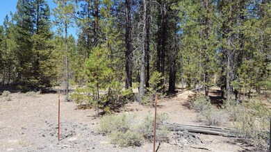
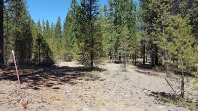
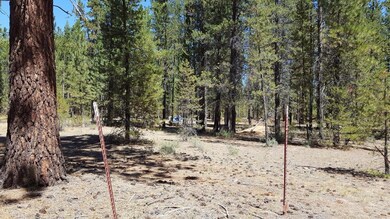
51839 Pine Loop Dr La Pine, OR 97739
0.98
Acre
$36,224
Price per Acre
42,689
Sq Ft Lot
About This Lot
As of February 2021Nice lot! Septic has been approved for an ATT system. Well already in place and 100 amp power.
Last Agent to Sell the Property
Gould & Associates Realty License #200302085 Listed on: 08/10/2016
Property Details
Property Type
- Land
Est. Annual Taxes
- $275
Lot Details
- 0.98 Acre Lot
- Property is zoned RR10, RR10
Schools
- Rosland Elementary School
- Lapine Middle School
- Lapine Sr High School
Additional Features
- Territorial Views
- Well
Community Details
- No Home Owners Association
- Ponderosa Pines East Subdivision
Listing and Financial Details
- Tax Lot 9
- Assessor Parcel Number 114811
Ownership History
Date
Name
Owned For
Owner Type
Purchase Details
Closed on
Jul 24, 2024
Sold by
Hjorth Frank William and Hjorth Kip William
Bought by
Hjorth Frank William and Hjorth Kip William
Current Estimated Value
Home Financials for this Owner
Home Financials are based on the most recent Mortgage that was taken out on this home.
Original Mortgage
$98,000
Outstanding Balance
$97,338
Interest Rate
6.95%
Mortgage Type
New Conventional
Estimated Equity
$339,307
Purchase Details
Listed on
Feb 26, 2020
Closed on
Feb 17, 2021
Sold by
Humphreys James and Humphreys Brenda
Bought by
Hjorth Frank William and Hjorth Kip William
Seller's Agent
Donna Werner
Crescent Lake Realty, Inc
Buyer's Agent
Donna Werner
Crescent Lake Realty, Inc
List Price
$125,000
Sold Price
$85,000
Premium/Discount to List
-$40,000
-32%
Home Financials for this Owner
Home Financials are based on the most recent Mortgage that was taken out on this home.
Avg. Annual Appreciation
45.93%
Purchase Details
Listed on
Aug 10, 2016
Closed on
Sep 30, 2016
Sold by
Campbell Teddy Noel
Bought by
Humphreys James
Seller's Agent
JoAnn Gould
Gould & Associates Realty
Buyer's Agent
JoAnn Gould
Gould & Associates Realty
List Price
$35,500
Sold Price
$35,500
Home Financials for this Owner
Home Financials are based on the most recent Mortgage that was taken out on this home.
Avg. Annual Appreciation
22.06%
Original Mortgage
$32,500
Interest Rate
3.43%
Mortgage Type
Seller Take Back
Purchase Details
Closed on
Jul 24, 2014
Sold by
Stormberg Randall Thomas
Bought by
Campbell Teddy Noel
Purchase Details
Closed on
Aug 23, 2005
Sold by
Current Albert Lee
Bought by
Moore Everett M and Moore Deborah J
Similar Property in La Pine, OR
Create a Home Valuation Report for This Property
The Home Valuation Report is an in-depth analysis detailing your home's value as well as a comparison with similar homes in the area
Home Values in the Area
Average Home Value in this Area
Purchase History
| Date | Type | Sale Price | Title Company |
|---|---|---|---|
| Bargain Sale Deed | -- | None Listed On Document | |
| Warranty Deed | $85,000 | Amerititle | |
| Warranty Deed | $35,500 | Amerititle | |
| Warranty Deed | $27,500 | First American Title | |
| Warranty Deed | $10,000 | Western Title & Escrow Co |
Source: Public Records
Mortgage History
| Date | Status | Loan Amount | Loan Type |
|---|---|---|---|
| Open | $98,000 | New Conventional | |
| Previous Owner | $80,000 | New Conventional | |
| Previous Owner | $32,500 | Seller Take Back |
Source: Public Records
Property History
| Date | Event | Price | Change | Sq Ft Price |
|---|---|---|---|---|
| 02/18/2021 02/18/21 | Sold | $85,000 | -14.1% | -- |
| 01/07/2021 01/07/21 | Price Changed | $99,000 | +16.5% | -- |
| 01/05/2021 01/05/21 | Pending | -- | -- | -- |
| 08/27/2020 08/27/20 | Off Market | $85,000 | -- | -- |
| 03/18/2020 03/18/20 | Price Changed | $119,000 | -4.8% | -- |
| 02/26/2020 02/26/20 | For Sale | $125,000 | +252.1% | -- |
| 10/05/2016 10/05/16 | Sold | $35,500 | 0.0% | -- |
| 09/06/2016 09/06/16 | Pending | -- | -- | -- |
| 08/10/2016 08/10/16 | For Sale | $35,500 | -- | -- |
Source: Oregon Datashare
Tax History Compared to Growth
Tax History
| Year | Tax Paid | Tax Assessment Tax Assessment Total Assessment is a certain percentage of the fair market value that is determined by local assessors to be the total taxable value of land and additions on the property. | Land | Improvement |
|---|---|---|---|---|
| 2024 | $2,516 | $139,930 | -- | -- |
| 2023 | $2,385 | $135,860 | $0 | $0 |
| 2022 | $748 | $23,200 | $0 | $0 |
| 2021 | $350 | $22,530 | $0 | $0 |
| 2020 | $332 | $22,530 | $0 | $0 |
| 2019 | $324 | $21,880 | $0 | $0 |
| 2018 | $316 | $21,250 | $0 | $0 |
| 2017 | $296 | $20,640 | $0 | $0 |
| 2016 | $282 | $20,040 | $0 | $0 |
| 2015 | $275 | $19,460 | $0 | $0 |
| 2014 | $267 | $18,900 | $0 | $0 |
Source: Public Records
Agents Affiliated with this Home
-
Donna Werner
Seller's Agent in 2021
Donna Werner
Crescent Lake Realty, Inc
(541) 480-3373
1 in this area
288 Total Sales
-
JoAnn Gould
Seller's Agent in 2016
JoAnn Gould
Gould & Associates Realty
(541) 480-3115
86 in this area
175 Total Sales
-
Elizabeth Frias
E
Seller Co-Listing Agent in 2016
Elizabeth Frias
Gould & Associates Realty
(541) 588-0449
85 in this area
157 Total Sales
Map
Source: Oregon Datashare
MLS Number: 201608243
APN: 114811
Disclaimer: Certain information contained herein is derived from information provided by parties other than Homes.com. All information provided is deemed reliable, but is not guaranteed to be accurate and should be independently verified.
![]() © 2025 Oregon Datashare (KCAR | MLSCO | SOMLS). All rights reserved. The data relating to real estate for sale on this web site comes in part from the Internet Data Exchange Program of the Oregon Datashare. Real estate listings held by IDX Brokerage firms other than Ten-X are marked with the Internet Data Exchange logo or the Internet Data Exchange thumbnail logo and detailed information about them includes the name of the listing Brokers. Information provided is for consumers' personal, non-commercial use and may not be used for any purpose other than to identify prospective properties the viewer may be interested in purchasing. The consumer will not copy, retransmit nor redistribute any of the content from this website. Information provided is deemed reliable, but not guaranteed.
© 2025 Oregon Datashare (KCAR | MLSCO | SOMLS). All rights reserved. The data relating to real estate for sale on this web site comes in part from the Internet Data Exchange Program of the Oregon Datashare. Real estate listings held by IDX Brokerage firms other than Ten-X are marked with the Internet Data Exchange logo or the Internet Data Exchange thumbnail logo and detailed information about them includes the name of the listing Brokers. Information provided is for consumers' personal, non-commercial use and may not be used for any purpose other than to identify prospective properties the viewer may be interested in purchasing. The consumer will not copy, retransmit nor redistribute any of the content from this website. Information provided is deemed reliable, but not guaranteed.
Nearby Homes
- 51862 Pine Loop Dr
- 51865 Pine Loop Dr
- 51589 Dorrance Meadow Rd
- 51590 Dorrance Meadow Rd
- 15471 Ferndale Ct
- 52027 Dustan Rd
- 52050 Dustan Rd
- 15734 Paulina Ave
- 15709 Davis Ave
- 51919 Kiwa Ln
- 51905 Kiwa Ln
- 0 Willow St Unit Lot 9 Block 6
- 51616 Pine Loop Dr
- 51596 Dorrance Meadow Rd
- 15522 Deer Ave Unit 9
- 15516 Deer Ave
- 15735 Blue Bird Ln
- 15505 Deer Ave
- 51581 Dorrance Meadow Rd
- 52180 Dorrance Meadow Rd