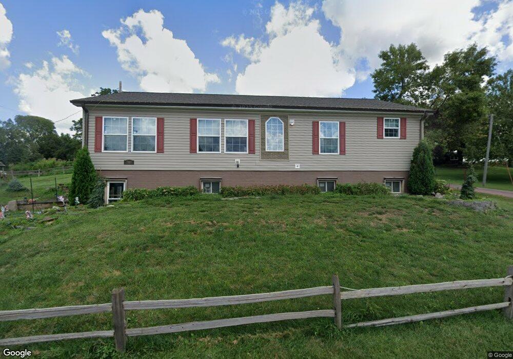
519 3rd St Mc Clelland, IA 51548
Estimated Value: $275,730 - $566,000
3
Beds
2
Baths
1,500
Sq Ft
$251/Sq Ft
Est. Value
About This Home
This home is located at 519 3rd St, Mc Clelland, IA 51548 and is currently estimated at $376,577, approximately $251 per square foot. 519 3rd St is a home located in Pottawattamie County with nearby schools including Underwood Elementary School, Underwood Middle School, and Underwood High School.
Ownership History
Date
Name
Owned For
Owner Type
Purchase Details
Closed on
Jun 30, 2010
Sold by
Magnuson Karen J
Bought by
Magnuson Denise D
Current Estimated Value
Purchase Details
Closed on
Aug 17, 2007
Sold by
Magnuson Terry and Magnuson Kristine
Bought by
Magnuson Karen and Magnuson Denise
Purchase Details
Closed on
May 16, 2007
Sold by
George Cindy Marie and Scott Cindy Marie
Bought by
Scott Cindy Marie
Create a Home Valuation Report for This Property
The Home Valuation Report is an in-depth analysis detailing your home's value as well as a comparison with similar homes in the area
Home Values in the Area
Average Home Value in this Area
Purchase History
| Date | Buyer | Sale Price | Title Company |
|---|---|---|---|
| Magnuson Denise D | -- | None Available | |
| Magnuson Karen | -- | None Available | |
| Scott Cindy Marie | -- | None Available |
Source: Public Records
Tax History Compared to Growth
Tax History
| Year | Tax Paid | Tax Assessment Tax Assessment Total Assessment is a certain percentage of the fair market value that is determined by local assessors to be the total taxable value of land and additions on the property. | Land | Improvement |
|---|---|---|---|---|
| 2025 | $3,164 | $243,700 | $33,800 | $209,900 |
| 2024 | $3,164 | $217,400 | $29,400 | $188,000 |
| 2023 | $3,016 | $215,500 | $29,400 | $186,100 |
| 2022 | $1,192 | $189,200 | $25,600 | $163,600 |
| 2021 | $1,647 | $69,300 | $25,600 | $43,700 |
| 2020 | $898 | $50,300 | $12,600 | $37,700 |
| 2019 | $762 | $50,300 | $12,600 | $37,700 |
| 2018 | $750 | $41,200 | $7,393 | $33,807 |
| 2017 | $770 | $41,200 | $7,393 | $33,807 |
| 2015 | $602 | $33,191 | $7,393 | $25,798 |
| 2014 | $598 | $33,191 | $7,393 | $25,798 |
Source: Public Records
Map
Nearby Homes
- 21693 270th St
- LOT 2 Stoneridge Ct
- LOT 1 Stoneridge Ct
- LOT 5 Stoneridge Ct
- LOT 10 Stoneridge Ct
- LOT 8 Stoneridge Ct
- LOT 9 Stoneridge Ct
- LOT 7 Stoneridge Ct
- 16 4th Ave
- 22767 County Road L34
- 23973 Dogwood Rd
- 22395 205th St
- 21836 Vineyard Hills Dr
- 12C Road L34
- 12B Road L34
- 25440 County Road L34
- 4 AC M/L 210th St
- 25514 Greenview Rd
- 15725 300th St
- 24174 205th St