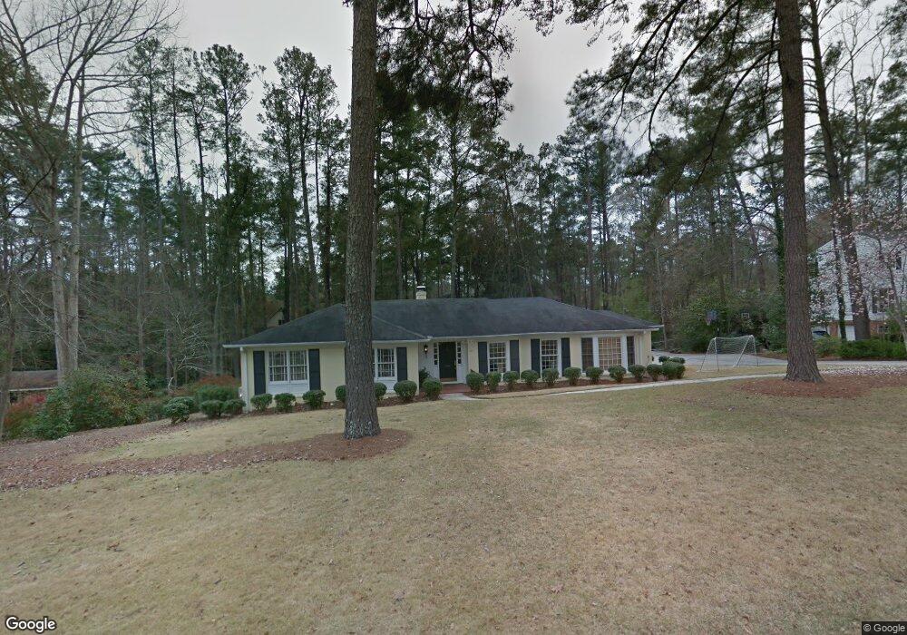
519 Scotts Way Augusta, GA 30909
West Augusta NeighborhoodEstimated Value: $421,874 - $487,000
4
Beds
3
Baths
2,553
Sq Ft
$174/Sq Ft
Est. Value
About This Home
This home is located at 519 Scotts Way, Augusta, GA 30909 and is currently estimated at $443,219, approximately $173 per square foot. 519 Scotts Way is a home located in Richmond County with nearby schools including First Coast Technical Institute, R.B. Hunt Elementary School, and Lake Forest Hills Elementary School.
Ownership History
Date
Name
Owned For
Owner Type
Purchase Details
Closed on
Jun 23, 2003
Sold by
Patrick Roy C
Bought by
Campbell Robert A and Campbell Renee S
Current Estimated Value
Home Financials for this Owner
Home Financials are based on the most recent Mortgage that was taken out on this home.
Original Mortgage
$162,000
Outstanding Balance
$69,830
Interest Rate
5.56%
Mortgage Type
Purchase Money Mortgage
Estimated Equity
$373,389
Purchase Details
Closed on
Jul 30, 1990
Sold by
Patrick Dorothy M
Bought by
Patrick Roy C
Create a Home Valuation Report for This Property
The Home Valuation Report is an in-depth analysis detailing your home's value as well as a comparison with similar homes in the area
Home Values in the Area
Average Home Value in this Area
Purchase History
| Date | Buyer | Sale Price | Title Company |
|---|---|---|---|
| Campbell Robert A | $202,500 | -- | |
| Patrick Roy C | -- | -- |
Source: Public Records
Mortgage History
| Date | Status | Borrower | Loan Amount |
|---|---|---|---|
| Open | Campbell Robert A | $162,000 |
Source: Public Records
Tax History Compared to Growth
Tax History
| Year | Tax Paid | Tax Assessment Tax Assessment Total Assessment is a certain percentage of the fair market value that is determined by local assessors to be the total taxable value of land and additions on the property. | Land | Improvement |
|---|---|---|---|---|
| 2025 | $4,533 | $156,200 | $28,000 | $128,200 |
| 2024 | $4,533 | $152,284 | $28,000 | $124,284 |
| 2023 | $2,908 | $122,608 | $28,000 | $94,608 |
| 2022 | $3,697 | $122,882 | $28,000 | $94,882 |
| 2021 | $3,917 | $119,573 | $28,000 | $91,573 |
| 2020 | $3,490 | $107,628 | $28,000 | $79,628 |
| 2019 | $3,716 | $107,628 | $28,000 | $79,628 |
| 2018 | $3,744 | $107,628 | $28,000 | $79,628 |
| 2017 | $3,706 | $107,628 | $28,000 | $79,628 |
| 2016 | $3,709 | $107,628 | $28,000 | $79,628 |
| 2015 | $3,737 | $107,628 | $28,000 | $79,628 |
| 2014 | $3,742 | $107,628 | $28,000 | $79,628 |
Source: Public Records
Map
Nearby Homes
- 509 Winchester Dr
- 506 Regent Place
- 3222 Ramsgate Rd
- 3218 Ramsgate Rd
- 5 Prather Woods Ln
- 605 Regent Rd
- 3144 Edinburgh Dr
- 538 Regent Rd
- 629 Canterbury Dr
- 3129 Edinburgh Dr
- 3129 Ramsgate Rd
- 3121 Ramsgate Rd
- 3125 Exeter Rd
- 3122 Sussex Rd
- 3307 Somerset Place
- 3204 Wheeler Rd
- 3344 Wheeler Rd
- 3118 Exeter Rd
- 3116 Exeter Rd
- 745 Oxford Rd
- 521 Scotts Way
- 517 Scotts Way
- 516 Winchester Dr
- 518 Winchester Dr
- 514 Winchester Dr
- 526 Scotts Way
- 515 Scotts Way
- 528 Scotts Way
- 601 Norwich Rd
- 530 Scotts Way
- 512 Winchester Dr
- 520 Winchester Dr
- 518 Scotts Way
- 515 Norwich Rd
- 524 Scotts Way
- 513 Scotts Way
- 517 Winchester Dr
- 519 Winchester Dr
- 510 Winchester Dr
- 515 Winchester Dr