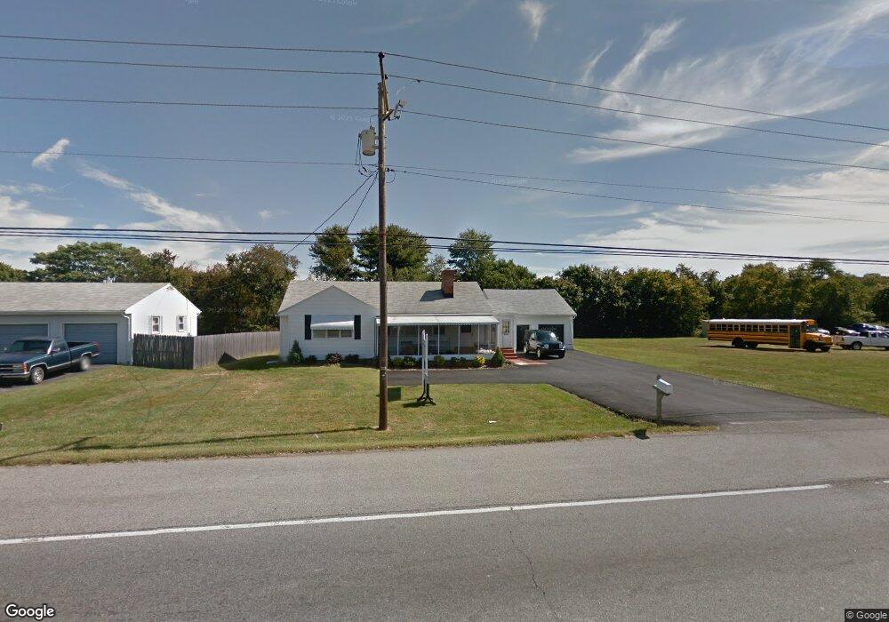
5197 Summit Bridge Rd Middletown, DE 19709
Estimated Value: $305,000 - $358,000
3
Beds
1
Bath
1,224
Sq Ft
$270/Sq Ft
Est. Value
About This Home
This home is located at 5197 Summit Bridge Rd, Middletown, DE 19709 and is currently estimated at $330,221, approximately $269 per square foot. 5197 Summit Bridge Rd is a home located in New Castle County with nearby schools including Bunker Hill Elementary School, Everett Meredith Middle School, and Appoquinimink High School.
Ownership History
Date
Name
Owned For
Owner Type
Purchase Details
Closed on
Sep 17, 2007
Sold by
Saxton Joseph P and Sapp Marie A
Bought by
Ckq Properties Llc
Current Estimated Value
Home Financials for this Owner
Home Financials are based on the most recent Mortgage that was taken out on this home.
Original Mortgage
$206,000
Outstanding Balance
$131,292
Interest Rate
6.7%
Mortgage Type
Purchase Money Mortgage
Estimated Equity
$198,929
Purchase Details
Closed on
Sep 16, 2005
Sold by
Johnson Edna H and Edwards Ronald W
Bought by
Saxton Joseph P and Sapp Marie A
Home Financials for this Owner
Home Financials are based on the most recent Mortgage that was taken out on this home.
Original Mortgage
$146,048
Interest Rate
7.4%
Mortgage Type
Purchase Money Mortgage
Create a Home Valuation Report for This Property
The Home Valuation Report is an in-depth analysis detailing your home's value as well as a comparison with similar homes in the area
Home Values in the Area
Average Home Value in this Area
Purchase History
| Date | Buyer | Sale Price | Title Company |
|---|---|---|---|
| Ckq Properties Llc | $257,500 | None Available | |
| Saxton Joseph P | $182,560 | -- |
Source: Public Records
Mortgage History
| Date | Status | Borrower | Loan Amount |
|---|---|---|---|
| Open | Ckq Properties Llc | $206,000 | |
| Previous Owner | Saxton Joseph P | $146,048 |
Source: Public Records
Tax History Compared to Growth
Tax History
| Year | Tax Paid | Tax Assessment Tax Assessment Total Assessment is a certain percentage of the fair market value that is determined by local assessors to be the total taxable value of land and additions on the property. | Land | Improvement |
|---|---|---|---|---|
| 2024 | $1,954 | $46,700 | $5,900 | $40,800 |
| 2023 | $1,661 | $46,700 | $5,900 | $40,800 |
| 2022 | $1,673 | $46,700 | $5,900 | $40,800 |
| 2021 | $1,652 | $46,700 | $5,900 | $40,800 |
| 2020 | $1,633 | $46,700 | $5,900 | $40,800 |
| 2019 | $1,512 | $46,700 | $5,900 | $40,800 |
| 2018 | $1,456 | $46,700 | $5,900 | $40,800 |
| 2017 | $1,394 | $46,700 | $5,900 | $40,800 |
| 2016 | $1,274 | $46,700 | $5,900 | $40,800 |
| 2015 | $1,239 | $46,700 | $5,900 | $40,800 |
| 2014 | $1,236 | $46,700 | $5,900 | $40,800 |
Source: Public Records
Map
Nearby Homes
- 5165 Summit Bridge Rd
- 574 Whispering Trail
- 577 Whispering Trail
- 51 Springmill Dr
- 580 Whispering Trail
- 12 Demaret Ct
- 56 Springmill Dr
- 415 Morning Glory Ln
- 417 Morning Glory Ln
- 65 W Sarazen Dr
- 20 Palmer Dr
- 120 Betsy Rawls Dr
- 343 Daylilly Way
- 102 Springmill Dr
- 306 E Harvest Ln
- 335 Marldale Dr
- 367 E Harvest Ln
- 365 Andrew Ct
- 434 Spring Hollow Dr
- 6 Kimberly Dr
- 5193 Summit Bridge Rd
- 5207 Summit Bridge Rd
- 5187 Summit Bridge Rd
- 538 Whispering Trail
- 534 Whispering Trail
- 540 Whispering Trail
- 536 Whispering Trail
- 542 Whispering Trail
- 5160 Summit Bridge Rd
- 532 Whispering Trail
- 544 Whispering Trail
- 12 Couples Ct
- 5169 Summit Bridge Rd
- 546 Whispering Trail
- 530 Whispering Trail
- 537 Whispering Trail
- 30 Snead Cir
- 13 Couples Ct
- 541 Whispering Trail
- 533 Whispering Trail