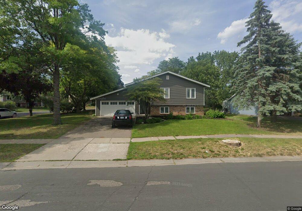
5201 142nd Path W Saint Paul, MN 55124
Estimated Value: $332,000 - $401,000
3
Beds
2
Baths
977
Sq Ft
$383/Sq Ft
Est. Value
About This Home
This home is located at 5201 142nd Path W, Saint Paul, MN 55124 and is currently estimated at $374,526, approximately $383 per square foot. 5201 142nd Path W is a home located in Dakota County with nearby schools including Diamond Path Elementary School of International Studies, Scott Highlands Middle School, and Eastview Senior High School.
Ownership History
Date
Name
Owned For
Owner Type
Purchase Details
Closed on
Aug 31, 2018
Sold by
Tompkins John Michael and Estate Of Patrick L Tompkins
Bought by
Tompkins Charles P and Crooks Joan M
Current Estimated Value
Create a Home Valuation Report for This Property
The Home Valuation Report is an in-depth analysis detailing your home's value as well as a comparison with similar homes in the area
Home Values in the Area
Average Home Value in this Area
Purchase History
| Date | Buyer | Sale Price | Title Company |
|---|---|---|---|
| Tompkins Charles P | $180,000 | Partners Title Llc |
Source: Public Records
Tax History Compared to Growth
Tax History
| Year | Tax Paid | Tax Assessment Tax Assessment Total Assessment is a certain percentage of the fair market value that is determined by local assessors to be the total taxable value of land and additions on the property. | Land | Improvement |
|---|---|---|---|---|
| 2024 | $3,782 | $320,000 | $89,500 | $230,500 |
| 2023 | $3,782 | $333,300 | $89,700 | $243,600 |
| 2022 | $3,326 | $330,000 | $89,400 | $240,600 |
| 2021 | $3,224 | $285,700 | $77,800 | $207,900 |
| 2020 | $3,044 | $270,800 | $74,100 | $196,700 |
| 2019 | $2,652 | $247,900 | $70,500 | $177,400 |
| 2018 | $2,505 | $237,400 | $67,200 | $170,200 |
| 2017 | $2,444 | $216,900 | $64,000 | $152,900 |
| 2016 | $2,396 | $202,600 | $60,900 | $141,700 |
| 2015 | $2,320 | $177,708 | $53,799 | $123,909 |
| 2014 | -- | $173,348 | $51,681 | $121,667 |
| 2013 | -- | $154,600 | $46,731 | $107,869 |
Source: Public Records
Map
Nearby Homes
- 14387 Embassy Way
- 13877 Elkhart Rd
- 13937 Ember Ct
- 5357 Upper 147th St W
- 5657 144th St W
- 14527 Eureka Ct
- 5167 148th St W
- 14757 Excelsior Ln Unit 105
- 14797 Lower Endicott Way
- 14720 Excelsior Ln Unit 28
- 14742 Endicott Way
- 5099 151st St W
- 13641 Everton Ave
- 22367 Denmark Ct
- 14554 Denver Ct
- 13573 Everton Ave
- 14162 Dearborn Path
- 14220 Davenport Path
- 13973 Falcon Ave
- 15056 Dunwood Trail Unit 19
- 5189 142nd Path W
- 14174 Elmira Ct
- 5237 142nd Path W
- 5171 142nd Path W
- 14183 Elmira Ct
- 5210 142nd Path W
- 14171 Elmira Ct
- 14168 Elmira Ct
- 5228 142nd Path W
- 5180 142nd Path W
- 14161 Elmira Ct
- 5253 142nd Path W
- 5151 142nd Path W
- 5244 142nd Path W
- 14181 Elgin Ct
- 5162 142nd Path W
- 14148 Elmira Ct
- 14147 Elmira Ct
- 5273 142nd Path W
- 14160 Ensley Ct