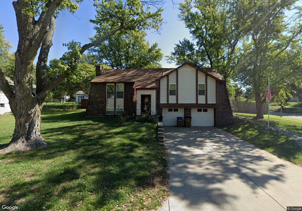
525 S Adams St Raymore, MO 64083
Estimated Value: $275,000 - $293,000
3
Beds
1
Bath
1,056
Sq Ft
$269/Sq Ft
Est. Value
About This Home
This home is located at 525 S Adams St, Raymore, MO 64083 and is currently estimated at $284,320, approximately $269 per square foot. 525 S Adams St is a home located in Cass County with nearby schools including Raymore Elementary School, Raymore-Peculiar East Middle School, and Raymore-Peculiar Senior High School.
Ownership History
Date
Name
Owned For
Owner Type
Purchase Details
Closed on
May 7, 2021
Sold by
Skaggs Wesley B and Skaggs Euleta F
Bought by
Skaggs Wesley B and Skaggs Euleta F
Current Estimated Value
Home Financials for this Owner
Home Financials are based on the most recent Mortgage that was taken out on this home.
Original Mortgage
$128,900
Interest Rate
6.95%
Mortgage Type
New Conventional
Purchase Details
Closed on
Mar 9, 2020
Sold by
Skaggs Wesley B and Skaggs Euleta F
Bought by
Penley Denise and Davis Jerry
Home Financials for this Owner
Home Financials are based on the most recent Mortgage that was taken out on this home.
Original Mortgage
$120,000
Interest Rate
3.5%
Mortgage Type
New Conventional
Create a Home Valuation Report for This Property
The Home Valuation Report is an in-depth analysis detailing your home's value as well as a comparison with similar homes in the area
Home Values in the Area
Average Home Value in this Area
Purchase History
| Date | Buyer | Sale Price | Title Company |
|---|---|---|---|
| Skaggs Wesley B | -- | -- |
Source: Public Records
Mortgage History
| Date | Status | Borrower | Loan Amount |
|---|---|---|---|
| Previous Owner | Skaggs Wesley B | $128,900 | |
| Previous Owner | Skaggs Wesley B | $120,000 | |
| Previous Owner | Skaggs Wesley B | $102,650 | |
| Previous Owner | Skaggs Wesley B | $87,630 | |
| Previous Owner | Skaggs Wesley B | $26,495 |
Source: Public Records
Tax History Compared to Growth
Tax History
| Year | Tax Paid | Tax Assessment Tax Assessment Total Assessment is a certain percentage of the fair market value that is determined by local assessors to be the total taxable value of land and additions on the property. | Land | Improvement |
|---|---|---|---|---|
| 2024 | $2,478 | $30,450 | $3,720 | $26,730 |
| 2023 | $2,475 | $30,450 | $3,720 | $26,730 |
| 2022 | $2,178 | $26,620 | $3,720 | $22,900 |
| 2021 | $2,178 | $26,620 | $3,720 | $22,900 |
| 2020 | $2,156 | $25,880 | $3,720 | $22,160 |
| 2019 | $2,081 | $25,880 | $3,720 | $22,160 |
| 2018 | $1,932 | $23,200 | $2,980 | $20,220 |
| 2017 | $1,694 | $23,200 | $2,980 | $20,220 |
| 2016 | $1,694 | $21,120 | $2,980 | $18,140 |
| 2015 | $1,696 | $21,120 | $2,980 | $18,140 |
| 2014 | $1,696 | $21,120 | $2,980 | $18,140 |
| 2013 | -- | $21,120 | $2,980 | $18,140 |
Source: Public Records
Map
Nearby Homes
- 714 Shiloh Dr
- 602 Sandpiper St
- 704 Canter St
- 807 S Franklin St
- 808 Crane St
- 200 S Park Dr
- 613 Lakeview Dr
- 612 Country Ln
- 211 S Sunset Ln
- 718 Sandpiper St
- 303 Shoreview Dr
- 222 N Madison St
- 218 N Washington St
- 409 S Lakeshore Dr
- 239 Jenny Ln
- 501 Chestnut Cir
- 225 N Woodson Dr
- 901 W Lucy Webb Rd
- 108 Rainbow Cir
- 814 Clancy Ct
- 524 S Washington St
- 521 S Adams St
- 522 S Washington St
- 524 S Adams St
- 522 S Adams St
- 601 S Adams St
- 318 W Cottonwood Dr
- 518 S Adams St
- 520 S Washington St
- 320 W Cottonwood Dr
- 519 S Adams St
- 603 S Adams St
- 316 W Cottonwood Dr
- 516 S Adams St
- 518 S Washington St
- 605 S Adams St
- 523 S Madison St
- 322 W Cottonwood Dr
- 517 S Adams St
- 525 S Washington St