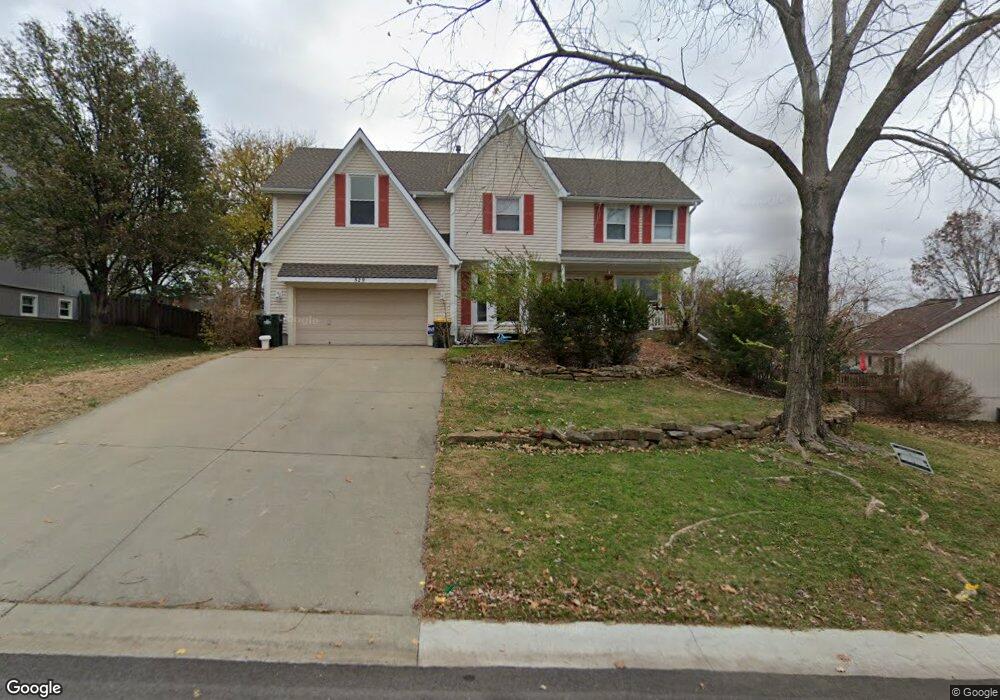
529 Bittersweet Rd Lansing, KS 66043
Estimated Value: $345,518 - $400,000
4
Beds
3
Baths
2,139
Sq Ft
$173/Sq Ft
Est. Value
About This Home
This home is located at 529 Bittersweet Rd, Lansing, KS 66043 and is currently estimated at $369,380, approximately $172 per square foot. 529 Bittersweet Rd is a home located in Leavenworth County with nearby schools including Lansing Elementary School, Lansing Middle 6-8, and Lansing High 9-12.
Ownership History
Date
Name
Owned For
Owner Type
Purchase Details
Closed on
May 30, 2019
Sold by
Pendergast Clinton R and Pendergast Joana
Bought by
Spears Charles and Spears Lori Ann
Current Estimated Value
Home Financials for this Owner
Home Financials are based on the most recent Mortgage that was taken out on this home.
Original Mortgage
$211,000
Outstanding Balance
$185,521
Interest Rate
4.1%
Mortgage Type
New Conventional
Estimated Equity
$183,859
Purchase Details
Closed on
Feb 1, 1999
Bought by
Pendergast Clinton R and Calin Joana
Create a Home Valuation Report for This Property
The Home Valuation Report is an in-depth analysis detailing your home's value as well as a comparison with similar homes in the area
Home Values in the Area
Average Home Value in this Area
Purchase History
| Date | Buyer | Sale Price | Title Company |
|---|---|---|---|
| Spears Charles | $280,630 | New Title Company Name | |
| Pendergast Clinton R | $152,000 | -- |
Source: Public Records
Mortgage History
| Date | Status | Borrower | Loan Amount |
|---|---|---|---|
| Open | Spears Charles | $211,000 |
Source: Public Records
Tax History
| Year | Tax Paid | Tax Assessment Tax Assessment Total Assessment is a certain percentage of the fair market value that is determined by local assessors to be the total taxable value of land and additions on the property. | Land | Improvement |
|---|---|---|---|---|
| 2025 | $4,603 | $38,352 | $5,373 | $32,979 |
| 2024 | $4,603 | $36,876 | $4,257 | $32,619 |
| 2023 | $4,603 | $35,458 | $4,257 | $31,201 |
| 2022 | $4,447 | $32,234 | $3,283 | $28,951 |
| 2021 | $4,447 | $30,877 | $3,283 | $27,594 |
| 2020 | $4,222 | $28,856 | $3,283 | $25,573 |
| 2019 | $4,122 | $28,140 | $3,283 | $24,857 |
| 2018 | $3,712 | $25,385 | $2,721 | $22,664 |
| 2017 | $3,562 | $24,321 | $2,721 | $21,600 |
| 2016 | $3,477 | $23,736 | $2,721 | $21,015 |
| 2015 | $3,467 | $23,736 | $2,721 | $21,015 |
| 2014 | -- | $23,299 | $2,721 | $20,578 |
Source: Public Records
Map
Nearby Homes
- 503 S 1st St
- 922 Southfork St
- 202 S Main St
- 124 S Main St
- 811 4-H Rd
- 26731 147th St
- 20958 Ida St
- 215 E Mary St
- 218 E Kay St
- 111 Southfork Rd
- 00000 Brookwood St
- 875 Clearview Dr
- 1221 S Desoto Rd
- 189 Canyon View Dr
- 1322 Rock Creek Ct
- 712 Rock Creek Dr
- 530 Holiday Ct
- 898 Clearview Dr
- 1313 Stone Ln
- 950 Holiday Dr
- 529 S Bittersweet Ln
- 525 Bittersweet Rd
- 336 Sage Rd
- 528 S Valley Dr
- 334 Sage Rd
- 532 S Valley Dr
- 532 S Bittersweet Ln
- 530 Bittersweet Rd
- 313 W Olive St
- 532 Bittersweet Rd
- 526 Bittersweet Rd
- 332 Sage Rd
- 311 W Olive St
- 332 Sage St
- 534 Bittersweet Rd
- 536 S Valley Dr
- 522 S Bittersweet Ln
- 522 Bittersweet Rd
- 335 Sage Rd
- 600 Bittersweet Rd
Your Personal Tour Guide
Ask me questions while you tour the home.