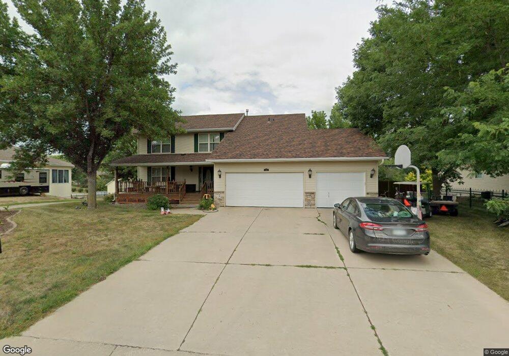
529 Deer Trail Montgomery, MN 56069
Estimated Value: $438,000 - $466,000
5
Beds
4
Baths
1,972
Sq Ft
$229/Sq Ft
Est. Value
About This Home
This home is located at 529 Deer Trail, Montgomery, MN 56069 and is currently estimated at $452,547, approximately $229 per square foot. 529 Deer Trail is a home located in Le Sueur County with nearby schools including Tri-City United Montgomery PreK-8, Tri-City United Lonsdale PreK-6 Elementary School, and Tri-City United High School.
Ownership History
Date
Name
Owned For
Owner Type
Purchase Details
Closed on
May 13, 2016
Bought by
Wolf Lucas Lucas
Current Estimated Value
Home Financials for this Owner
Home Financials are based on the most recent Mortgage that was taken out on this home.
Original Mortgage
$247,822
Outstanding Balance
$196,703
Interest Rate
3.57%
Estimated Equity
$255,844
Purchase Details
Closed on
May 21, 2014
Sold by
Allan P Allan P and Vlasak Janete M
Bought by
Vlasak Allan P
Create a Home Valuation Report for This Property
The Home Valuation Report is an in-depth analysis detailing your home's value as well as a comparison with similar homes in the area
Home Values in the Area
Average Home Value in this Area
Purchase History
| Date | Buyer | Sale Price | Title Company |
|---|---|---|---|
| Wolf Lucas Lucas | $255,000 | -- | |
| Vlasak Allan P | -- | -- |
Source: Public Records
Mortgage History
| Date | Status | Borrower | Loan Amount |
|---|---|---|---|
| Open | Wolf Lucas Lucas | $247,822 |
Source: Public Records
Tax History Compared to Growth
Tax History
| Year | Tax Paid | Tax Assessment Tax Assessment Total Assessment is a certain percentage of the fair market value that is determined by local assessors to be the total taxable value of land and additions on the property. | Land | Improvement |
|---|---|---|---|---|
| 2025 | $7,140 | $440,500 | $71,200 | $369,300 |
| 2024 | $6,600 | $440,500 | $71,200 | $369,300 |
| 2023 | $6,290 | $444,300 | $71,200 | $373,100 |
| 2022 | $5,500 | $410,800 | $71,200 | $339,600 |
| 2021 | $5,354 | $330,700 | $65,200 | $265,500 |
| 2020 | $5,248 | $319,300 | $65,200 | $254,100 |
| 2019 | $5,040 | $301,200 | $63,247 | $237,953 |
| 2018 | $5,025 | $276,200 | $62,616 | $213,584 |
| 2017 | $4,659 | $252,700 | $59,090 | $193,610 |
| 2016 | $4,702 | $228,200 | $54,543 | $173,657 |
| 2015 | $4,687 | $229,400 | $54,583 | $174,817 |
| 2014 | $4,035 | $181,100 | $48,100 | $133,000 |
| 2013 | $4,040 | $181,100 | $48,100 | $133,000 |
Source: Public Records
Map
Nearby Homes
- 600 Boulevard Ave NE
- 220 6th St NE
- 619 Fir Ave NE
- 218 6th St NE
- 900 Mulberry Ave NE
- 921 Mulberry Ave NE
- 900 Emily Ct NE
- 907 Emily Ct NE
- 305 Elm Ave SE
- 400 Elm Ave SE
- 903 Amelia Ct NE
- 912 Katelyn Cir
- 914 Katelyn Cir
- 907 Amelia Ct NE
- 105 N Circle Dr
- 1106 Mulberry Ave NE
- 1003 Mulberry Ave NE
- 911 Amelia Ct NE
- 901 14th St NE
- 1101 Mulberry Ave NE
- 525 Deer Trail
- 533 Deer Trail
- 509 Pheasant Run
- 521 Deer Trail
- 537 Deer Trail
- 508 Deer Trail
- 508 Pheasant Run
- 517 Deer Trail
- 505 Pheasant Run
- 541 Deer Trail
- 520 Deer Trail
- 504 Deer Trail
- 545 Deer Trail
- 504 Pheasant Run
- 513 Deer Trail
- 501 Pheasant Run
- 601 Deer Trail
- 500 Deer Trail
- 509 Deer Trail
- 609 Deer Trail