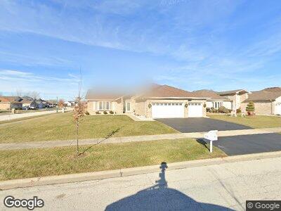
5300 Trinity Place Matteson, IL 60443
West Matteson NeighborhoodEstimated Value: $338,683 - $386,000
4
Beds
3
Baths
2,700
Sq Ft
$135/Sq Ft
Est. Value
About This Home
This home is located at 5300 Trinity Place, Matteson, IL 60443 and is currently estimated at $363,921, approximately $134 per square foot. 5300 Trinity Place is a home located in Cook County with nearby schools including Colin Powell Middle School.
Ownership History
Date
Name
Owned For
Owner Type
Purchase Details
Closed on
Mar 21, 2024
Sold by
Jordan Sharon Wyatt
Bought by
Love Each Other Legacy Revocable Living Trust
Current Estimated Value
Purchase Details
Closed on
Sep 7, 2004
Sold by
First Midwest Bank
Bought by
Wyatt Jordan Michael and Wyatt Jordan Sharon
Home Financials for this Owner
Home Financials are based on the most recent Mortgage that was taken out on this home.
Original Mortgage
$282,378
Interest Rate
6.17%
Mortgage Type
Unknown
Create a Home Valuation Report for This Property
The Home Valuation Report is an in-depth analysis detailing your home's value as well as a comparison with similar homes in the area
Home Values in the Area
Average Home Value in this Area
Purchase History
| Date | Buyer | Sale Price | Title Company |
|---|---|---|---|
| Love Each Other Legacy Revocable Living Trust | -- | None Listed On Document | |
| Wyatt Jordan Michael | $297,500 | Cti |
Source: Public Records
Mortgage History
| Date | Status | Borrower | Loan Amount |
|---|---|---|---|
| Previous Owner | Wyatt Jordan Michael | $282,378 |
Source: Public Records
Tax History Compared to Growth
Tax History
| Year | Tax Paid | Tax Assessment Tax Assessment Total Assessment is a certain percentage of the fair market value that is determined by local assessors to be the total taxable value of land and additions on the property. | Land | Improvement |
|---|---|---|---|---|
| 2024 | $6,286 | $29,586 | $6,876 | $22,710 |
| 2023 | $6,286 | $29,586 | $6,876 | $22,710 |
| 2022 | $6,286 | $17,900 | $5,938 | $11,962 |
| 2021 | $6,433 | $17,898 | $5,937 | $11,961 |
| 2020 | $6,970 | $18,930 | $5,937 | $12,993 |
| 2019 | $6,203 | $17,525 | $5,312 | $12,213 |
| 2018 | $6,107 | $17,525 | $5,312 | $12,213 |
| 2017 | $8,121 | $21,587 | $5,312 | $16,275 |
| 2016 | $8,699 | $19,307 | $4,687 | $14,620 |
| 2015 | $8,478 | $19,307 | $4,687 | $14,620 |
| 2014 | $8,274 | $19,307 | $4,687 | $14,620 |
| 2013 | $8,807 | $21,773 | $4,687 | $17,086 |
Source: Public Records
Map
Nearby Homes
- 161 Providence Dr
- 41 Manor Dr
- 175 Owen St
- 217 Owen St
- 5108 Monroe St
- 255 Central Ave
- 5522 Mallard Dr
- 71 Bowman St
- 5515 Mallard Dr
- 122 Lawrence Ln
- 5646 Feathercreek Rd
- 5712 Crestwood Rd
- 5736 Timberlane Rd
- 5751 Timberlane Rd
- 5326 Yale Ln
- 122 Deerpath Rd
- 31 Huntingwood Rd
- 5811 Kathryn Ln
- 5832 Kathryn Ln
- 123 Oriole Rd
- 5300 Trinity Place
- 5290 Trinity Place
- 151 Maryview Pkwy
- 5280 Trinity Place
- 181 Maryview Pkwy
- 150 Providence Dr
- 160 Maryview Pkwy
- 180 Providence Dr
- 140 Providence Dr
- 150 Maryview Pkwy
- 131 Maryview Pkwy
- 191 Maryview Pkwy
- 140 Maryview Pkwy
- 190 Providence Dr
- 190 Providence Dr
- 130 Providence Dr
- 121 Maryview Pkwy
- 201 Maryview Pkwy
- 130 Maryview Pkwy
- 120 Providence Dr