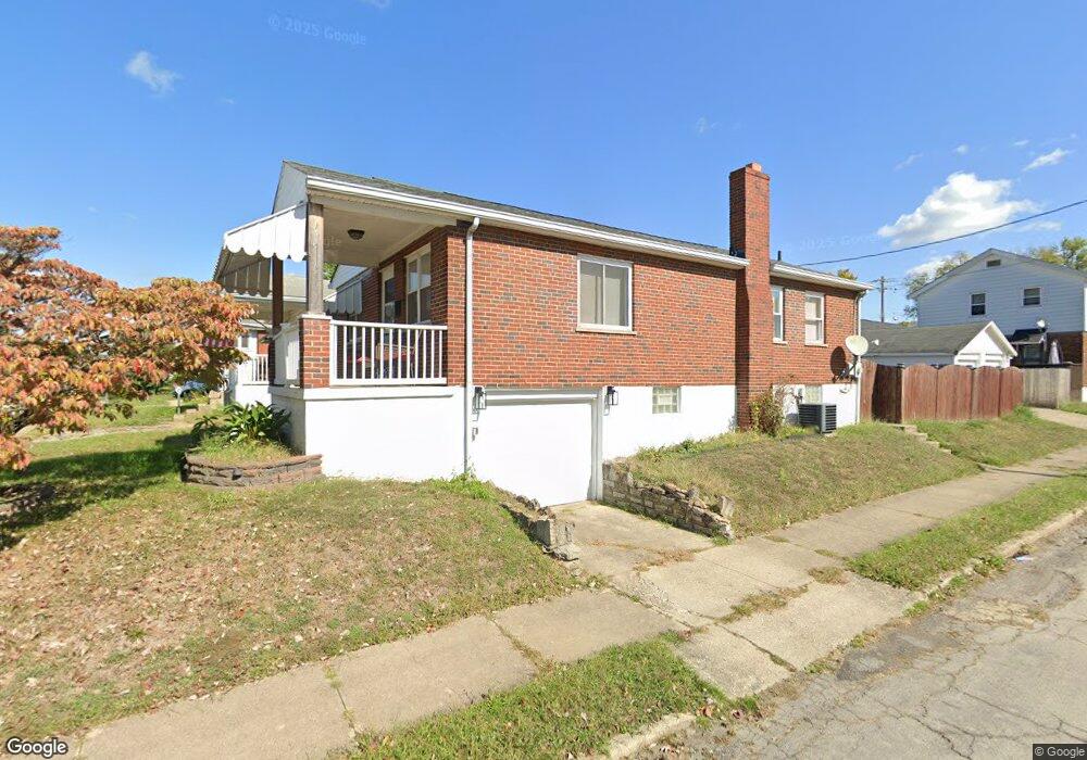
5300 Warren Ave Cincinnati, OH 45212
Estimated Value: $157,000 - $195,000
2
Beds
1
Bath
960
Sq Ft
$180/Sq Ft
Est. Value
About This Home
This home is located at 5300 Warren Ave, Cincinnati, OH 45212 and is currently estimated at $172,593, approximately $179 per square foot. 5300 Warren Ave is a home located in Hamilton County with nearby schools including Norwood High School, Summit Academy Community School - Cincinnati, and Cornerstone Christian Academy.
Ownership History
Date
Name
Owned For
Owner Type
Purchase Details
Closed on
May 15, 2006
Sold by
Gibson Onie C and Gibson Judith A
Bought by
Hiles Rhonda P and Eads Timothy L
Current Estimated Value
Home Financials for this Owner
Home Financials are based on the most recent Mortgage that was taken out on this home.
Original Mortgage
$87,700
Interest Rate
6.56%
Mortgage Type
Fannie Mae Freddie Mac
Create a Home Valuation Report for This Property
The Home Valuation Report is an in-depth analysis detailing your home's value as well as a comparison with similar homes in the area
Home Values in the Area
Average Home Value in this Area
Purchase History
| Date | Buyer | Sale Price | Title Company |
|---|---|---|---|
| Hiles Rhonda P | -- | Buckeye Land Title Company |
Source: Public Records
Mortgage History
| Date | Status | Borrower | Loan Amount |
|---|---|---|---|
| Closed | Hiles Rhonda P | $87,700 |
Source: Public Records
Tax History
| Year | Tax Paid | Tax Assessment Tax Assessment Total Assessment is a certain percentage of the fair market value that is determined by local assessors to be the total taxable value of land and additions on the property. | Land | Improvement |
|---|---|---|---|---|
| 2025 | $2,070 | $39,894 | $9,125 | $30,769 |
| 2023 | $2,065 | $39,894 | $9,125 | $30,769 |
| 2022 | $1,908 | $30,940 | $6,916 | $24,024 |
| 2021 | $1,847 | $30,940 | $6,916 | $24,024 |
| 2020 | $1,853 | $30,940 | $6,916 | $24,024 |
| 2019 | $1,761 | $27,140 | $6,066 | $21,074 |
| 2018 | $1,763 | $27,140 | $6,066 | $21,074 |
| 2017 | $1,666 | $27,140 | $6,066 | $21,074 |
| 2016 | $2,051 | $32,344 | $5,702 | $26,642 |
| 2015 | $1,825 | $32,344 | $5,702 | $26,642 |
| 2014 | $1,824 | $32,344 | $5,702 | $26,642 |
| 2013 | $1,919 | $34,409 | $6,066 | $28,343 |
Source: Public Records
Map
Nearby Homes
- 5256 Warren Ave
- 5314 Section Ave
- 5258 Hunter Ave
- 1966 Avonlea Ave
- 1958 Catalina Ave
- 5234 Hunter Ave
- 5310 Globe Ave
- 5229 Globe Ave
- 5203 Rolston Ave
- 5336 Globe Ave
- 5405 Carthage Ave
- 5360 Carthage Ave
- 1945 Lawn Ave
- 2106 Lawn Ave
- 5121 Rolston Ave
- 5119 Warren Ave
- 2119 Cathedral Ave
- 5123 Globe Ave
- 5126 Globe Ave
- 1832 Catalina Ave
- 5302 Warren Ave
- 5304 Warren Ave
- 5306 Warren Ave
- 5301 Rolston Ave
- 5303 Rolston Ave
- 5254 Warren Ave
- 5305 Rolston Ave
- 5257 Rolston Ave
- 5257 Rolston Ave Unit 2
- 5308 Warren Ave
- 5307 Rolston Ave
- 5301 Warren Ave
- 5303 Warren Ave
- 5305 Warren Ave
- 5312 Warren Ave
- 5311 Rolston Ave
- 5257 Warren Ave
- 5309 Warren Ave
- 5250 Warren Ave
- 5253 Rolston Ave
Your Personal Tour Guide
Ask me questions while you tour the home.