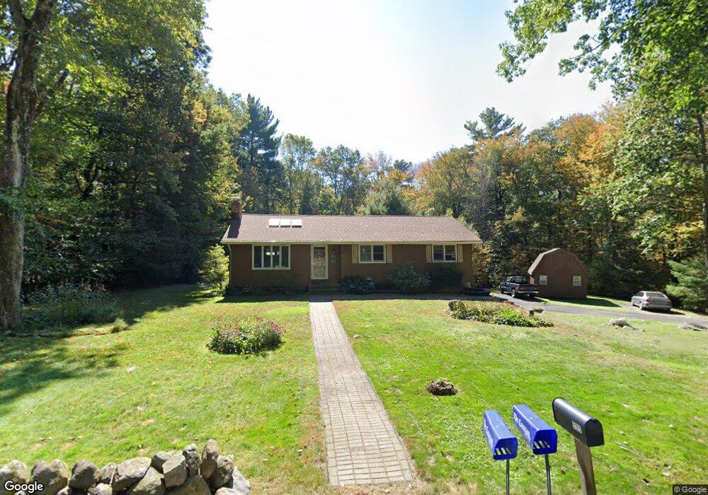
533 Buff Cap Rd Tolland, CT 06084
Estimated Value: $331,482 - $405,000
3
Beds
2
Baths
1,236
Sq Ft
$298/Sq Ft
Est. Value
About This Home
This home is located at 533 Buff Cap Rd, Tolland, CT 06084 and is currently estimated at $368,871, approximately $298 per square foot. 533 Buff Cap Rd is a home located in Tolland County with nearby schools including Tolland High School.
Ownership History
Date
Name
Owned For
Owner Type
Purchase Details
Closed on
Oct 19, 2023
Sold by
Thompson Michael J
Bought by
Thompson Jacqueline K
Current Estimated Value
Purchase Details
Closed on
Aug 9, 1985
Bought by
Thompson Michael J and Thompson Jacqueline
Create a Home Valuation Report for This Property
The Home Valuation Report is an in-depth analysis detailing your home's value as well as a comparison with similar homes in the area
Home Values in the Area
Average Home Value in this Area
Purchase History
| Date | Buyer | Sale Price | Title Company |
|---|---|---|---|
| Thompson Jacqueline K | -- | None Available | |
| Thompson Jacqueline K | -- | None Available | |
| Thompson Michael J | -- | -- |
Source: Public Records
Mortgage History
| Date | Status | Borrower | Loan Amount |
|---|---|---|---|
| Previous Owner | Thompson Michael J | $55,000 | |
| Previous Owner | Thompson Michael J | $10,000 | |
| Previous Owner | Thompson Michael J | $65,000 |
Source: Public Records
Tax History
| Year | Tax Paid | Tax Assessment Tax Assessment Total Assessment is a certain percentage of the fair market value that is determined by local assessors to be the total taxable value of land and additions on the property. | Land | Improvement |
|---|---|---|---|---|
| 2025 | $5,511 | $202,700 | $69,200 | $133,500 |
| 2024 | $5,171 | $136,900 | $65,900 | $71,000 |
| 2023 | $5,110 | $136,900 | $65,900 | $71,000 |
| 2022 | $5,008 | $136,900 | $65,900 | $71,000 |
| 2021 | $5,080 | $136,900 | $65,900 | $71,000 |
| 2020 | $4,935 | $136,900 | $65,900 | $71,000 |
| 2019 | $4,849 | $134,500 | $68,000 | $66,500 |
| 2018 | $4,708 | $134,500 | $68,000 | $66,500 |
| 2017 | $4,599 | $134,500 | $68,000 | $66,500 |
| 2016 | $4,599 | $134,500 | $68,000 | $66,500 |
| 2015 | $4,487 | $134,500 | $68,000 | $66,500 |
| 2014 | $4,599 | $148,100 | $75,500 | $72,600 |
Source: Public Records
Map
Nearby Homes
- 487 Buff Cap Rd
- 8 Neff Hill Rd
- 41 Neff Hill Rd
- 645 Buff Cap Rd
- 71 Neff Hill Rd
- 15 Usher Ridge
- 68 Usher Ridge
- 36 Usher Ridge
- 110 Neff Hill Rd
- 105 Neff Hill Rd
- 137 Neff Hill Rd
- 77 Neff Hill Rd
- 100 Neff Hill Rd
- 84 Neff Hill Rd
- 27 Amanda Way
- 50 Cook Rd
- 42 Ladd Rd
- 50 Buff Cap Rd
- 0 Tolland Turnpike
- 51 Sandy Beach Rd
- 525 Buff Cap Rd
- 539 Buff Cap Rd
- 530 Buff Cap Rd
- 522 Buff Cap Rd
- 514 Buff Cap Rd
- 515 Buff Cap Rd
- 552 Buff Cap Rd
- 505 Buff Cap Rd
- 65 Crossen Dr
- 497 Buff Cap Rd
- 57 Crossen Dr
- 49 Crossen Dr
- 62 Crossen Dr
- 41 Crossen Dr
- 54 Crossen Dr
- 31 Crossen Dr
- 486 Buff Cap Rd
- 570 Buff Cap Rd
- 21 Crossen Dr
- 479 Buff Cap Rd
Your Personal Tour Guide
Ask me questions while you tour the home.