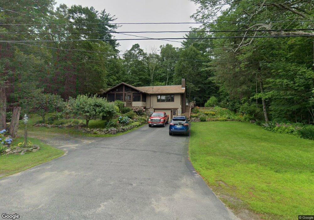
535 Us Route 3 Holderness, NH 03245
Estimated Value: $523,331 - $654,000
3
Beds
2
Baths
1,985
Sq Ft
$296/Sq Ft
Est. Value
About This Home
This home is located at 535 Us Route 3, Holderness, NH 03245 and is currently estimated at $587,583, approximately $296 per square foot. 535 Us Route 3 is a home with nearby schools including Holderness Central School and Plymouth Regional High School.
Ownership History
Date
Name
Owned For
Owner Type
Purchase Details
Closed on
Aug 23, 2002
Sold by
Patrick W Cirincione T
Bought by
Paige Sandy Roderick and Paige Sandy
Current Estimated Value
Home Financials for this Owner
Home Financials are based on the most recent Mortgage that was taken out on this home.
Original Mortgage
$150,000
Outstanding Balance
$63,563
Interest Rate
6.57%
Estimated Equity
$524,020
Create a Home Valuation Report for This Property
The Home Valuation Report is an in-depth analysis detailing your home's value as well as a comparison with similar homes in the area
Home Values in the Area
Average Home Value in this Area
Purchase History
| Date | Buyer | Sale Price | Title Company |
|---|---|---|---|
| Paige Sandy Roderick | $159,900 | -- |
Source: Public Records
Mortgage History
| Date | Status | Borrower | Loan Amount |
|---|---|---|---|
| Open | Paige Sandy Roderick | $150,000 |
Source: Public Records
Tax History Compared to Growth
Tax History
| Year | Tax Paid | Tax Assessment Tax Assessment Total Assessment is a certain percentage of the fair market value that is determined by local assessors to be the total taxable value of land and additions on the property. | Land | Improvement |
|---|---|---|---|---|
| 2024 | $3,218 | $372,000 | $71,300 | $300,700 |
| 2023 | $3,195 | $372,000 | $71,300 | $300,700 |
| 2022 | $3,425 | $305,300 | $68,400 | $236,900 |
| 2021 | $3,453 | $305,300 | $68,400 | $236,900 |
| 2020 | $3,360 | $247,400 | $61,800 | $185,600 |
| 2019 | $3,258 | $247,400 | $61,800 | $185,600 |
| 2018 | $3,184 | $247,400 | $61,800 | $185,600 |
| 2017 | $2,883 | $203,300 | $52,500 | $150,800 |
| 2016 | $2,883 | $203,300 | $52,500 | $150,800 |
| 2015 | $2,883 | $203,300 | $52,500 | $150,800 |
| 2014 | $2,890 | $201,000 | $52,500 | $148,500 |
| 2011 | $2,882 | $219,000 | $52,500 | $166,500 |
Source: Public Records
Map
Nearby Homes
- 20 Circle Dr Unit 41
- 28 Potato Island
- 35 Butternut Ln
- 384 New Hampshire 113
- 38 Range Rd
- 73 Maple Ridge Rd
- 206 High Country Way Unit (aka Unit 100)
- 265 High Country Way
- 46 Laurel Island Ln
- 7 Hollows Rd
- 47 Overlook Rd
- 37 Old Ledge Rd
- 14 Overlook Rd
- 6 Buttonwood Rd
- 11 Us Route 3
- 164 Mead Farm Rd
- 25 Elliot Rd
- 12 Peaked Hill Rd
- 283 River St
- 10 Rocky Top Ln
- 539 U S 3
- 428 Us Route 3
- 8 Marston Rd
- 541 U S 3
- 239 Shepard Hill Rd
- 253 Shepard Hill Rd
- 227 Shepard Hill Rd
- 549 Us Route 3
- 263 Shepard Hill Rd
- 242 Shepard Hill Rd
- 16 Grapevine Cove Rd
- 10 Grapevine Cove Rd
- 18 Grapevine Cove Rd
- 19 Marston Rd
- 24 Mcloud Rd
- 230 Shepard Hill Rd
- 11 Grapevine Cove Rd
- 220 Shepard Hill Rd
- 565 Us Route 3
- 8 Hammond Dr