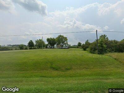
5377 State Route 47 Ansonia, OH 45303
Estimated Value: $155,000 - $252,000
4
Beds
1
Bath
2,156
Sq Ft
$103/Sq Ft
Est. Value
About This Home
This home is located at 5377 State Route 47, Ansonia, OH 45303 and is currently estimated at $222,512, approximately $103 per square foot. 5377 State Route 47 is a home located in Darke County with nearby schools including Ansonia Elementary School, Ansonia Middle School, and Ansonia High School.
Ownership History
Date
Name
Owned For
Owner Type
Purchase Details
Closed on
Jun 13, 2018
Sold by
Franklin Michael A and Franklin Hazel J
Bought by
Franklin Michael A and Franklin Hazel J
Current Estimated Value
Purchase Details
Closed on
Jul 15, 1996
Sold by
Helmer Randy
Bought by
Franklin Michael and Franklin Hazel
Home Financials for this Owner
Home Financials are based on the most recent Mortgage that was taken out on this home.
Original Mortgage
$40,800
Outstanding Balance
$5,894
Interest Rate
8.09%
Mortgage Type
New Conventional
Purchase Details
Closed on
Dec 14, 1992
Sold by
Coby Twila S
Bought by
Franklin Michael A and Franklin Hazel J
Purchase Details
Closed on
Nov 17, 1992
Bought by
Franklin Michael A and Franklin Hazel J
Create a Home Valuation Report for This Property
The Home Valuation Report is an in-depth analysis detailing your home's value as well as a comparison with similar homes in the area
Home Values in the Area
Average Home Value in this Area
Purchase History
| Date | Buyer | Sale Price | Title Company |
|---|---|---|---|
| Franklin Michael A | -- | None Available | |
| Franklin Michael | $48,000 | -- | |
| Franklin Michael A | $45,000 | -- | |
| Franklin Michael A | -- | -- |
Source: Public Records
Mortgage History
| Date | Status | Borrower | Loan Amount |
|---|---|---|---|
| Closed | Franklin Michael | $40,800 |
Source: Public Records
Tax History Compared to Growth
Tax History
| Year | Tax Paid | Tax Assessment Tax Assessment Total Assessment is a certain percentage of the fair market value that is determined by local assessors to be the total taxable value of land and additions on the property. | Land | Improvement |
|---|---|---|---|---|
| 2024 | $1,924 | $61,630 | $14,650 | $46,980 |
| 2023 | $1,927 | $61,630 | $14,650 | $46,980 |
| 2022 | $1,759 | $48,620 | $12,800 | $35,820 |
| 2021 | $1,746 | $48,620 | $12,800 | $35,820 |
| 2020 | $1,752 | $48,620 | $12,800 | $35,820 |
| 2019 | $1,665 | $48,300 | $17,160 | $31,140 |
| 2018 | $1,703 | $48,300 | $17,160 | $31,140 |
| 2017 | $1,241 | $48,300 | $17,160 | $31,140 |
| 2016 | $1,243 | $38,800 | $13,860 | $24,940 |
| 2015 | $1,243 | $38,800 | $13,860 | $24,940 |
| 2014 | $1,261 | $39,400 | $13,860 | $25,540 |
| 2013 | $1,338 | $39,120 | $13,580 | $25,540 |
Source: Public Records
Map
Nearby Homes
- 417 E Canal St
- 5400 Tamarack Trail
- 5332 Tamarack Trail
- 8892 N State Route 49
- 7833 Greenville Celina Rd
- 1031 Baker Rd
- 1025 Baker Rd
- 552 Reed Ave
- 546 Reed Ave
- 411 Reed Ave
- 547 Reed Ave
- 435 Reed Ave
- 447 Reed Ave
- 7302 State Route 121
- 7302 Ohio 121
- 49 S West St
- 0 Ohio 121
- 0000 Marker Rd
- 105 E Water St
- 129 E Wood St
- 5377 State Route 47
- 5350 State Route 47
- 5240 State Route 47
- 5170 State Route 47
- 10471 Beisner Rd
- 10563 Beisner Rd
- 5156 State Route 47
- 5636 Demming Rd
- 10555 Beisner Rd
- 10430 Beisner Rd
- 10681 Beisner Rd
- 5088 Riffle Rd
- 5343 White Coppess Rd
- 0 Demming Rd
- 5551 White Coppess Rd
- 5381 Riffle Rd
- 5580 White Coppess Rd
- 0 Beisner Rd
- 6009 Demming Rd
- 5914 Demming Rd
