
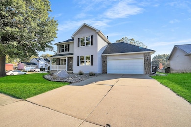
538 Fireside Dr Cedar Falls, IA 50613
Estimated payment $2,162/month
Highlights
- Deck
- Corner Lot
- Forced Air Heating and Cooling System
- Helen A. Hansen Elementary School Rated A-
- 2 Car Attached Garage
- Ceiling Fan
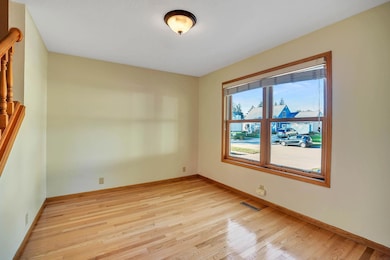
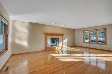
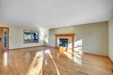
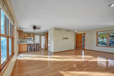
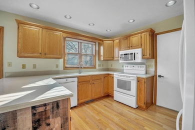
About This Home
Hard to find Cedar Falls 3-to-4-bedroom 3.25 bath home with a full finished lower-level walk out! Great location in West Cedar Falls and walking distance to schools , parks and golf course. This spacious 2story home situated on a large corner lot features an open design kitchen with plenty of countertop space and cabinets. Enjoy entertaining family and friends in the main floor family room that features a warm and inviting fireplace with access to the adjacent deck that overlooks the large back yard. Upstairs you will find 3 bedrooms including the master bedroom and bath with a walk in closet as well as an upstairs laundry. The finished lower level has a great family room with built ins, a fourth non-conforming bedroom, three quarters bath and plenty of storage.
Home Details
Home Type
- Single Family
Est. Annual Taxes
- $4,140
Year Built
- Built in 1993
Lot Details
- 9,450 Sq Ft Lot
- Lot Dimensions are 90 x 105
- Corner Lot
- Property is zoned R1-SF
Parking
- 2 Car Attached Garage
Home Design
- Concrete Foundation
- Shingle Roof
- Asphalt Roof
- Vinyl Siding
Interior Spaces
- 2,072 Sq Ft Home
- Ceiling Fan
- Panel Doors
- Living Room with Fireplace
- Finished Basement
- Sump Pump
- Laundry on upper level
Kitchen
- Dishwasher
- Disposal
Bedrooms and Bathrooms
- 4 Bedrooms
Outdoor Features
- Deck
Schools
- Hansen Elementary School
- Holmes Junior High
- Cedar Falls High School
Utilities
- Forced Air Heating and Cooling System
- Gas Water Heater
Listing and Financial Details
- Assessor Parcel Number 891411303001
Map
Home Values in the Area
Average Home Value in this Area
Tax History
| Year | Tax Paid | Tax Assessment Tax Assessment Total Assessment is a certain percentage of the fair market value that is determined by local assessors to be the total taxable value of land and additions on the property. | Land | Improvement |
|---|---|---|---|---|
| 2025 | $3,976 | $280,750 | $54,680 | $226,070 |
| 2024 | $3,976 | $257,260 | $54,680 | $202,580 |
| 2023 | $4,128 | $257,260 | $54,680 | $202,580 |
| 2022 | $4,176 | $232,440 | $54,680 | $177,760 |
| 2021 | $3,828 | $232,440 | $54,680 | $177,760 |
| 2020 | $3,746 | $214,030 | $36,450 | $177,580 |
| 2019 | $3,746 | $214,030 | $36,450 | $177,580 |
| 2018 | $3,920 | $220,820 | $36,450 | $184,370 |
| 2017 | $3,920 | $220,820 | $36,450 | $184,370 |
| 2016 | $3,748 | $220,820 | $36,450 | $184,370 |
| 2015 | $3,748 | $220,820 | $36,450 | $184,370 |
| 2014 | $3,792 | $220,820 | $36,450 | $184,370 |
Property History
| Date | Event | Price | List to Sale | Price per Sq Ft |
|---|---|---|---|---|
| 10/31/2025 10/31/25 | Pending | -- | -- | -- |
| 10/24/2025 10/24/25 | For Sale | $344,748 | -- | $166 / Sq Ft |
Purchase History
| Date | Type | Sale Price | Title Company |
|---|---|---|---|
| Quit Claim Deed | -- | None Listed On Document | |
| Joint Tenancy Deed | $214,500 | None Available |
Mortgage History
| Date | Status | Loan Amount | Loan Type |
|---|---|---|---|
| Previous Owner | $203,680 | Adjustable Rate Mortgage/ARM |
Source: Northeast Iowa Regional Board of REALTORS®
MLS Number: NBR20255251
APN: 8914-11-303-001
Disclaimer: Certain information contained herein is derived from information provided by parties other than Homes.com. All information provided is deemed reliable, but is not guaranteed to be accurate and should be independently verified.
![]() IDX information is provided exclusively for personal, non-commercial use, and may not be used for any purpose other than to identify prospective properties consumers may be interested in purchasing. Information is deemed reliable but not guaranteed.
IDX information is provided exclusively for personal, non-commercial use, and may not be used for any purpose other than to identify prospective properties consumers may be interested in purchasing. Information is deemed reliable but not guaranteed.
- 2126 Oxford Ln
- 2214 Coventry Ln
- 2907 W 3rd St
- 423 Chateau Ct
- 2126 Coventry Ln
- 1104 Warwick Dr
- 0 W 1st St
- 3702 Apollo St
- 502 Oak Park Blvd
- 223 Winding Ridge Rd
- 127 N Genevieve St
- 3413 Pheasant Dr
- 214 N Francis St
- 1212 W 7th St
- 1916 Shelden Ave
- 1618 Quail Ridge Rd
- 2706 Country Meadow Ln
- 3603 Apollo St
- 330 N Francis St
- 916 Oak Park Blvd
