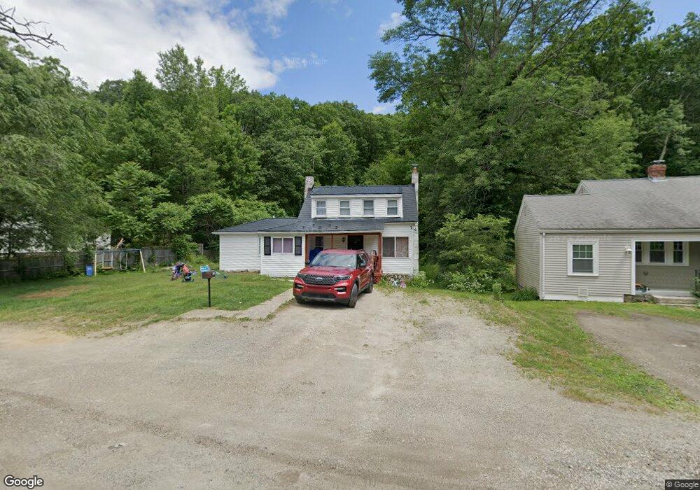
54 Dawson Rd Unit 54 Worcester, MA 01602
West Tatnuck NeighborhoodEstimated Value: $407,000 - $475,663
3
Beds
1
Bath
1,202
Sq Ft
$368/Sq Ft
Est. Value
About This Home
This home is located at 54 Dawson Rd Unit 54, Worcester, MA 01602 and is currently estimated at $441,916, approximately $367 per square foot. 54 Dawson Rd Unit 54 is a home located in Worcester County with nearby schools including Tatnuck Magnet School, Chandler Magnet, and Jacob Hiatt Magnet School.
Ownership History
Date
Name
Owned For
Owner Type
Purchase Details
Closed on
Apr 19, 2006
Sold by
Pierce Judy A
Bought by
Dawson Road Ft and Paquette
Current Estimated Value
Home Financials for this Owner
Home Financials are based on the most recent Mortgage that was taken out on this home.
Original Mortgage
$42,672
Outstanding Balance
$24,400
Interest Rate
6.37%
Mortgage Type
Purchase Money Mortgage
Estimated Equity
$417,516
Purchase Details
Closed on
Dec 28, 2001
Sold by
Pierce Judy A
Bought by
Vincequere Giovanni M
Purchase Details
Closed on
Sep 29, 1998
Sold by
Broyles John W
Bought by
Pierce Judy A
Create a Home Valuation Report for This Property
The Home Valuation Report is an in-depth analysis detailing your home's value as well as a comparison with similar homes in the area
Home Values in the Area
Average Home Value in this Area
Purchase History
| Date | Buyer | Sale Price | Title Company |
|---|---|---|---|
| Dawson Road Ft | $130,000 | -- | |
| Vincequere Giovanni M | $75,400 | -- | |
| Pierce Judy A | $78,960 | -- |
Source: Public Records
Mortgage History
| Date | Status | Borrower | Loan Amount |
|---|---|---|---|
| Open | Dawson Road Ft | $42,672 | |
| Previous Owner | Pierce Judy A | $75,400 |
Source: Public Records
Tax History Compared to Growth
Tax History
| Year | Tax Paid | Tax Assessment Tax Assessment Total Assessment is a certain percentage of the fair market value that is determined by local assessors to be the total taxable value of land and additions on the property. | Land | Improvement |
|---|---|---|---|---|
| 2025 | $4,533 | $343,700 | $120,100 | $223,600 |
| 2024 | $4,352 | $316,500 | $120,100 | $196,400 |
| 2023 | $4,011 | $279,700 | $104,500 | $175,200 |
| 2022 | $3,669 | $241,200 | $83,700 | $157,500 |
| 2021 | $3,495 | $214,700 | $67,100 | $147,600 |
| 2020 | $3,354 | $197,300 | $67,000 | $130,300 |
| 2019 | $3,227 | $179,300 | $60,700 | $118,600 |
| 2018 | $3,236 | $171,100 | $60,700 | $110,400 |
| 2017 | $2,870 | $149,300 | $60,700 | $88,600 |
| 2016 | $2,852 | $138,400 | $46,200 | $92,200 |
| 2015 | $2,778 | $138,400 | $46,200 | $92,200 |
| 2014 | $2,704 | $138,400 | $46,200 | $92,200 |
Source: Public Records
Map
Nearby Homes
- 155 Tory Fort Ln
- 12 Pinebrook Ln
- 148A Tory Fort Ln
- 25 Salisbury Hill Blvd Unit 64
- 25 Salisbury Hill Blvd Unit 69
- 25 Salisbury Hill Blvd Unit 67
- 25 Salisbury Hill Blvd Unit 51
- 25 Salisbury Hill Blvd Unit 65
- 10 Salisbury Hill Blvd Unit 75
- 3 Carter Way
- 5 Forest Hill Dr
- 9 Newburn Rd
- 4 Barrows Rd
- 58 Wedgewood Rd
- 20 Wedgewood Rd
- 15 Wildrose Ave
- 288 Fisher Rd
- 770 Salisbury St Unit 201
- 617 Salisbury St
- 2 Baiting Brook Ln Unit 71