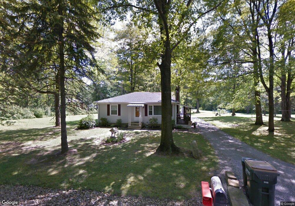
541 King Ave Youngstown, OH 44514
Estimated Value: $160,000 - $172,000
2
Beds
1
Bath
884
Sq Ft
$188/Sq Ft
Est. Value
About This Home
This home is located at 541 King Ave, Youngstown, OH 44514 and is currently estimated at $166,589, approximately $188 per square foot. 541 King Ave is a home located in Mahoning County with nearby schools including Stadium Drive Elementary School, Boardman Glenwood Junior High School, and Boardman High School.
Ownership History
Date
Name
Owned For
Owner Type
Purchase Details
Closed on
Feb 4, 2004
Sold by
Basinger J Paul and Basinger Sandra K
Bought by
Telford Mark W and Telford Kimberly M
Current Estimated Value
Home Financials for this Owner
Home Financials are based on the most recent Mortgage that was taken out on this home.
Original Mortgage
$85,337
Outstanding Balance
$38,139
Interest Rate
5.71%
Mortgage Type
VA
Estimated Equity
$128,450
Purchase Details
Closed on
Nov 8, 1971
Bought by
Edmonds Isabell K
Create a Home Valuation Report for This Property
The Home Valuation Report is an in-depth analysis detailing your home's value as well as a comparison with similar homes in the area
Purchase History
| Date | Buyer | Sale Price | Title Company |
|---|---|---|---|
| Telford Mark W | $83,500 | -- | |
| Edmonds Isabell K | -- | -- |
Source: Public Records
Mortgage History
| Date | Status | Borrower | Loan Amount |
|---|---|---|---|
| Open | Telford Mark W | $85,337 |
Source: Public Records
Tax History
| Year | Tax Paid | Tax Assessment Tax Assessment Total Assessment is a certain percentage of the fair market value that is determined by local assessors to be the total taxable value of land and additions on the property. | Land | Improvement |
|---|---|---|---|---|
| 2025 | $1,751 | $34,820 | $2,520 | $32,300 |
| 2024 | $1,754 | $34,820 | $2,520 | $32,300 |
| 2023 | $1,730 | $34,820 | $2,520 | $32,300 |
| 2022 | $1,655 | $26,070 | $2,500 | $23,570 |
| 2021 | $1,658 | $26,070 | $2,500 | $23,570 |
| 2020 | $1,667 | $26,070 | $2,500 | $23,570 |
| 2019 | $1,605 | $23,700 | $2,270 | $21,430 |
| 2018 | $1,431 | $23,700 | $2,270 | $21,430 |
| 2017 | $1,429 | $23,700 | $2,270 | $21,430 |
| 2016 | $1,465 | $23,970 | $1,860 | $22,110 |
| 2015 | $1,434 | $23,970 | $1,860 | $22,110 |
| 2014 | $1,439 | $23,970 | $1,860 | $22,110 |
| 2013 | $1,426 | $23,970 | $1,860 | $22,110 |
Source: Public Records
Map
Nearby Homes
- 601 E Western Reserve Rd Unit 1401
- 601 E Western Reserve Rd Unit 1903
- 601 E Western Reserve Rd Unit 701
- 0 W Harvard Blvd
- 0 Harvard Rd Unit 5038029
- 363 Maple Dr
- 695 E Western Reserve Rd Unit 1903
- 331 Warren Ave
- 9140 Woodworth Rd
- 717 Calla Rd E
- 62 E Western Reserve Rd Unit 3
- 9687 South Ave
- 0 W Western Reserve Rd Unit 5188999
- 1008 E Calla Rd
- 1275 E Western Reserve Rd
- 1070 Calla Rd E
- 828 Woodfield Ct Unit A
- 9264 Sharrott Rd Unit 1001
- 9264 Sharrott Rd Unit 801
- 9264 Sharrott Rd Unit 104
Your Personal Tour Guide
Ask me questions while you tour the home.