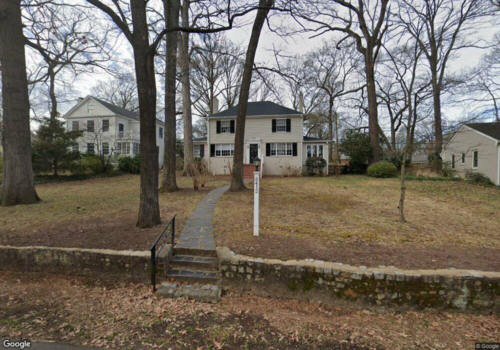
5412 New Kent Rd Richmond, VA 23225
Westover Hills NeighborhoodEstimated Value: $665,000 - $720,000
3
Beds
2
Baths
1,965
Sq Ft
$353/Sq Ft
Est. Value
About This Home
This home is located at 5412 New Kent Rd, Richmond, VA 23225 and is currently estimated at $693,628, approximately $352 per square foot. 5412 New Kent Rd is a home located in Richmond City with nearby schools including Westover Hills Elementary School, Huguenot High School, and Open High School.
Ownership History
Date
Name
Owned For
Owner Type
Purchase Details
Closed on
Jan 13, 1998
Sold by
Torrice Joseph H and Torrice Mary D
Bought by
Sites Joseph L and Caroline H Kettlewell/H W
Current Estimated Value
Home Financials for this Owner
Home Financials are based on the most recent Mortgage that was taken out on this home.
Original Mortgage
$116,250
Outstanding Balance
$20,086
Interest Rate
7.09%
Mortgage Type
New Conventional
Estimated Equity
$673,542
Create a Home Valuation Report for This Property
The Home Valuation Report is an in-depth analysis detailing your home's value as well as a comparison with similar homes in the area
Home Values in the Area
Average Home Value in this Area
Purchase History
| Date | Buyer | Sale Price | Title Company |
|---|---|---|---|
| Sites Joseph L | $155,000 | -- | |
| Sites Joseph L | $155,000 | -- |
Source: Public Records
Mortgage History
| Date | Status | Borrower | Loan Amount |
|---|---|---|---|
| Open | Sites Joseph L | $116,250 | |
| Closed | Sites Joseph L | $116,250 |
Source: Public Records
Tax History Compared to Growth
Tax History
| Year | Tax Paid | Tax Assessment Tax Assessment Total Assessment is a certain percentage of the fair market value that is determined by local assessors to be the total taxable value of land and additions on the property. | Land | Improvement |
|---|---|---|---|---|
| 2025 | $7,212 | $601,000 | $256,000 | $345,000 |
| 2024 | $6,444 | $537,000 | $197,000 | $340,000 |
| 2023 | $5,964 | $497,000 | $157,000 | $340,000 |
| 2022 | $5,316 | $443,000 | $157,000 | $286,000 |
| 2021 | $4,308 | $379,000 | $110,000 | $269,000 |
| 2020 | $4,308 | $359,000 | $110,000 | $249,000 |
| 2019 | $4,104 | $342,000 | $110,000 | $232,000 |
| 2018 | $3,900 | $325,000 | $70,000 | $255,000 |
| 2017 | $3,720 | $310,000 | $70,000 | $240,000 |
| 2016 | $3,612 | $301,000 | $70,000 | $231,000 |
| 2015 | $3,600 | $300,000 | $70,000 | $230,000 |
| 2014 | $3,600 | $300,000 | $70,000 | $230,000 |
Source: Public Records
Map
Nearby Homes
- 1722 Leicester Rd
- 5636 Forest Hill Ave
- 5204 Forest Hill Ave
- 2324 N Riverside Dr
- 5205 Forest Hill Ave
- 5504 Riverside Heights Way
- 5021 Caledonia Rd
- 5804 Riverside Dr
- 5600 Riverside Heights Way
- 2320 Pineway Dr
- 5612 Southern Pine Dr
- 12 Tow Path Ln S
- 1004 Hill Top Dr
- 14 Old Canal Rd
- 2006 Southcliff Rd
- 4621 Devonshire Rd
- 1937 Lansing Ave
- 912 Forest View Dr
- 4605 Forest Hill Ave
- 911 Hill Top Dr
- 5410 New Kent Rd
- 5414 New Kent Rd
- 5408 New Kent Rd
- 5421 Dorchester Rd
- 5419 Dorchester Rd
- 5500 Riverside Dr
- 5415 New Kent Rd
- 5423 Dorchester Rd
- 5406 New Kent Rd
- 5416 New Kent Rd
- 5415 Dorchester Rd
- 5505 Riverside Dr
- 5502 Riverside Dr
- 5404 New Kent Rd
- 5501 Riverside Dr
- 5411 Dorchester Rd
- 5501 Dorchester Rd
- 5424 Dorchester Rd
- 5426 Dorchester Rd
- 5422 Dorchester Rd