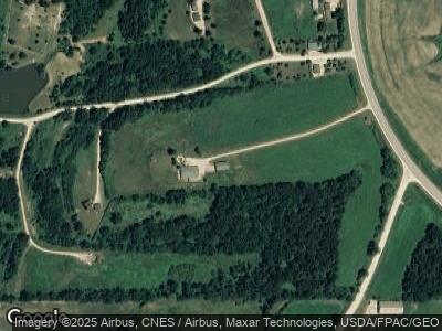
542 State Highway 76 Harpers Ferry, IA 52146
Estimated Value: $514,000 - $645,000
9
Beds
3
Baths
3,960
Sq Ft
$146/Sq Ft
Est. Value
About This Home
This home is located at 542 State Highway 76, Harpers Ferry, IA 52146 and is currently estimated at $578,333, approximately $146 per square foot. 542 State Highway 76 is a home located in Allamakee County with nearby schools including West Campus Elementary School, East Campus Elementary School, and Waukon Middle School.
Ownership History
Date
Name
Owned For
Owner Type
Purchase Details
Closed on
Dec 15, 2022
Sold by
Garrity Maura A
Bought by
Iowa Cabin Rentals Llc
Current Estimated Value
Home Financials for this Owner
Home Financials are based on the most recent Mortgage that was taken out on this home.
Original Mortgage
$600,000
Interest Rate
7.08%
Mortgage Type
Credit Line Revolving
Purchase Details
Closed on
Nov 11, 2011
Sold by
Wehrenberg John R and Garrity Maura A
Bought by
Garrity Maura A
Create a Home Valuation Report for This Property
The Home Valuation Report is an in-depth analysis detailing your home's value as well as a comparison with similar homes in the area
Home Values in the Area
Average Home Value in this Area
Purchase History
| Date | Buyer | Sale Price | Title Company |
|---|---|---|---|
| Iowa Cabin Rentals Llc | $585,000 | -- |
Source: Public Records
Mortgage History
| Date | Status | Borrower | Loan Amount |
|---|---|---|---|
| Closed | Iowa Cabin Rentals Llc | $600,000 | |
| Previous Owner | Garrity Maura A | $25,000 | |
| Previous Owner | Spraggins Hugh A | $35,000 |
Source: Public Records
Tax History Compared to Growth
Tax History
| Year | Tax Paid | Tax Assessment Tax Assessment Total Assessment is a certain percentage of the fair market value that is determined by local assessors to be the total taxable value of land and additions on the property. | Land | Improvement |
|---|---|---|---|---|
| 2024 | $2,012 | $167,000 | $19,200 | $147,800 |
| 2023 | $2,012 | $167,000 | $19,200 | $147,800 |
| 2022 | $1,624 | $129,400 | $16,000 | $113,400 |
| 2021 | $1,660 | $131,100 | $17,700 | $113,400 |
| 2020 | $1,660 | $128,000 | $17,800 | $110,200 |
| 2019 | $1,614 | $134,600 | $0 | $0 |
| 2018 | $1,558 | $134,600 | $0 | $0 |
| 2017 | $1,558 | $129,000 | $0 | $0 |
| 2016 | $1,406 | $129,000 | $0 | $0 |
| 2015 | $1,406 | $133,300 | $0 | $0 |
| 2014 | $1,438 | $133,300 | $0 | $0 |
Source: Public Records
Map
Nearby Homes
- 1726 Wynn Wood Ln
- 2194 Mound View Ln
- xxx Mound View Ln
- 0 Dry Hollow Rd
- 144 Cross St
- 27073 Pleasant Ridge Rd
- 32311 Ambro Rd
- 831 Stilwell Ln
- 2335 Andy Mountain Ln
- 0000 Timber Ridge Ln
- 63574 Lohmann Ln
- 2316 Edwards Ln
- 603 Sandy Point Rd Unit 111
- 603 Sandy Point Rd Unit 113
- 518 Sandy Point Rd
- 314 W Chestnut St
- 2340 Longview Ln
- 685 Bear Hollow Rd
- 33150 Donna Dr
- 33150 Donna Dr Unit 14
- 542 State Highway 76
- 542 Hwy 76
- 516 Doe Ln Unit Deer Tracks Lot 17
- 1804 Trophy Run Ln
- 1803 Trophy Run Ln
- 1809 Buck Ln
- 548 State Highway 76
- 548 State Highway 76
- 1826 Buck Ln
- 1823 Buck Ln
- 1813 Buck Ln
- 1824 Buck Ln
- 1819 Buck Ln
- 485 Ion Rd
- 478 Ion Rd
- 1861 Trophy Run Ln
- 1815 Buck Ln
- 1870 Trophy Run Ln
- 1831 Marvins Park Ln
- 1864 Trophy Run Ln
